
Paypay:Balkan topo en.jpg

Kadako hin nga pahiuna nga pagawas: 657 × 600 nga mga pixel. Iba nga mga resolusyon: 263 × 240 nga mga pixel | 526 × 480 nga mga pixel | 840 × 767 nga mga pixel.
Orihinal nga paypay (840 × 767 nga pixel, kadako han fayl: 638 nga KB, MIME nga tipo: image/jpeg)
Dalikyat nga pulong
| Tigtulidong |
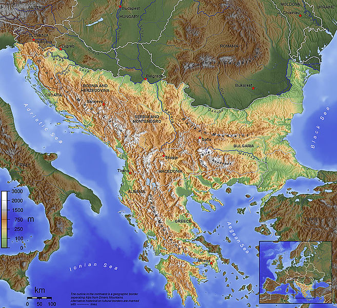
English: The topography of the Balkan Peninsula, as defined by the Danube-Sava-Kupa line. |
||||||||||
| Petsa | 2006, before Serbia and Montenegro was split into two separate states. | ||||||||||
| Ginkuhaan | Kalugaringon nga buhat | ||||||||||
| Awtor | Captain Blood~commonswiki | ||||||||||
| Pagtugot (Gin-uutro paggamit inin nga file) |
|
||||||||||
| Other versions |
|

Kaagi han paypay
Pidlita an adlaw/oras para makit-an an fayl nga naggawas hito nga oras.
| Pitsa/Oras | Thumbnail | Mga dimensyon | Gumaramit | Komento | |
|---|---|---|---|---|---|
| waray pa kasasapawi | 09:15, 14 Nobyembre 2015 | | 840 × 767 (638 nga KB) | SilentResident | Corrected mistake in which the Aegean and Ionian islands were marked as part of the Balkan topography. |
| 21:53, 1 Pebrero 2012 |  | 1,384 × 1,264 (726 nga KB) | Ras67 | losslessly cropped with Jpegcrop | |
| 21:52, 1 Pebrero 2012 |  | 1,384 × 1,264 (726 nga KB) | Ras67 | losslessly cropped with Jpegcrop | |
| 17:34, 14 Abril 2006 |  | 1,400 × 1,278 (748 nga KB) | Captain Blood~commonswiki | labels | |
| 17:22, 2 Abril 2006 |  | 1,400 × 1,278 (748 nga KB) | Captain Blood~commonswiki | Una border | |
| 19:38, 1 Abril 2006 |  | 1,400 × 1,278 (741 nga KB) | Captain Blood~commonswiki | {{Bild-GFDL-GMT}} |
Mga Sumpay
An mga nasunod nga mga pakli nasumpay hini nga paypay:
Global file usage
An masunod nga iba nga mga wiki in nagamit hini nga file:
- Paggamit ha af.wikipedia.org
- Paggamit ha ang.wikipedia.org
- Paggamit ha an.wikipedia.org
- Paggamit ha ar.wikipedia.org
- Paggamit ha arz.wikipedia.org
- Paggamit ha ast.wikipedia.org
- Paggamit ha be-tarask.wikipedia.org
- Paggamit ha bg.wikipedia.org
- Paggamit ha bn.wikipedia.org
- Paggamit ha bs.wikipedia.org
- Paggamit ha ca.wikipedia.org
- Paggamit ha ckb.wikipedia.org
Kitaa durudamo nga global usage hinin nga file.