
Paypay:Galapagos Islands topographic map-de.svg

Size of this PNG preview of this SVG file: 600 × 600 nga mga pixel. Iba nga mga resolusyon: 240 × 240 nga mga pixel | 480 × 480 nga mga pixel | 768 × 768 nga mga pixel | 1,024 × 1,024 nga mga pixel | 2,048 × 2,048 nga mga pixel | 2,160 × 2,160 nga mga pixel.
Orihinal nga paypay (SVG nga fayl, ginbabanabanahan nga 2,160 × 2,160 nga mga pixel, kadako han fayl: 2.62 nga MB)
Dalikyat nga pulong
| Object location | | View this and other nearby images on: OpenStreetMap |
|---|
| Tigtulidong |
|
| Petsa | |
| Ginkuhaan |
Own work
|
| Awtor | Eric Gaba (Sting - fr:Sting), translated by NordNordWest |
| Pagtugot (Gin-uutro paggamit inin nga file) |
GFDL / Attribution and Share-Alike required |
| Other versions |
[]
|

.png)


|
This SVG file contains embedded text that can be translated into your language, using any capable SVG editor, text editor or the SVG Translate tool. For more information see: About translating SVG files. |
Palilisensya:
I, the copyright holder of this work, hereby publish it under the following licenses:

|
An permiso in ginhatag ha pagkopya, pagpakalat ngan/o pagliwat hinin nga dokumento ha ilarom han mga termino han GNU Free Documentation License, Version 1.2 o mas uruurhi nga version nga ginmantala han Free Software Foundation; nga may-ada waray Invariant Sections, waray Front-Cover Texts, ngan waray Back-Cover Texts. May-ada kopya hin lisensya nga ginlalakip ha seksyon nga may-ada pamagat nga GNU Free Documentation License. |
This file is licensed under the Creative Commons Attribution-Share Alike 4.0 International, 3.0 Unported, 2.5 Generic, 2.0 Generic and 1.0 Generic license.
- Talwas ka:
- para han pagpasaro – para han pagkopya, pagpakalat ngan pagpadangat han buhat
- para han pagremix – pag-adapt han buhat
- Ha ilarom an masunod nga mga kondisyon:
- attribution – Kinahanglanon mo tagan hin kaangayan nga credit, paghatag hin sumpay ngadto ha lisensya, ngan igbutang an imo ginbag-ohan nga binuhat. Puydi mo ini buhaton ha bisan ano nga resonable nga pamaagi, pero diri nimo pagawson nga an naghatag hin lisensya nag-eendorso ha imo o ha imo paggamit.
- share alike – Kun imo ginsagol-hin-otro, gin-iba, o gin-hingayad han buhat, ikaw in angay gud là magpakalat han imo gin-amot ha ilarom la han [http:creativecommons.org/share-your-work/licensing-considerations/compatible-licenses pareho o naangay nga lisensya] sugad han orihinal.
Puydi ka pumili hin lisenysa nga karuyag mo.
Kaagi han paypay
Pidlita an adlaw/oras para makit-an an fayl nga naggawas hito nga oras.
| Pitsa/Oras | Thumbnail | Mga dimensyon | Gumaramit | Komento | |
|---|---|---|---|---|---|
| waray pa kasasapawi | 17:36, 11 Hunyo 2016 | | 2,160 × 2,160 (2.62 nga MB) | NordNordWest | Bahia Tortuga corrected |
| 19:33, 3 Nobyembre 2008 |  | 2,160 × 2,160 (2.62 nga MB) | NordNordWest | corrected | |
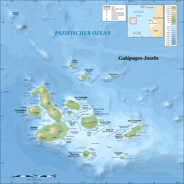
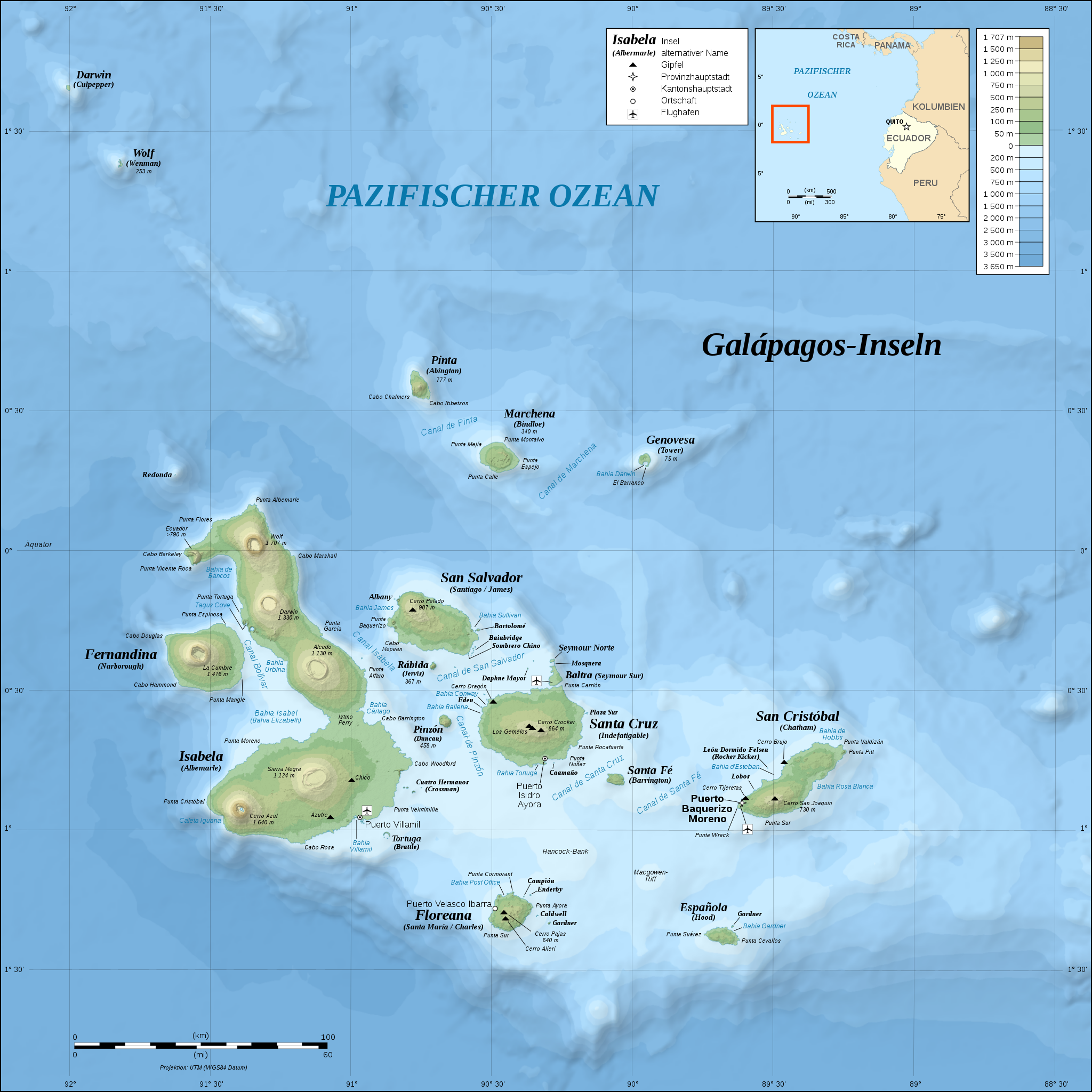
| 17:07, 26 Oktubre 2008 |  | 2,160 × 2,160 (2.62 nga MB) | NordNordWest | {{Location|00|30|00|S|90|30|00|W|scale:1000000}} <br/>{{Information |Description= {{de|Topografische and bathymetrische Karte der Galápagos-Inseln, Ecuador.}} {{en|Topographic and bathymetric map of the [[:en:Gal |
Mga Sumpay
An mga nasunod nga mga pakli nasumpay hini nga paypay:
Global file usage
An masunod nga iba nga mga wiki in nagamit hini nga file:
- Paggamit ha af.wikipedia.org
- Paggamit ha cs.wikipedia.org
- Paggamit ha de.wikipedia.org
- Paggamit ha de.wikivoyage.org
- Paggamit ha en.wikisource.org
- Paggamit ha eo.wikipedia.org
- Paggamit ha fo.wikipedia.org
- Paggamit ha frr.wikipedia.org
- Paggamit ha gl.wikipedia.org
- Paggamit ha hu.wikipedia.org
- Paggamit ha it.wikipedia.org
- Paggamit ha it.wikivoyage.org
- Paggamit ha ko.wikipedia.org
- Paggamit ha nn.wikipedia.org
- Paggamit ha ro.wikipedia.org
- Paggamit ha sl.wikipedia.org
- Paggamit ha stq.wikipedia.org