
Paypay:IrishSeaReliefMap.jpg
Kadako hin nga pahiuna nga pagawas: 415 × 600 nga mga pixel. Iba nga mga resolusyon: 166 × 240 nga mga pixel | 332 × 480 nga mga pixel | 531 × 768 nga mga pixel | 1,043 × 1,507 nga mga pixel.
Orihinal nga paypay (1,043 × 1,507 nga pixel, kadako han fayl: 2.15 nga MB, MIME nga tipo: image/jpeg)
Dalikyat nga pulong
| Tigtulidong |
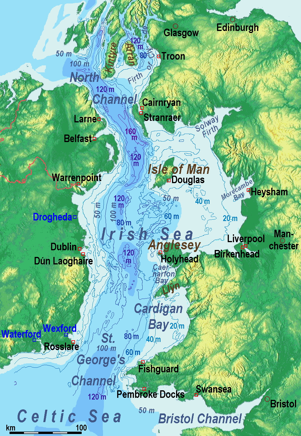
A map of the en:Irish Sea. Major ports shown with red marks. freight-only ports in blue. |
| Petsa | old map 2005-08-03; new map 2014-05-11 |
| Ginkuhaan | old map: http://www.vindaloo.uklinux.net/jjg/code/tmutils.html-> new map: Maps for Free and Kalugaringon nga buhat |
| Awtor | old one Users SFC9394, Seabhcan on en.wikipedia, new one Ulamm (talk) 01:37, 11 May 2014 (UTC) |
| Pagtugot (Gin-uutro paggamit inin nga file) |
old map: from http://www.vindaloo.uklinux.net/jjg/code/tmutils.html. Released to public domain by creator. |
| Other versions |
History of the od map
Old map riginally from en.wikipedia; description page is (was) here
- 14:22, 20 March 2006 SFC9394 461×561 (85,860 bytes) (Corrected locations for Cairnryan & Stranraer)
- 10:56, 25 November 2005 Seabhcan 461×561 (73,292 bytes) (Removed the ports of Heysham and Fleetwood, to which en:User:Robdurbar took offence. )
- 16:23, 3 August 2005 Seabhcan 461×561 (95,162 bytes) (Added channel names)
- 15:50, 3 August 2005 Seabhcan 461×561 (93,219 bytes) (A map of the en:Irish Sea Major ports shown in red. freight only ports in blue. from [1]. Released to public domain by creator.)
Sources of information for the new map
- internal report Nr. 174 of the National Oceanography Centre (Liverpool)
- http://www.dcenr.gov.ie (Department of Communications, Energy and Natural Resources) -> IOSEA4Annex–Master–r02–Fiinal.pdf (Fourth Strategic Environmental Assessment for Oil and Gas ACtivity in Irelands Offshore Waters) -> figures 2.1 & 2.2a
Palilisensya:
I, the copyright holder of this work, hereby publish it under the following license:
Ini nga file in nakalisensya ha ilarom han Creative Commons Attribution-Share Alike 3.0 Unported license.
- Talwas ka:
- para han pagpasaro – para han pagkopya, pagpakalat ngan pagpadangat han buhat
- para han pagremix – pag-adapt han buhat
- Ha ilarom an masunod nga mga kondisyon:
- attribution – Kinahanglanon mo tagan hin kaangayan nga credit, paghatag hin sumpay ngadto ha lisensya, ngan igbutang an imo ginbag-ohan nga binuhat. Puydi mo ini buhaton ha bisan ano nga resonable nga pamaagi, pero diri nimo pagawson nga an naghatag hin lisensya nag-eendorso ha imo o ha imo paggamit.
- share alike – Kun imo ginsagol-hin-otro, gin-iba, o gin-hingayad han buhat, ikaw in angay gud là magpakalat han imo gin-amot ha ilarom la han [http:creativecommons.org/share-your-work/licensing-considerations/compatible-licenses pareho o naangay nga lisensya] sugad han orihinal.
(Uploaded using CommonsHelper or PushForCommons)
Kaagi han paypay
Pidlita an adlaw/oras para makit-an an fayl nga naggawas hito nga oras.
| Pitsa/Oras | Thumbnail | Mga dimensyon | Gumaramit | Komento | |
|---|---|---|---|---|---|
| waray pa kasasapawi | 11:42, 13 Mayo 2014 | | 1,043 × 1,507 (2.15 nga MB) | Ulamm | optimized colour scale |
| 14:17, 12 Mayo 2014 |  | 1,043 × 1,507 (1.87 nga MB) | Ulamm | more names, smaller letters | |
| 12:25, 11 Mayo 2014 |  | 1,043 × 1,449 (1.73 nga MB) | Ulamm | depths and names of bays and inlets | |
| 10:56, 11 Mayo 2014 |  | 1,043 × 1,449 (1.71 nga MB) | Ulamm | land colours lightened | |
| 02:22, 11 Mayo 2014 |  | 1,043 × 1,449 (1.7 nga MB) | Ulamm | more ports | |
| 01:50, 11 Mayo 2014 |  | 1,043 × 1,449 (1.69 nga MB) | Ulamm | completion outside the Irish Sea | |
| 01:39, 11 Mayo 2014 |  | 1,043 × 1,449 (1.68 nga MB) | Ulamm | completely new map | |
| 09:01, 1 Nobyembre 2006 |  | 461 × 561 (84 nga KB) | Korrigan | {{Information| |Description= A map of the en:Irish Sea Major ports shown in red. freight only ports in blue. |Source= |Date= |Author=Users SFC9394, Seabhcan on [http://en.wikipedia.org en.wikipedia] |Permiss |
Mga Sumpay
An mga nasunod nga mga pakli nasumpay hini nga paypay:
Global file usage
An masunod nga iba nga mga wiki in nagamit hini nga file:
- Paggamit ha af.wikipedia.org
- Paggamit ha an.wikipedia.org
- Paggamit ha ast.wikipedia.org
- Paggamit ha ba.wikipedia.org
- Paggamit ha be.wikipedia.org
- Paggamit ha bg.wikipedia.org
- Paggamit ha bn.wikipedia.org
- Paggamit ha br.wikipedia.org
- Paggamit ha ca.wikipedia.org
- Paggamit ha cs.wikipedia.org
- Paggamit ha cv.wikipedia.org
- Paggamit ha cy.wikipedia.org
- Paggamit ha da.wikipedia.org
- Paggamit ha el.wikipedia.org
- Paggamit ha eo.wikipedia.org
- Paggamit ha es.wikipedia.org
- Paggamit ha eu.wikipedia.org
- Paggamit ha fa.wikipedia.org
- Paggamit ha fy.wikipedia.org
- Paggamit ha gl.wikipedia.org
- Paggamit ha gv.wikipedia.org
- Paggamit ha he.wikipedia.org
- Paggamit ha hu.wikipedia.org
- Paggamit ha hu.wiktionary.org
- Paggamit ha id.wikipedia.org
- Paggamit ha is.wikipedia.org
- Paggamit ha ka.wikipedia.org
- Paggamit ha kk.wikipedia.org
- Paggamit ha ko.wikipedia.org
- Paggamit ha ku.wikipedia.org
- Paggamit ha lmo.wikipedia.org
Kitaa durudamo nga global usage hinin nga file.