
Paypay:Karte NOE Viertel Bezirke.svg

Size of this PNG preview of this SVG file: 666 × 599 nga mga pixel. Iba nga mga resolusyon: 267 × 240 nga mga pixel | 533 × 480 nga mga pixel | 853 × 768 nga mga pixel | 1,138 × 1,024 nga mga pixel | 2,276 × 2,048 nga mga pixel | 1,000 × 900 nga mga pixel.
Orihinal nga paypay (SVG nga fayl, ginbabanabanahan nga 1,000 × 900 nga mga pixel, kadako han fayl: 82 nga KB)
Dalikyat nga pulong
| Tigtulidong |
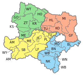
English: Map of Lower Austria showing districts with different colors for Waldviertel, Weinviertel, Mostviertel and Industrieviertel.
Deutsch: Karte von Niederösterreich, eingezeichnet die Bezirke und die vier Viertel: Waldviertel, Weinviertel, Mostviertel und Industrieviertel.
Waldviertel
Weinviertel
Mostviertel
Industrieviertel |
| Petsa | |
| Ginkuhaan | Own work, based on [1] |
| Awtor | AleXXw |
| Other versions |
|


![[1]](http://www.noe.gv.at/bilder/d17/BD5noe31-Viertelsgrenzen.png?7150)
Palilisensya:
| I, the copyright holder of this work, release this work into the public domain. This applies worldwide. In some countries this may not be legally possible; if so: I grant anyone the right to use this work for any purpose, without any conditions, unless such conditions are required by law. |
Kaagi han paypay
Pidlita an adlaw/oras para makit-an an fayl nga naggawas hito nga oras.
| Pitsa/Oras | Thumbnail | Mga dimensyon | Gumaramit | Komento | |
|---|---|---|---|---|---|
| waray pa kasasapawi | 15:26, 4 Pebrero 2017 | | 1,000 × 900 (82 nga KB) | Ailura | Versuch ohne WU |
| 14:23, 4 Pebrero 2017 |  | 1,000 × 900 (67 nga KB) | FDMS4 | Reverted to version as of 22:24, 16 February 2015 (UTC): not a vector file; parts of Viertel border missing | |
| 14:42, 3 Enero 2017 |  | 420 × 378 (131 nga KB) | Kontrollstellekundl | 2017 -WU | |
| 22:24, 16 Pebrero 2015 |  | 1,000 × 900 (67 nga KB) | Ailura | - SW | |
| 22:22, 16 Pebrero 2015 |  | 1,000 × 900 (67 nga KB) | Ailura | SW ist kein bezirk | |
| 22:10, 14 Pebrero 2015 |  | 1,000 × 900 (67 nga KB) | Ailura | Layers | |
| 18:30, 7 Mayo 2009 |  | 1,000 × 900 (93 nga KB) | AleXXw | {{Information |Description= {{en|Map of Lower Austria showing districts with different colors for Waldviertel, Weinviertel, Mostviertel and Industrieviertel.}} {{de|Karte von Niederösterreich, eingezeichnet die Bezirke und die vie |
Mga Sumpay
An mga nasunod nga mga pakli nasumpay hini nga paypay:
- Amstetten (distrito)
- Baden (distrito han Austria)
- Bruck an der Leitha (distrito)
- Gmünd (distrito)
- Gänserndorf (distrito)
- Hollabrunn (distrito)
- Horn (distrito)
- Korneuburg (distrito)
- Krems-Land (distrito)
- Krems an der Donau
- Lilienfeld (distrito)
- Melk (distrito)
- Mistelbach (distrito)
- Mödling (distrito)
- Neunkirchen (distrito han Austria)
- Sankt Pölten
- Sankt Pölten-Land (distrito)
- Scheibbs (distrito)
- Tulln (distrito)
- Uruubos nga Austria
- Waidhofen an der Thaya (distrito)
- Waidhofen an der Ybbs
- Wien-Umgebung (distrito)
- Wiener Neustadt
- Wiener Neustadt-Land (distrito)
- Zwettl (distrito)
- Batakan:Uruubos nga Austria
Global file usage
An masunod nga iba nga mga wiki in nagamit hini nga file:
- Paggamit ha cs.wikipedia.org
- Paggamit ha de.wikipedia.org
- Paggamit ha en.wikipedia.org
- Sankt Pölten
- Krems an der Donau
- Wiener Neustadt
- Melk District
- Template:Lower Austria
- Waidhofen an der Ybbs
- Korneuburg District
- Amstetten District
- Baden District, Austria
- Bruck an der Leitha District
- Gänserndorf District
- Gmünd District
- Hollabrunn District
- Horn District
- Krems-Land District
- Lilienfeld District
- Mistelbach District
- Mödling District
- Sankt Pölten-Land District
- Scheibbs District
- Tulln District
- Waidhofen an der Thaya District
- Wiener Neustadt-Land District
- Zwettl District
- Neunkirchen District, Austria
- Wikipedia:WikiProject Navigation templates/Country subdivisions/Austria
- Paggamit ha eo.wikipedia.org
- Paggamit ha es.wikipedia.org
- Paggamit ha fr.wikipedia.org
- Paggamit ha it.wikipedia.org
- Paggamit ha mk.wikipedia.org
- Paggamit ha mn.wikipedia.org
- Paggamit ha pt.wikipedia.org
Kitaa durudamo nga global usage hinin nga file.