
Paypay:Papilio glaucus range map.JPG

Kadako hin nga pahiuna nga pagawas: 519 × 599 nga mga pixel. Iba nga mga resolusyon: 208 × 240 nga mga pixel | 524 × 605 nga mga pixel.
Orihinal nga paypay (524 × 605 nga pixel, kadako han fayl: 51 nga KB, MIME nga tipo: image/jpeg)
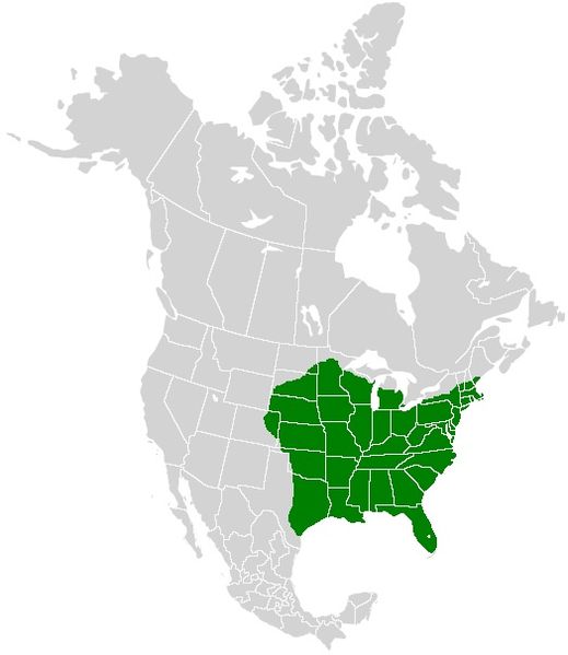
| Tigtulidong | A range map showing the distribution of the Eastern Tiger Swallowtail (Papilio glaucus) |
| Petsa | (UTC) |
| Ginkuhaan | |
| Awtor |
|
| This is a retouched picture, which means that it has been digitally altered from its original version. Modifications: I added color to show the range of the Eastern Tiger Swallowtail. The original can be viewed here: North America second level political division 2.svg:
|
I, the copyright holder of this work, hereby publish it under the following license:
This file is licensed under the Creative Commons Attribution-Share Alike 2.5 Generic license.
- Talwas ka:
- para han pagpasaro – para han pagkopya, pagpakalat ngan pagpadangat han buhat
- para han pagremix – pag-adapt han buhat
- Ha ilarom an masunod nga mga kondisyon:
- attribution – Kinahanglanon mo tagan hin kaangayan nga credit, paghatag hin sumpay ngadto ha lisensya, ngan igbutang an imo ginbag-ohan nga binuhat. Puydi mo ini buhaton ha bisan ano nga resonable nga pamaagi, pero diri nimo pagawson nga an naghatag hin lisensya nag-eendorso ha imo o ha imo paggamit.
- share alike – Kun imo ginsagol-hin-otro, gin-iba, o gin-hingayad han buhat, ikaw in angay gud là magpakalat han imo gin-amot ha ilarom la han [http:creativecommons.org/share-your-work/licensing-considerations/compatible-licenses pareho o naangay nga lisensya] sugad han orihinal.
Original upload log
This image is a derivative work of the following images:
- File:North_America_second_level_political_division_2.svg licensed with Cc-by-sa-2.5, Cc-by-sa-2.5
- 2007-12-08T23:23:36Z Lokal Profil 1712x1992 (335351 Bytes) Code cleanup
- 2007-10-07T07:55:13Z AlexCovarrubias 1712x1992 (350437 Bytes) == Summary == {{Information |Description=Map of North America and its second-level political divisions. Canadian provinces, US and Mexican states. Canada, Mexico, United States. |Source=Canada and US map by Alan Rockefeller.
Uploaded with derivativeFX
Kaagi han paypay
Pidlita an adlaw/oras para makit-an an fayl nga naggawas hito nga oras.
| Pitsa/Oras | Thumbnail | Mga dimensyon | Gumaramit | Komento | |
|---|---|---|---|---|---|
| waray pa kasasapawi | 22:11, 20 Enero 2011 | | 524 × 605 (51 nga KB) | Meganmccarty | Removed range from Mexico and southern tip of Florida. Papilio glaucus is not found in these areas. P. alexiares replaces P. glaucus in Mexico. |
| 18:41, 31 Disyembre 2008 |  | 531 × 613 (26 nga KB) | Meganmccarty | {{Information |Description={{en|Map of North America and its second-level political divisions. Canadian provinces, US and Mexican states. Canada, Mexico, United States. Non-contiguous parts of a states/provinces are "grouped" together with the main area |
Mga Sumpay
An mga nasunod nga mga pakli nasumpay hini nga paypay:
Global file usage
An masunod nga iba nga mga wiki in nagamit hini nga file:
- Paggamit ha arz.wikipedia.org
- Paggamit ha bg.wikipedia.org
- Paggamit ha ceb.wikipedia.org
- Paggamit ha cy.wikipedia.org
- Paggamit ha de.wikipedia.org
- Paggamit ha en.wikipedia.org
- Paggamit ha fr.wikipedia.org
- Paggamit ha gd.wiktionary.org
- Paggamit ha it.wikipedia.org
- Paggamit ha ml.wikipedia.org
- Paggamit ha nl.wikipedia.org
- Paggamit ha ru.wikipedia.org
- Paggamit ha sv.wikipedia.org
- Paggamit ha vi.wikipedia.org
- Paggamit ha www.wikidata.org
- Paggamit ha zh.wikipedia.org