
Paypay:Ph SOCCSKSARGEN.png
Waray mas hiruhitaas nga resolusyon.
Ph_SOCCSKSARGEN.png (361 × 490 nga pixel, kadako han fayl: 28 nga KB, MIME nga tipo: image/png)

|
This map image could be re-created using vector graphics as an SVG file. This has several advantages; see Commons:Media for cleanup for more information. If an SVG form of this image is available, please upload it and afterwards replace this template with
{{vector version available|new image name}}.
It is recommended to name the SVG file “Ph SOCCSKSARGEN.svg”—then the template Vector version available (or Vva) does not need the new image name parameter. |
Dalikyat nga pulong
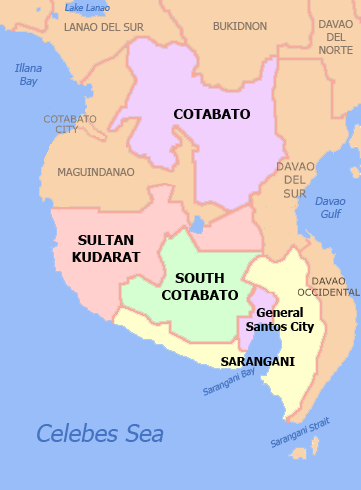
| Tigtulidong | Political Map of SOCCSKSARGEN Region, Philippines. Showing Cotabato, Sarangani, South Cotabato, Sultan Kudarat, Cotabato City and General Santos City. Used the map template :Image:BlankMap-Philippines.png by User:TheCoffee. |
| Petsa | 3 Mayo 2007 (original upload date) |
| Ginkuhaan | Kalugaringon nga buhat |
| Awtor | Namayan at English Wikipedia |
Palilisensya:
Namayan at English Wikipedia, the copyright holder of this work, hereby publishes it under the following licenses:

|
An permiso in ginhatag ha pagkopya, pagpakalat ngan/o pagliwat hinin nga dokumento ha ilarom han mga termino han GNU Free Documentation License, Version 1.2 o mas uruurhi nga version nga ginmantala han Free Software Foundation; nga may-ada waray Invariant Sections, waray Front-Cover Texts, ngan waray Back-Cover Texts. May-ada kopya hin lisensya nga ginlalakip ha seksyon nga may-ada pamagat nga GNU Free Documentation License. |
| Ini nga file in nakalisensya ha ilarom han Creative Commons Attribution-Share Alike 3.0 Unported license. | ||
| Attribution: Namayan at English Wikipedia | ||
| ||
| This licensing tag was added to this file as part of the GFDL licensing update. |
This file is licensed under the Creative Commons Attribution 2.5 Generic license.
Attribution: Namayan at English Wikipedia
- Talwas ka:
- para han pagpasaro – para han pagkopya, pagpakalat ngan pagpadangat han buhat
- para han pagremix – pag-adapt han buhat
- Ha ilarom an masunod nga mga kondisyon:
- attribution – Kinahanglanon mo tagan hin kaangayan nga credit, paghatag hin sumpay ngadto ha lisensya, ngan igbutang an imo ginbag-ohan nga binuhat. Puydi mo ini buhaton ha bisan ano nga resonable nga pamaagi, pero diri nimo pagawson nga an naghatag hin lisensya nag-eendorso ha imo o ha imo paggamit.
Puydi ka pumili hin lisenysa nga karuyag mo.
Original upload log
The original description page was here. All following user names refer to en.wikipedia.
- 2007-05-03 13:30 Namayan 361×490 (34166 bytes) adjusted gensan label
- 2010-10-22 11:45 JL 09 361×490 (24970 bytes) Shariff Kabunsuan is no longer a province since 2008.
Kaagi han paypay
Pidlita an adlaw/oras para makit-an an fayl nga naggawas hito nga oras.
| Pitsa/Oras | Thumbnail | Mga dimensyon | Gumaramit | Komento | |
|---|---|---|---|---|---|
| waray pa kasasapawi | 04:46, 26 Nobyembre 2021 | | 361 × 490 (28 nga KB) | Hariboneagle927 | Reverted to version as of 06:22, 5 September 2021 (UTC) |
| 03:48, 26 Nobyembre 2021 |  | 2,000 × 2,768 (429 nga KB) | Nissan2020 | Reverted to version as of 11:35, 28 March 2021 (UTC) | |
| 06:22, 5 Septyembre 2021 |  | 361 × 490 (28 nga KB) | Emperor1991z | Reverted to version as of 17:10, 26 January 2019 (UTC) | |
| 08:56, 30 Marso 2021 |  | 361 × 490 (24 nga KB) | HueMan1 | Reverted to version as of 10:55, 27 January 2019 (UTC) | |
| 11:35, 28 Marso 2021 |  | 2,000 × 2,768 (429 nga KB) | Teamayuiyui | Update from 2021 | |
| 10:55, 27 Enero 2019 |  | 361 × 490 (24 nga KB) | Hariboneagle927 | Reverted to version as of 03:41, 7 December 2012 (UTC) | |
| 17:10, 26 Enero 2019 |  | 361 × 490 (28 nga KB) | Hariboneagle927 | Update. Cotabato City no longer part of the region. Plus Dav. Occidental borders outside the region. | |
| 03:41, 7 Disyembre 2012 |  | 361 × 490 (24 nga KB) | OgreBot | (BOT): Reverting to most recent version before archival | |
| 03:41, 7 Disyembre 2012 |  | 361 × 490 (33 nga KB) | OgreBot | (BOT): Uploading old version of file from en.wikipedia; originally uploaded on 2007-05-03 13:30:03 by Namayan | |
| 12:32, 6 Disyembre 2012 |  | 361 × 490 (24 nga KB) | MGA73bot2 | {{BotMoveToCommons|en.wikipedia|year={{subst:CURRENTYEAR}}|month={{subst:CURRENTMONTHNAME}}|day={{subst:CURRENTDAY}}}} == {{int:filedesc}} == {{Information |description=Political Map of SOCCSKSARGEN Region, [[:en:Philippines|Phili... |
Mga Sumpay
Waray pakli nga nagamit hinin nga file.
Global file usage
An masunod nga iba nga mga wiki in nagamit hini nga file:
- Paggamit ha cbk-zam.wikipedia.org