
Paypay:Pyrenees topographic map-en.svg

Size of this PNG preview of this SVG file: 800 × 475 nga mga pixel. Iba nga mga resolusyon: 320 × 190 nga mga pixel | 640 × 380 nga mga pixel | 1,024 × 608 nga mga pixel | 1,280 × 760 nga mga pixel | 2,560 × 1,520 nga mga pixel | 3,200 × 1,900 nga mga pixel.
Orihinal nga paypay (SVG nga fayl, ginbabanabanahan nga 3,200 × 1,900 nga mga pixel, kadako han fayl: 6.3 nga MB)
| Tigtulidong |
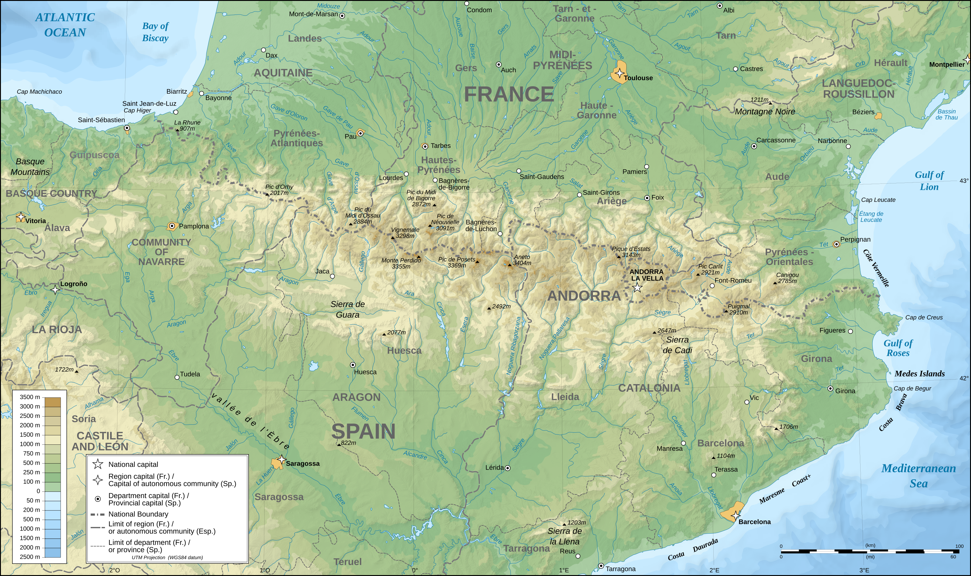
English: Topographic map in English of the Pyrenees Mountains. Note: The shaded relief is a raster image embedded in the SVG file. Français : Carte topographique des Pyrénées en english.
UTM projection; WGS84 datum; shaded relief (composite image of N-W, W and N lightning positions);Note : Le relief ombré est une image bitmap embarquée dans le fichier SVG. *The approximate horizontal accuracy of topographic data and shore/lakes limits is 1,125 m (per pixel). This map should not be printed over a 1:1 ratio (27.09 x 16.09cm), which corresponds to a scale of 1:2,010,221. *Approximate scale of the bathymetry: 1:7,708,000 (precision: 1,927 m) |
| Petsa | (UTC) |
| Ginkuhaan | |
| Awtor |
|
| This is a retouched picture, which means that it has been digitally altered from its original version. Modifications: translation into English. The original can be viewed here: Pyrenees topographic map-fr.svg:
|
I, the copyright holder of this work, hereby publish it under the following licenses:
This file is licensed under the Creative Commons Attribution-Share Alike 2.5 Generic, 2.0 Generic and 1.0 Generic license.
- Talwas ka:
- para han pagpasaro – para han pagkopya, pagpakalat ngan pagpadangat han buhat
- para han pagremix – pag-adapt han buhat
- Ha ilarom an masunod nga mga kondisyon:
- attribution – Kinahanglanon mo tagan hin kaangayan nga credit, paghatag hin sumpay ngadto ha lisensya, ngan igbutang an imo ginbag-ohan nga binuhat. Puydi mo ini buhaton ha bisan ano nga resonable nga pamaagi, pero diri nimo pagawson nga an naghatag hin lisensya nag-eendorso ha imo o ha imo paggamit.
- share alike – Kun imo ginsagol-hin-otro, gin-iba, o gin-hingayad han buhat, ikaw in angay gud là magpakalat han imo gin-amot ha ilarom la han [http:creativecommons.org/share-your-work/licensing-considerations/compatible-licenses pareho o naangay nga lisensya] sugad han orihinal.
| Ini nga file in nakalisensya ha ilarom han Creative Commons Attribution-Share Alike 3.0 Unported license. | ||
| ||
| This licensing tag was added to this file as part of the GFDL licensing update. |

|
An permiso in ginhatag ha pagkopya, pagpakalat ngan/o pagliwat hinin nga dokumento ha ilarom han mga termino han GNU Free Documentation License, Version 1.2 o mas uruurhi nga version nga ginmantala han Free Software Foundation; nga may-ada waray Invariant Sections, waray Front-Cover Texts, ngan waray Back-Cover Texts. May-ada kopya hin lisensya nga ginlalakip ha seksyon nga may-ada pamagat nga GNU Free Documentation License. |
Puydi ka pumili hin lisenysa nga karuyag mo.
Original upload log
This image is a derivative work of the following images:
- File:Pyrenees_topographic_map-fr.svg licensed with Cc-by-sa-2.5,2.0,1.0, Cc-by-sa-3.0-migrated, GFDL
- 2008-09-23T15:49:03Z Sting 3200x1900 (6608359 Bytes) Using ETOPO1 data for bathymetry; new standard colors
- 2007-07-02T00:25:17Z Sting 3200x1900 (6191391 Bytes) + projection info in key ; + major cities areas ; some corrections in the rivers
- 2007-06-25T20:30:25Z Sting 3200x1900 (6166321 Bytes) + key for borders
- 2007-05-31T21:18:03Z Sting 3200x1900 (6163256 Bytes) Some corrections
- 2007-05-30T18:23:51Z Sting 3200x1900 (6163275 Bytes) {{Information |Description=Topographic map in French of the [[:en:Pyrenees|Pyrenees mountains]] |Source=Own work ;Topographic map : [http://www2.jpl.nasa.gov/srtm NASA Shuttle Radar Topography Mission] (SRTM3 v.2) (public dom
Kaagi han paypay
Pidlita an adlaw/oras para makit-an an fayl nga naggawas hito nga oras.
| Pitsa/Oras | Thumbnail | Mga dimensyon | Gumaramit | Komento | |
|---|---|---|---|---|---|
| waray pa kasasapawi | 00:25, 28 Mayo 2011 | | 3,200 × 1,900 (6.3 nga MB) | RedWolf | {{Information |Description={{en|Topographic map in English of the Pyrenees mountains.<br/>''Note:'' The shaded relief is a raster image embedded in the SVG file.}} {{fr|Carte topographique des Pyrénées en english.<br/ |
Mga Sumpay
An mga nasunod nga mga pakli nasumpay hini nga paypay:
Global file usage
An masunod nga iba nga mga wiki in nagamit hini nga file:
- Paggamit ha am.wikipedia.org
- Paggamit ha ar.wikipedia.org
- Paggamit ha bg.wikipedia.org
- Paggamit ha bh.wikipedia.org
- Paggamit ha bn.wikipedia.org
- Paggamit ha ca.wikipedia.org
- Paggamit ha ceb.wikipedia.org
- Paggamit ha cs.wikipedia.org
- Paggamit ha da.wikipedia.org
- Paggamit ha en.wikipedia.org
- Pyrenees
- Col du Tourmalet
- Canigou
- Aneto
- Pic du Midi de Bigorre
- Pre-Pyrenees
- Vignemale
- Monte Perdido
- Pic du Midi d'Ossau
- Montsec Range
- Larrun
- Pica d'Estats
- Col d'Aubisque
- Mallos de Riglos
- Collarada
- Pla d'Adet
- Mount Baigura
- Balaïtous
- Col d'Ares
- Col d'Aspin
- Pic Long
- Corbières Massif
- Hautza
- La Mongie
- Pic del Port Vell
- Pic de Sanfonts
- Port de Pailhères
- Port de Balès
- Col de Portet d'Aspet
- Col de Menté
- Col de Peyresourde
- Port de Larrau
- Col de Port
- Col de Marie-Blanque
- Puigmal
- Pic Ramougn
- Soum de Ramond
Kitaa durudamo nga global usage hinin nga file.