
Paypay:Romania location map.svg

Size of this PNG preview of this SVG file: 800 × 572 nga mga pixel. Iba nga mga resolusyon: 320 × 229 nga mga pixel | 640 × 458 nga mga pixel | 1,024 × 732 nga mga pixel | 1,280 × 915 nga mga pixel | 2,560 × 1,831 nga mga pixel | 1,611 × 1,152 nga mga pixel.
Orihinal nga paypay (SVG nga fayl, ginbabanabanahan nga 1,611 × 1,152 nga mga pixel, kadako han fayl: 194 nga KB)
Dalikyat nga pulong
| Tigtulidong |
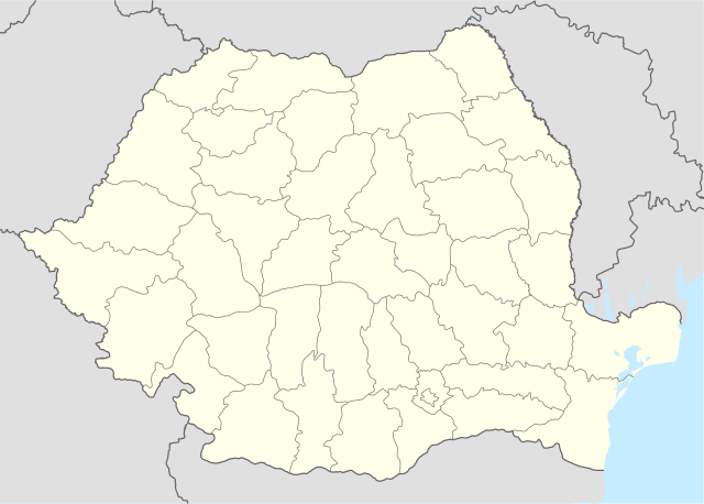
Deutsch: Positionskarte von Rumänien
Quadratische Plattkarte, N-S-Streckung 140 %. Geographische Begrenzung der Karte:
English: Location map of Romania
Equirectangular projection, N/S stretching 140 %. Geographic limits of the map:
|
| Petsa | |
| Ginkuhaan | own work, using United States National Imagery and Mapping Agency data |
| Awtor | NordNordWest |
| Other versions |
|


|
This map has been made or improved in the German Kartenwerkstatt (Map Lab). You can propose maps to improve as well.
|
Palilisensya:
I, the copyright holder of this work, hereby publish it under the following licenses:

|
An permiso in ginhatag ha pagkopya, pagpakalat ngan/o pagliwat hinin nga dokumento ha ilarom han mga termino han GNU Free Documentation License, Version 1.2 o mas uruurhi nga version nga ginmantala han Free Software Foundation; nga may-ada waray Invariant Sections, waray Front-Cover Texts, ngan waray Back-Cover Texts. May-ada kopya hin lisensya nga ginlalakip ha seksyon nga may-ada pamagat nga GNU Free Documentation License. |
Ini nga file in nakalisensya ha ilarom han Creative Commons Attribution-Share Alike 3.0 Unported license.
- Talwas ka:
- para han pagpasaro – para han pagkopya, pagpakalat ngan pagpadangat han buhat
- para han pagremix – pag-adapt han buhat
- Ha ilarom an masunod nga mga kondisyon:
- attribution – Kinahanglanon mo tagan hin kaangayan nga credit, paghatag hin sumpay ngadto ha lisensya, ngan igbutang an imo ginbag-ohan nga binuhat. Puydi mo ini buhaton ha bisan ano nga resonable nga pamaagi, pero diri nimo pagawson nga an naghatag hin lisensya nag-eendorso ha imo o ha imo paggamit.
- share alike – Kun imo ginsagol-hin-otro, gin-iba, o gin-hingayad han buhat, ikaw in angay gud là magpakalat han imo gin-amot ha ilarom la han [http:creativecommons.org/share-your-work/licensing-considerations/compatible-licenses pareho o naangay nga lisensya] sugad han orihinal.
Puydi ka pumili hin lisenysa nga karuyag mo.
Kaagi han paypay
Pidlita an adlaw/oras para makit-an an fayl nga naggawas hito nga oras.
| Pitsa/Oras | Thumbnail | Mga dimensyon | Gumaramit | Komento | |
|---|---|---|---|---|---|
| waray pa kasasapawi | 21:51, 5 Marso 2022 | | 1,611 × 1,152 (194 nga KB) | Flagvisioner | Reverted to version as of 11:40, 6 June 2019 (UTC) |
| 05:54, 22 Pebrero 2022 |  | 1,611 × 1,152 (409 nga KB) | Turbo Slayer 2021 | Coastline | |
| 11:40, 6 Hunyo 2019 |  | 1,611 × 1,152 (194 nga KB) | RHaworth | Smaller version. The larger version is not "very accurate": it just contains 200k bytes of spurious precision. | |
| 12:31, 2 Oktubre 2012 |  | 1,611 × 1,152 (409 nga KB) | Palosirkka | Reverted to version as of 17:18, 5 September 2008 Location maps must remain very accurate | |
| 11:13, 2 Oktubre 2012 |  | 1,611 × 1,152 (203 nga KB) | Palosirkka | Scrubbed with http://codedread.com/scour/ | |
| 17:18, 5 Septyembre 2008 |  | 1,611 × 1,152 (409 nga KB) | NordNordWest | ||
| 08:52, 2 Septyembre 2008 |  | 1,611 × 1,152 (408 nga KB) | NordNordWest | ||
| 15:48, 7 Hulyo 2008 |  | 806 × 576 (386 nga KB) | NordNordWest | {{Information |Description= {{de|Positionskarte von Rumänien}} Quadratische Plattkarte, N-S-Streckung 140 %. Geographische Begrenzung der Karte: * N: 48.5° N * S: 43.4° N * W: 20.0° O * O: 30.0° O {{en|Location map of [[:en:Romania| |
Mga Sumpay
An mga nasunod nga mga pakli nasumpay hini nga paypay:
Global file usage
An masunod nga iba nga mga wiki in nagamit hini nga file:
- Paggamit ha af.wikipedia.org
- Paggamit ha als.wikipedia.org
- Paggamit ha an.wikipedia.org
- Paggamit ha ar.wikipedia.org
- Paggamit ha ast.wikipedia.org
Kitaa durudamo nga global usage hinin nga file.