
Paypay:Morina ruins.jpg

Kadako hin nga pahiuna nga pagawas: 800 × 538 nga mga pixel. Iba nga mga resolusyon: 320 × 215 nga mga pixel | 640 × 431 nga mga pixel | 1,024 × 689 nga mga pixel | 1,280 × 862 nga mga pixel | 2,560 × 1,723 nga mga pixel | 5,246 × 3,531 nga mga pixel.
Orihinal nga paypay (5,246 × 3,531 nga pixel, kadako han fayl: 12.93 nga MB, MIME nga tipo: image/jpeg)
Dalikyat nga pulong
| Tigtulidong |
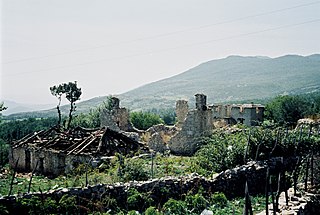
English: Ruins near Morina in the White Drin valley, at the border between Albania and Kosovo. A nearby village is called Planeja, the mountain to the right is called Pastrik. Taken in summer 2001 from a KFOR tank.
These buildings may have been destroyed in the attack, mentioned in the following quote: FOREIGN & COMMONWEALTH OFFICE, LONDON, JUNE 1999 23-24 May |
||
| Petsa | |||
| Ginkuhaan | Kalugaringon nga buhat | ||
| Awtor |
|
| Camera location | | View this and other nearby images on: OpenStreetMap |
|---|
I, the copyright holder of this work, hereby publish it under the following licenses:

|
An permiso in ginhatag ha pagkopya, pagpakalat ngan/o pagliwat hinin nga dokumento ha ilarom han mga termino han GNU Free Documentation License, Version 1.2 o mas uruurhi nga version nga ginmantala han Free Software Foundation; nga may-ada waray Invariant Sections, waray Front-Cover Texts, ngan waray Back-Cover Texts. May-ada kopya hin lisensya nga ginlalakip ha seksyon nga may-ada pamagat nga GNU Free Documentation License. |
This file is licensed under the Creative Commons Attribution 3.0 Unported license.
- Talwas ka:
- para han pagpasaro – para han pagkopya, pagpakalat ngan pagpadangat han buhat
- para han pagremix – pag-adapt han buhat
- Ha ilarom an masunod nga mga kondisyon:
- attribution – Kinahanglanon mo tagan hin kaangayan nga credit, paghatag hin sumpay ngadto ha lisensya, ngan igbutang an imo ginbag-ohan nga binuhat. Puydi mo ini buhaton ha bisan ano nga resonable nga pamaagi, pero diri nimo pagawson nga an naghatag hin lisensya nag-eendorso ha imo o ha imo paggamit.
Puydi ka pumili hin lisenysa nga karuyag mo.
Kaagi han paypay
Pidlita an adlaw/oras para makit-an an fayl nga naggawas hito nga oras.
| Pitsa/Oras | Thumbnail | Mga dimensyon | Gumaramit | Komento | |
|---|---|---|---|---|---|
| waray pa kasasapawi | 14:11, 7 Marso 2010 | | 5,246 × 3,531 (12.93 nga MB) | Watchduck | Reverted to version as of 16:04, 13 December 2009 |
| 20:48, 14 Disyembre 2009 |  | 5,163 × 3,431 (12.44 nga MB) | Watchduck | color correction | |
| 16:04, 13 Disyembre 2009 |  | 5,246 × 3,531 (12.93 nga MB) | Watchduck | There was a black border rest on the left side. | |
| 15:57, 13 Disyembre 2009 |  | 5,258 × 3,531 (12.45 nga MB) | Watchduck | {{Information |Description={{en|1=Ruins near Morina in the White Drin valley, at the border between Albania and Kosovo. Taken in summer 2001 from a KFOR tank.}} |Source={{own}} |Author=[[U |
Mga Sumpay
Waray pakli nga nagamit hinin nga file.
Global file usage
An masunod nga iba nga mga wiki in nagamit hini nga file:
- Paggamit ha cs.wikipedia.org
- Paggamit ha de.wikipedia.org
- Paggamit ha en.wikipedia.org
- Paggamit ha en.wikiversity.org
- Paggamit ha fr.wikipedia.org
- Paggamit ha id.wikipedia.org
- Paggamit ha pl.wikipedia.org
- Paggamit ha pt.wikipedia.org
- Paggamit ha ru.wikipedia.org
- Paggamit ha sh.wikipedia.org
- Paggamit ha sq.wikipedia.org
- Paggamit ha sr.wikipedia.org
- Paggamit ha te.wiktionary.org
- Paggamit ha www.wikidata.org
- Paggamit ha zh.wikipedia.org