
Paypay:Rote Flüh von Haldensee.jpg

Kadako hin nga pahiuna nga pagawas: 800 × 523 nga mga pixel. Iba nga mga resolusyon: 320 × 209 nga mga pixel | 640 × 418 nga mga pixel | 1,024 × 669 nga mga pixel | 1,280 × 836 nga mga pixel | 2,828 × 1,848 nga mga pixel.
Orihinal nga paypay (2,828 × 1,848 nga pixel, kadako han fayl: 3.41 nga MB, MIME nga tipo: image/jpeg)
Dalikyat nga pulong
| Tigtulidong |
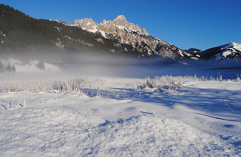
Deutsch: Die Rote Flüh und mehrere andere Berge, betrachtet von Westen über den in Bodennebel getauchten Haldensee (Tannheimer Tal, Tirol, Österreich).
English: The Rote Flüh and several other mountains seen from west over the Haldensee (Grän, Tyrol, Austria), which is dipped in ground fog.
Français : Le Rote Flüh, qui fait partie des Alpes d'Allgäu, et plusieurs autres montagnes vues depuis l'ouest, derrière le lac d'Haldensee qui est caché dans le brouillard. Photo prise près de Grän, dans le Tyrol en Autriche.
This photograph was taken with a Nikon D3000 |
| Petsa | |
| Ginkuhaan | Kalugaringon nga buhat |
| Awtor | kaʁstn Disk/Cat |
| Pagtugot (Gin-uutro paggamit inin nga file) |
Carschten, the copyright holder of this work, hereby publishes it under the following license: This file is licensed under the Creative Commons Attribution-Share Alike 3.0 Germany license. Attribution: Carschten
 |
| Camera location | | View this and other nearby images on: OpenStreetMap |
|---|
| Camera Model | Nikon D3000 |
|---|---|
| Shutter speed | 1/320s |
| Aperture | F9.0 |
| Film speed (ISO) | 100 |
| Focal length | 18mm |
Palilisensya:
Carschten, the copyright holder of this work, hereby publishes it under the following license:
This file is licensed under the Creative Commons Attribution-Share Alike 3.0 Germany license.
Attribution: Carschten
- Talwas ka:
- para han pagpasaro – para han pagkopya, pagpakalat ngan pagpadangat han buhat
- para han pagremix – pag-adapt han buhat
- Ha ilarom an masunod nga mga kondisyon:
- attribution – Kinahanglanon mo tagan hin kaangayan nga credit, paghatag hin sumpay ngadto ha lisensya, ngan igbutang an imo ginbag-ohan nga binuhat. Puydi mo ini buhaton ha bisan ano nga resonable nga pamaagi, pero diri nimo pagawson nga an naghatag hin lisensya nag-eendorso ha imo o ha imo paggamit.
- share alike – Kun imo ginsagol-hin-otro, gin-iba, o gin-hingayad han buhat, ikaw in angay gud là magpakalat han imo gin-amot ha ilarom la han [http:creativecommons.org/share-your-work/licensing-considerations/compatible-licenses pareho o naangay nga lisensya] sugad han orihinal.
Assessment
|
This image was selected as picture of the day on Wikimedia Commons for 25 June 2011. It was captioned as follows: English: The Rote Flüh and several other mountains seen from west over the Haldensee (Grän, Tyrol, Austria), which is dipped in ground fog. Other languages:
Deutsch: Die Rote Flüh und mehrere andere Berge, betrachtet über den in Bodennebel getauchten Haldensee (Grän, Tirol, Österreich). English: The Rote Flüh and several other mountains seen from west over the Haldensee (Grän, Tyrol, Austria), which is dipped in ground fog. Español: El Rote Flüh y otros picos vistos desde el oeste sobre el Haldensee (Grän, Tirol, Austria), que aparece hundido en niebla baja. Esperanto: La monto Rote Flüh kaj pluraj aliaj, vidataj de okcidento malantaŭ la lago Haldensee, mem vualata en nebulo, en Tirolo, Aŭstrio Français : Le Rote Flüh, qui fait partie des Alpes d'Allgäu, et plusieurs autres montagnes vues depuis l'ouest, derrière le lac d'Haldensee qui est caché dans le brouillard. Photo prise près de Grän, dans le Tyrol en Autriche. Italiano: Il Rote Flüh e diverse altre montagne viste dall'occidente sull'Haldensee (Grän, Tirolo, Austria), avvolto nella foschia. Nederlands: De Rote Flüh en enkele andere bergtoppen gezien vanuit het westen over de grondmist van de Haldensee in het Oostenrijkse Tirol. Русский: Роте-Флю и другие горы с запада озера Хальдензее (Тироль) над утренним туманом. Українська: Роте Флю (нім. Rote Flüh — Червона (прямовисна) Скеля) та інші гори на західному березі озера Хальдензеє занурені в ранковий туман, Альгейські Альпи, Тіроль, Австрія 日本語: Rote Flüh などの山々を西から、地表の霧に隠れる Haldensee 湖(オーストリア チロル州グレン)の向こうに望む。 中文: 北莱姆斯通阿尔卑斯山脉阿尔高山脉的罗特弗吕山和其他山,地面笼罩着雾。 |
Kaagi han paypay
Pidlita an adlaw/oras para makit-an an fayl nga naggawas hito nga oras.
| Pitsa/Oras | Thumbnail | Mga dimensyon | Gumaramit | Komento | |
|---|---|---|---|---|---|
| waray pa kasasapawi | 12:55, 22 Enero 2011 | | 2,828 × 1,848 (3.41 nga MB) | Carschten | new |
| 21:10, 21 Enero 2011 |  | 3,000 × 1,980 (3.7 nga MB) | Carschten | {{subst:User:Carschten/pic | Beschreibung = {{de|Blick über den in leichten Bodennebel getauchten Haldensee Richtung des Berges Rote Flüh}} | Datum = 2011-01-01 | Lizenz = | 360° |
Mga Sumpay
Waray pakli nga nagamit hinin nga file.
Global file usage
An masunod nga iba nga mga wiki in nagamit hini nga file:
- Paggamit ha ba.wikipedia.org
- Paggamit ha be-tarask.wikipedia.org
- Paggamit ha bn.wikipedia.org
- Paggamit ha crh.wikipedia.org
- Paggamit ha cv.wikipedia.org
- Paggamit ha de.wikipedia.org
- Paggamit ha en.wikipedia.org
- Paggamit ha hu.wikipedia.org
- Paggamit ha id.wikipedia.org
- Paggamit ha kk.wikipedia.org
- Paggamit ha ko.wikipedia.org
- Paggamit ha lbe.wikipedia.org
- Paggamit ha nl.wikipedia.org
- Paggamit ha os.wikipedia.org
- Paggamit ha pl.wikipedia.org
- Paggamit ha pt.wikipedia.org
- Paggamit ha ru.wikipedia.org
- Paggamit ha ru.wikinews.org
- Paggamit ha sah.wikipedia.org
- Paggamit ha sv.wikipedia.org
- Paggamit ha uk.wikipedia.org
- Paggamit ha vi.wikipedia.org
- Paggamit ha xal.wikipedia.org
- Paggamit ha zh.wikipedia.org