
Paypay:After Hama Massacre.jpg
Kadako hin nga pahiuna nga pagawas: 589 × 600 nga mga pixel. Iba nga mga resolusyon: 236 × 240 nga mga pixel | 607 × 618 nga mga pixel.
Orihinal nga paypay (607 × 618 nga pixel, kadako han fayl: 241 nga KB, MIME nga tipo: image/jpeg)
Dalikyat nga pulong
| Tigtulidong |
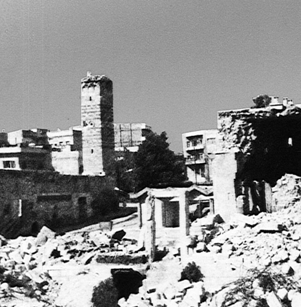
English: Image of Hama after Massacre in 1982, the compliment image of "Before Hama Massacre." Photograph shows the destroyed Al-Nuri Mosque, on the western bank of the Orontes River, next to the Hama Castle.
العربية: صورة لحماة بعد مجزرة عام 1982 |
| Ginkuhaan | http://lcweb2.loc.gov/cgi-bin/query/r?frd/cstdy:@field(DOCID+sy0027) "Library of Congress:A Country Study, Syria" |
| Awtor | Library of Congress |
| Pagtugot (Gin-uutro paggamit inin nga file) |
US federal government in Public Domain |
| Other versions |
 |
| Camera location | | View this and other nearby images on: OpenStreetMap |
|---|
Palilisensya:
This work is in the public domain in the United States because it is a work prepared by an officer or employee of the United States Government as part of that person’s official duties under the terms of Title 17, Chapter 1, Section 105 of the US Code.
Note: This only applies to original works of the Federal Government and not to the work of any individual U.S. state, territory, commonwealth, county, municipality, or any other subdivision. This template also does not apply to postage stamp designs published by the United States Postal Service since 1978. (See § 313.6(C)(1) of Compendium of U.S. Copyright Office Practices). It also does not apply to certain US coins; see The US Mint Terms of Use.
|
 | |
| This file has been identified as being free of known restrictions under copyright law, including all related and neighboring rights. | ||
Original upload log
Transferred from en.wikipedia to Commons by Muhends using CommonsHelper.
The original description page was here. All following user names refer to en.wikipedia.
- 2011-07-22 16:36 Guest2625 607×618 (91633 bytes) {{Information |Description = Image of Hama after Massacre in 1982, the compliment image of "Before Hama Massacre" |Source = http://lcweb2.loc.gov/cgi-bin/query/r?frd/cstdy:@field(DOCID+sy0027) "Library of Congress:A Country Study, Syria" |Da
Kaagi han paypay
Pidlita an adlaw/oras para makit-an an fayl nga naggawas hito nga oras.
| Pitsa/Oras | Thumbnail | Mga dimensyon | Gumaramit | Komento | |
|---|---|---|---|---|---|
| waray pa kasasapawi | 21:40, 3 Abril 2017 | | 607 × 618 (241 nga KB) | MrPenguin20 | Image was reversed. |
| 21:18, 3 Mayo 2012 |  | 607 × 618 (89 nga KB) | File Upload Bot (Magnus Manske) | Transfered from en.wikipedia by User:muhends using CommonsHelper |
Mga Sumpay
An mga nasunod nga mga pakli nasumpay hini nga paypay:
Global file usage
An masunod nga iba nga mga wiki in nagamit hini nga file:
- Paggamit ha ar.wikipedia.org
- Paggamit ha azb.wikipedia.org
- Paggamit ha az.wikipedia.org
- Paggamit ha da.wikipedia.org
- Paggamit ha de.wikipedia.org
- Paggamit ha en.wikipedia.org
- Paggamit ha fa.wikipedia.org
- Paggamit ha fi.wikipedia.org
- Paggamit ha fr.wikipedia.org
- Paggamit ha he.wikipedia.org
- Paggamit ha hy.wikipedia.org
- Paggamit ha it.wikipedia.org
- Paggamit ha ja.wikipedia.org
- Paggamit ha ko.wikipedia.org
- Paggamit ha nn.wikipedia.org
- Paggamit ha no.wikipedia.org
- Paggamit ha pl.wikipedia.org
- Paggamit ha pt.wikipedia.org
- Paggamit ha ru.wikipedia.org
- Paggamit ha sh.wikipedia.org
- Paggamit ha sl.wikipedia.org
- Paggamit ha tr.wikipedia.org
- Paggamit ha uk.wikipedia.org
- Paggamit ha uz.wikipedia.org
- Paggamit ha www.wikidata.org
- Paggamit ha zh.wikipedia.org