
Paypay:Arabian Peninsula dust SeaWiFS-2.jpg

Kadako hin nga pahiuna nga pagawas: 657 × 600 nga mga pixel. Iba nga mga resolusyon: 263 × 240 nga mga pixel | 526 × 480 nga mga pixel | 841 × 768 nga mga pixel | 1,122 × 1,024 nga mga pixel | 2,504 × 2,286 nga mga pixel.
Orihinal nga paypay (2,504 × 2,286 nga pixel, kadako han fayl: 867 nga KB, MIME nga tipo: image/jpeg)
| Tigtulidong |
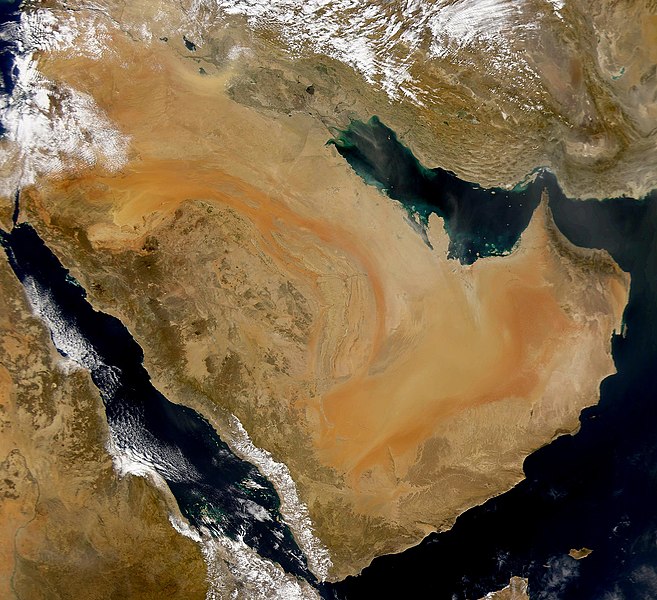
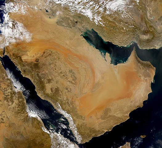
English: SeaWiFS collected this view of the Arabian Peninsula and of dust blowing across the Persian Gulf. Español: La Península Arábiga vista desde el espacio Suomi: Satelliittikuva Arabian niemimaasta
Українська: Компіляція супутникових знімків пилової бурі над Аравійським півостровом, 16 листопада 2008 року. |
| Petsa | (UTC) |
| Ginkuhaan | |
| Awtor |
|
| This is a retouched picture, which means that it has been digitally altered from its original version. Modifications: Enhanced contrast, midtones. The original can be viewed here: Arabian Peninsula dust SeaWiFS.jpg:
|
I, the copyright holder of this work, hereby publish it under the following license:
| This image is from the Sea-viewing Wide Field-of-view Sensor (SeaWiFS) Project and more than 5 years old.
Satellite data captured by the SeaWIFS sensor are released into the public domain 5 years after capture. Data less than five years old can be re-used only for educational or scientific purposes; any commercial use of such images must be coordinated with GeoEye. [1] |
| This work has been released into the public domain by its copyright holder, GeoEye. This applies worldwide. In some countries this may not be legally possible; if so: GeoEye grants anyone the right to use this work for any purpose, without any conditions, unless such conditions are required by law.
|
Original upload log
This image is a derivative work of the following images:
- Image:Arabian_Peninsula_dust_SeaWiFS.jpg licensed with PD-SeaWiFS
- 2008-01-02T17:02:18Z Hautala 2504x2286 (873404 Bytes) {{PD-USGov-NASA}} * {{en|Satellite image of Arabian peninsula}} * {{es|La Península Arábiga vista desde el espacio}} * {{en|Satelliittikuva Arabian niemimaasta}} Taken from NASA's [http://visibleearth.nasa.gov/ Visible E
Uploaded with derivativeFX
Kaagi han paypay
Pidlita an adlaw/oras para makit-an an fayl nga naggawas hito nga oras.
| Pitsa/Oras | Thumbnail | Mga dimensyon | Gumaramit | Komento | |
|---|---|---|---|---|---|
| waray pa kasasapawi | 04:59, 16 Nobyembre 2008 | | 2,504 × 2,286 (867 nga KB) | John Nevard | {{Information |Description={{en|SeaWiFS collected this view of the Arabian Peninsula and of dust blowing across the Persian Gulf.}} {{es|La Península Arábiga vista desde el espacio}} {{en|Satelliittikuva Arabian niemimaasta}} |Source=*[[:Image:Arabian_P |
Mga Sumpay
An mga nasunod nga mga pakli nasumpay hini nga paypay:
Global file usage
An masunod nga iba nga mga wiki in nagamit hini nga file:
- Paggamit ha af.wikipedia.org
- Paggamit ha ang.wikipedia.org
- Paggamit ha ar.wikipedia.org
- Paggamit ha ar.wikiquote.org
- Paggamit ha arz.wikipedia.org
- Paggamit ha awa.wikipedia.org
- Paggamit ha azb.wikipedia.org
- Paggamit ha az.wikipedia.org
- Paggamit ha bcl.wikipedia.org
- Paggamit ha bh.wikipedia.org
- Paggamit ha bn.wikipedia.org
- Paggamit ha ckb.wikipedia.org
- Paggamit ha da.wikipedia.org
- Paggamit ha el.wikipedia.org
- Paggamit ha en.wikipedia.org
- Paggamit ha en.wikibooks.org
- Paggamit ha eo.wikipedia.org
- Paggamit ha es.wikipedia.org
- Paggamit ha fr.wikibooks.org
- Paggamit ha ja.wikipedia.org
- Paggamit ha kab.wikipedia.org
- Paggamit ha ka.wikipedia.org
- Paggamit ha ko.wikipedia.org
- Paggamit ha lb.wikipedia.org
- Paggamit ha mg.wikipedia.org
- Paggamit ha mr.wikipedia.org
- Paggamit ha ms.wikipedia.org
Kitaa durudamo nga global usage hinin nga file.