
Paypay:Archipiélago de Chiloé-blank.PNG

Kadako hin nga pahiuna nga pagawas: 456 × 599 nga mga pixel. Iba nga mga resolusyon: 182 × 240 nga mga pixel | 365 × 480 nga mga pixel | 584 × 768 nga mga pixel | 1,100 × 1,446 nga mga pixel.
Orihinal nga paypay (1,100 × 1,446 nga pixel, kadako han fayl: 1,017 nga KB, MIME nga tipo: image/png)
| Tigtulidong | |||||
| Petsa | |||||
| Ginkuhaan |
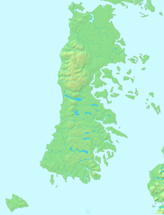
Español: Mapa en el dominio público English: PD map |
||||
| Awtor | Lin linao | ||||
| Pagtugot (Gin-uutro paggamit inin nga file) |
|
Kaagi han paypay
Pidlita an adlaw/oras para makit-an an fayl nga naggawas hito nga oras.
| Pitsa/Oras | Thumbnail | Mga dimensyon | Gumaramit | Komento | |
|---|---|---|---|---|---|
| waray pa kasasapawi | 19:15, 1 Disyembre 2011 | | 1,100 × 1,446 (1,017 nga KB) | Lin linao | Mejora de resolución y corrección de las bahías y fiordos que estaban marcados como cuerpos de agua interior. |
| 16:29, 5 Septyembre 2007 |  | 280 × 369 (21 nga KB) | Lin linao | {{Information |Description={{es|Mapa del Archipiélago de Chiloé (Chile)}} |Source= {{es|Mapa en el dominio público}}{{en|PD map}} |Date=5 de septiembre, 2007 |Author= Lin linao |Permission={{Demis |
Mga Sumpay
An mga nasunod nga mga pakli nasumpay hini nga paypay:
Global file usage
An masunod nga iba nga mga wiki in nagamit hini nga file:
- Paggamit ha ar.wikipedia.org
- قالب:Location map Chiloé
- كنائس تشيلوي
- كنيسة سانتا ماريا دي لوريتو (آتشاو)
- كنيسة كينتشاو
- كنيسة سان فرانثيسكو (كاسترو)
- كنيسة سانتا ماريا دي ريلان
- كنيسة سيدة جراثيا دي نيركون
- كنيسة آلداتشيلدو
- كنيسة إتشواك
- كنيسة ديتيف
- كنيسة بيلوبويي
- كنيسة تشونتشي
- كنيسة كولو
- كنيسة سان خوان باوتيستا (دالكاوي)
- كنيسة سيدة الأحزان (دالكاوي)
- كنيسة تشيلين
- كنيسة كاجواتش
- أرخبيل تشيلوي
- Paggamit ha bg.wikipedia.org
- Paggamit ha br.wikipedia.org
- Paggamit ha ca.wikipedia.org
- Paggamit ha ceb.wikipedia.org
- Paggamit ha cs.wikipedia.org
- Paggamit ha da.wikipedia.org
- Paggamit ha de.wikipedia.org
- Paggamit ha en.wikipedia.org
- Churches of Chiloé
- Chiloé Island
- Ancud
- Trauco
- Chacao Channel
- Curanto
- Gulf of Corcovado
- Gulf of Ancud
- Guafo Island
- Chilote mythology
- Chilotan architecture
- Chiloé Archipelago
- Quinchao Island
- Lemuy Island
- Quemchi
- Licor de oro
- Sirena chilota
- Dalcahue Channel
- Roca Remolinos
- Estero de Castro
- Template:Chiloe Archipelago
- Caulín Bay
- Sea of Chiloé
Kitaa durudamo nga global usage hinin nga file.