
Paypay:Asturias location map.svg

Size of this PNG preview of this SVG file: 512 × 378 nga mga pixel. Iba nga mga resolusyon: 320 × 236 nga mga pixel | 640 × 473 nga mga pixel | 1,024 × 756 nga mga pixel | 1,280 × 945 nga mga pixel | 2,560 × 1,890 nga mga pixel.
Orihinal nga paypay (SVG nga fayl, ginbabanabanahan nga 512 × 378 nga mga pixel, kadako han fayl: 158 nga KB)
| Tigtulidong |
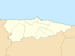
English: Location map of Asturias Equirectangular projection, N/S stretching 130 %. Geographic limits of the map: * N: 44.141° N * S: 42.498° N * W: 7.286° O * E: 4.375° O Español: Mapa de localización de Asturias Proyección equirrectangular, N/S estirada 130 %. Límites geográficos del mapa: * N: 44.141° N * S: 42.498° N * W: 7.286° O * E: 4.375° O |
| Petsa | (UTC) |
| Ginkuhaan | |
| Awtor |
|
| Other versions | Derivative works of this file: Circunscripciones electorales Asturias.svg |
| This is a retouched picture, which means that it has been digitally altered from its original version. Modifications: harmonisation des couleurs. The original can be viewed here: Asturias-loc.svg:
|
I, the copyright holder of this work, hereby publish it under the following license:
Ini nga file in nakalisensya ha ilarom han Creative Commons Attribution-Share Alike 3.0 Unported license.
- Talwas ka:
- para han pagpasaro – para han pagkopya, pagpakalat ngan pagpadangat han buhat
- para han pagremix – pag-adapt han buhat
- Ha ilarom an masunod nga mga kondisyon:
- attribution – Kinahanglanon mo tagan hin kaangayan nga credit, paghatag hin sumpay ngadto ha lisensya, ngan igbutang an imo ginbag-ohan nga binuhat. Puydi mo ini buhaton ha bisan ano nga resonable nga pamaagi, pero diri nimo pagawson nga an naghatag hin lisensya nag-eendorso ha imo o ha imo paggamit.
- share alike – Kun imo ginsagol-hin-otro, gin-iba, o gin-hingayad han buhat, ikaw in angay gud là magpakalat han imo gin-amot ha ilarom la han [http:creativecommons.org/share-your-work/licensing-considerations/compatible-licenses pareho o naangay nga lisensya] sugad han orihinal.
Original upload log
This image is a derivative work of the following images:
- File:Asturias-loc.svg licensed with Cc-by-sa-3.0
- 2010-05-07T11:44:07Z Miguillen 512x378 (272467 Bytes) {{Information |Description=Mapa delocalización del Principado de Asturias |Source={{own}} |Date=2009-05-07 |Author=[[User:Miguillen|Miguillen]] |Permission= |other_versions= }} [[Category:Maps of Asturias]]
Uploaded with derivativeFX
Kaagi han paypay
Pidlita an adlaw/oras para makit-an an fayl nga naggawas hito nga oras.
| Pitsa/Oras | Thumbnail | Mga dimensyon | Gumaramit | Komento | |
|---|---|---|---|---|---|
| waray pa kasasapawi | 11:07, 19 Mayo 2010 | | 512 × 378 (158 nga KB) | Miguillen | borde de costa |
| 09:49, 18 Mayo 2010 |  | 512 × 378 (144 nga KB) | Xfigpower | {{Information |Description={{en|Location map of Asturias}} Equirectangular projection, N/S stretching 130 %. Geographic limits of the map: * N: 44.141° N * S: 42.498° N * W: 7.286° O * E: 4.375° O {{es|Mapa de localización de [ |
Mga Sumpay
An mga nasunod nga mga pakli nasumpay hini nga paypay:
Global file usage
An masunod nga iba nga mga wiki in nagamit hini nga file:
- Paggamit ha ast.wikipedia.org
- Xixón
- Castiello Bernueces (parroquia)
- Valdornón
- Cabueñes
- Caldones (parroquia)
- L'Abadía Cenero
- Deva (parroquia)
- Fano (parroquia)
- Fresno (parroquia)
- Granda (Xixón)
- Samartín de Güerces
- Llavandera (parroquia)
- Llorio
- La Pedrera (parroquia)
- Porceyo
- Puao
- Roces (Xixón)
- Ruedes (parroquia)
- Santurio
- Serín
- Somió
- San Andrés de los Tacones
- Vega (Xixón)
- Veriña
- Xove
- Naves (parroquia de Llanes)
- Cecos
- Santolaya de Vixil
- Zardaín
- Navelgas
- Santolaya de Miñu
- La Puela (parroquia)
- Caborana (parroquia)
- Uxo (parroquia)
- Celoriu (Llanes)
- Universidá d'Uviéu
- Ríu Nalón
- Blimea (parroquia)
- Santa Bárbola
- Bisuyu (Allande)
- Bustantigo (parroquia)
- San Andrés (Trubia)
- Lliberdón (parroquia)
- Cuadonga
- Llastres (parroquia)
- Berducedo (parroquia)
- Llago (parroquia)
- Ḷḷinares (parroquia d'Allande)
- Ḷḷomes (parroquia)
- Paraxes (parroquia)
Kitaa durudamo nga global usage hinin nga file.