
Paypay:Australia Victoria location map highways.svg

Size of this PNG preview of this SVG file: 800 × 563 nga mga pixel. Iba nga mga resolusyon: 320 × 225 nga mga pixel | 640 × 450 nga mga pixel | 1,024 × 720 nga mga pixel | 1,280 × 900 nga mga pixel | 2,560 × 1,800 nga mga pixel | 1,375 × 967 nga mga pixel.
Orihinal nga paypay (SVG nga fayl, ginbabanabanahan nga 1,375 × 967 nga mga pixel, kadako han fayl: 729 nga KB)
| Tigtulidong |
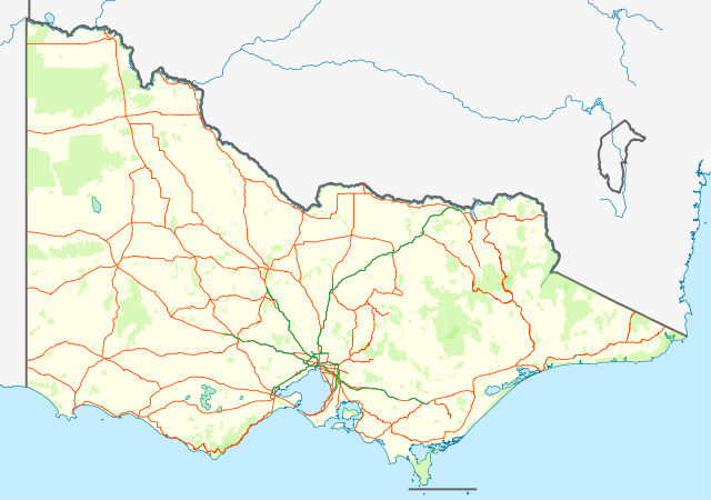
English: Location map with highways (in Orange) and freeways (in Green) of Victoria, Australia. Also shows state forests and national parks.
Equirectangular projection, N/S stretching 124 %. Geographic limits of the map:
Deutsch: Positionskarte mit Highways (Straße zwischen Großstädte; in Orange) and Freeways (~Autobahnen; in Grün) von Victoria, Australien. Auch mit Nationalparks
Quadratische Plattkarte, N-S-Streckung 124 %. Geographische Begrenzung der Karte:
|
| Petsa | (UTC) |
| Ginkuhaan | |
| Awtor |
|
| This is a retouched picture, which means that it has been digitally altered from its original version. Modifications: show roads and national parks. The original can be viewed here: Australia Victoria location map blank.svg:
|
I, the copyright holder of this work, hereby publish it under the following license:
Ini nga file in nakalisensya ha ilarom han Creative Commons Attribution-Share Alike 3.0 Unported license.
- Talwas ka:
- para han pagpasaro – para han pagkopya, pagpakalat ngan pagpadangat han buhat
- para han pagremix – pag-adapt han buhat
- Ha ilarom an masunod nga mga kondisyon:
- attribution – Kinahanglanon mo tagan hin kaangayan nga credit, paghatag hin sumpay ngadto ha lisensya, ngan igbutang an imo ginbag-ohan nga binuhat. Puydi mo ini buhaton ha bisan ano nga resonable nga pamaagi, pero diri nimo pagawson nga an naghatag hin lisensya nag-eendorso ha imo o ha imo paggamit.
- share alike – Kun imo ginsagol-hin-otro, gin-iba, o gin-hingayad han buhat, ikaw in angay gud là magpakalat han imo gin-amot ha ilarom la han [http:creativecommons.org/share-your-work/licensing-considerations/compatible-licenses pareho o naangay nga lisensya] sugad han orihinal.
Original upload log
This image is a derivative work of the following images:
- File:Australia_Victoria_location_map_blank.svg licensed with Cc-by-sa-3.0
- 2010-04-10T01:20:08Z Roke 1375x967 (279504 Bytes) {{Information |Description={{de|Positionskarte von [[:de:Victoria (Australien)|Victoria]], [[:de:Australien|Australien]]}} Quadratische Plattkarte, N-S-Streckung 124 %. Geographische Begrenzung der Karte: * N: 33.8° S * S: 3
Uploaded with derivativeFX
Kaagi han paypay
Pidlita an adlaw/oras para makit-an an fayl nga naggawas hito nga oras.
| Pitsa/Oras | Thumbnail | Mga dimensyon | Gumaramit | Komento | |
|---|---|---|---|---|---|
| waray pa kasasapawi | 13:58, 25 Pebrero 2011 | | 1,375 × 967 (729 nga KB) | Cassowary | {{Information |Description={{en|Location map with highways (in Orange) and freeways (in Green) of Victoria, Australia. Also shows state forests and national parks.}} Equirectangular projection, N/S stretchi |
Mga Sumpay
An mga nasunod nga mga pakli nasumpay hini nga paypay:
Global file usage
An masunod nga iba nga mga wiki in nagamit hini nga file:
- Paggamit ha bs.wikipedia.org
- Paggamit ha ceb.wikipedia.org
- Paggamit ha en.wikipedia.org
- Paggamit ha es.wikipedia.org
- Paggamit ha fa.wikipedia.org
- Paggamit ha kn.wikipedia.org
- Paggamit ha pl.wikipedia.org
- Paggamit ha pl.wikibooks.org
- Paggamit ha shn.wikipedia.org
- Paggamit ha simple.wikipedia.org
- Paggamit ha si.wikipedia.org
- Paggamit ha sl.wikipedia.org
- Paggamit ha tr.wikipedia.org
- Paggamit ha uz.wikipedia.org