
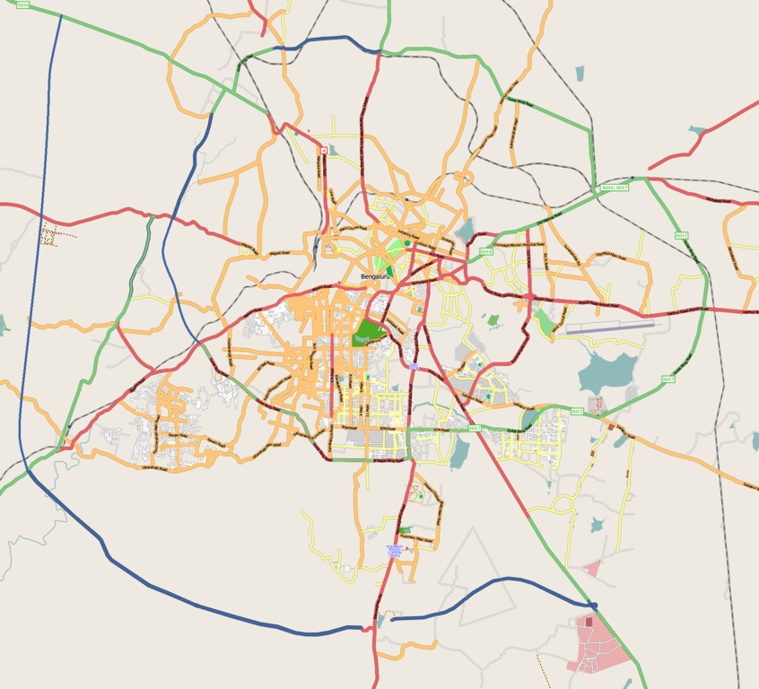
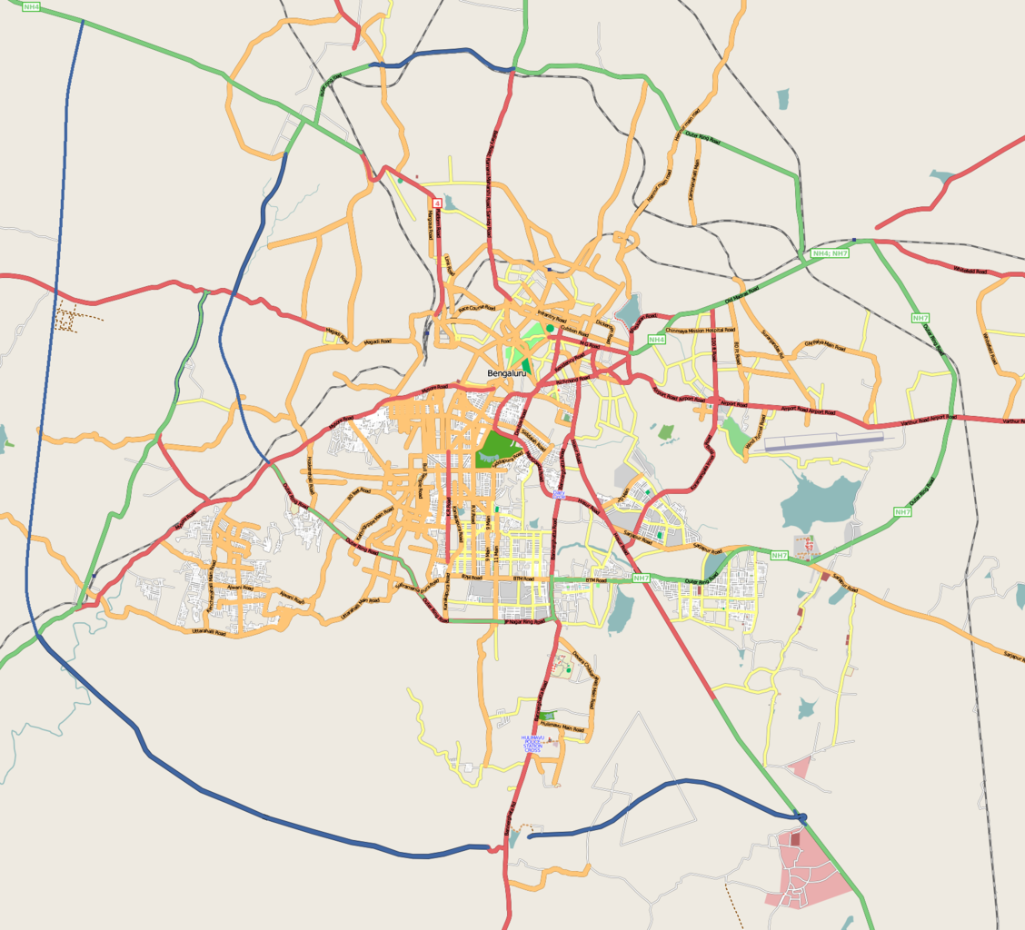
Paypay:Bangalore street Map.png

Kadako hin nga pahiuna nga pagawas: 661 × 600 nga mga pixel. Iba nga mga resolusyon: 264 × 240 nga mga pixel | 529 × 480 nga mga pixel | 846 × 768 nga mga pixel | 1,128 × 1,024 nga mga pixel | 1,722 × 1,563 nga mga pixel.
Orihinal nga paypay (1,722 × 1,563 nga pixel, kadako han fayl: 855 nga KB, MIME nga tipo: image/png)
| Tigtulidong | |
| Petsa |
31 Disyembre 2008 (original upload date) |
| Ginkuhaan | openstreetmap.org |
| Awtor | Collaboratively created by the OpenStreetMap community using only free map sources and manual GPS surveying to build the map from scratch. Raise lkblr grabbed this image from OpenStreetMap |
| Pagtugot (Gin-uutro paggamit inin nga file) |
See OpenStreetMap License for details. |
| Other versions | The 'live' version of this map is available at http://www.openstreetmap.org/?lat=12.9536&lon=77.598&zoom=13 Use the 'export' tab to get a fresh export in a variety of formats, including SVG and '.osm', the underlying geolocated data. Use the 'edit' tab there to edit the map! |
Dalikyat nga pulong
Latitudes from 77.46 to 77.72
Longitude from 12.83 to 13.06
Palilisensya:
This file is licensed under the Creative Commons Attribution 2.0 Generic license.
- Talwas ka:
- para han pagpasaro – para han pagkopya, pagpakalat ngan pagpadangat han buhat
- para han pagremix – pag-adapt han buhat
- Ha ilarom an masunod nga mga kondisyon:
- attribution – Kinahanglanon mo tagan hin kaangayan nga credit, paghatag hin sumpay ngadto ha lisensya, ngan igbutang an imo ginbag-ohan nga binuhat. Puydi mo ini buhaton ha bisan ano nga resonable nga pamaagi, pero diri nimo pagawson nga an naghatag hin lisensya nag-eendorso ha imo o ha imo paggamit.
Original upload log
Transferred from en.wikipedia to Commons by Closedmouth.
The original description page was here. All following user names refer to en.wikipedia.
- 2008-12-31 03:39 Raise lkblr 1722×1563× (789839 bytes)
- 2008-12-30 08:49 Raise lkblr 1656×1019× (632450 bytes) updated
- 2008-12-30 08:34 Raise lkblr 1517×1520× (790374 bytes) from http://openstreetmap.org/
Kaagi han paypay
Pidlita an adlaw/oras para makit-an an fayl nga naggawas hito nga oras.
| Pitsa/Oras | Thumbnail | Mga dimensyon | Gumaramit | Komento | |
|---|---|---|---|---|---|
| waray pa kasasapawi | 06:32, 20 Hulyo 2012 | | 1,722 × 1,563 (855 nga KB) | Wantsallanger | enhanced contrast |
| 06:59, 4 Marso 2011 |  | 1,722 × 1,563 (861 nga KB) | Raise lkblr | updated completed ring road | |
| 14:47, 24 Marso 2009 |  | 1,722 × 1,563 (771 nga KB) | Closedmouth | {{Information |Description={{en|Map of en:Bangalore, India<br/> en:Category:OpenStreetMap maps}} |Source=Transferred from [http://en.wikipedia.org en.wikipedia]; transfer was stated to be made by User:Closedmouth.<br/> (Original text : ''[ht |
Mga Sumpay
An mga nasunod nga mga pakli nasumpay hini nga paypay:
Global file usage
An masunod nga iba nga mga wiki in nagamit hini nga file:
- Paggamit ha af.wikipedia.org
- Paggamit ha ar.wikipedia.org
- Paggamit ha ba.wikipedia.org
- Paggamit ha bn.wikipedia.org
- বোম্মনাহাল্লি
- ইলেকট্রনিক সিটি
- মডিউল:অবস্থান মানচিত্র/উপাত্ত/ভারত বেঙ্গালুরু
- মডিউল:অবস্থান মানচিত্র/উপাত্ত/ভারত বেঙ্গালুরু/নথি
- বিধান সৌধ
- ডাঃ বি.আর. আম্বেদকর স্টেশন, বিধান সৌধ মেট্রো স্টেশন
- স্বামী বিবেকানন্দ রোড মেট্রো স্টেশন
- বাইয়াপ্পনহাল্লি মেট্রো স্টেশন
- ইন্দিরানগর মেট্রো স্টেশন
- হালাসুরু মেট্রো স্টেশন
- মহাত্মা গান্ধী রোড মেট্রো স্টেশন (বেঙ্গালুরু)
- কাবন পার্ক মেট্রো স্টেশন
- কেঙ্গেরি মেট্রো স্টেশন
- Paggamit ha ca.wikipedia.org
- Paggamit ha ceb.wikipedia.org
- Paggamit ha en.wikipedia.org
- Visvesvaraya Industrial and Technological Museum
- Vidhana Soudha
- Whitefield, Bangalore
- B.M.S. College of Engineering
- R.V. College of Engineering
- Jayanagar, Bangalore
- Lal Bagh
- Domlur
- Madiwala
- Basaveshwaranagara
- Koramangala
- Hebbal, Bangalore
- Indiranagar
- HSR Layout
- Begur, Bangalore
- Basavanagudi
- Sri Chamarajendra Udyanavana
- Ulsoor
- Hulimavu
- Shivajinagar, Bangalore
- Yelachenahalli
- Bommanahalli
- Gottigere
- Kengeri
- Konanakunte
- Krishnarajapuram
- Mahadevapura, Bangalore
- Uttarahalli
- Malleshwaram, Bengaluru
- Hoodi
- Arekere
- Gavi Gangadhareshwara Temple
Kitaa durudamo nga global usage hinin nga file.