
Paypay:Bobcat Lynx rufus distribution map.png

Orihinal nga paypay (704 × 800 nga pixel, kadako han fayl: 124 nga KB, MIME nga tipo: image/png)
Dalikyat nga pulong
| Tigtulidong |
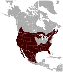
English: Geographical distribution of the Bobcat Lynx rufus, with national borders added. The map was created using the Generic Mapping Tools, GMT, version 5.1.1. |
| Petsa | |
| Ginkuhaan |
Own work using: the IUCN Red List spatial data to draw the borders of the Lynx rufus range: |
| Awtor | Darekk2 using the IUCN Red List spatial data |
| Other versions |
|

Palilisensya:
Attribution: The author of the work and the IUCN Red List spatial data.
You must provide the appropriate credit for the IUCN Red List spatial data:
IUCN (International Union for Conservation of Nature) 2008. Lynx rufus. In: IUCN 2014. The IUCN Red List of Threatened Species. Version 2014.3. http://www.iucnredlist.org. Downloaded on 25 February 2015.
and the IUCN Red List spatial data
- Talwas ka:
- para han pagpasaro – para han pagkopya, pagpakalat ngan pagpadangat han buhat
- para han pagremix – pag-adapt han buhat
- Ha ilarom an masunod nga mga kondisyon:
- attribution – Kinahanglanon mo tagan hin kaangayan nga credit, paghatag hin sumpay ngadto ha lisensya, ngan igbutang an imo ginbag-ohan nga binuhat. Puydi mo ini buhaton ha bisan ano nga resonable nga pamaagi, pero diri nimo pagawson nga an naghatag hin lisensya nag-eendorso ha imo o ha imo paggamit.
- share alike – Kun imo ginsagol-hin-otro, gin-iba, o gin-hingayad han buhat, ikaw in angay gud là magpakalat han imo gin-amot ha ilarom la han [http:creativecommons.org/share-your-work/licensing-considerations/compatible-licenses pareho o naangay nga lisensya] sugad han orihinal.
Kaagi han paypay
Pidlita an adlaw/oras para makit-an an fayl nga naggawas hito nga oras.
| Pitsa/Oras | Thumbnail | Mga dimensyon | Gumaramit | Komento | |
|---|---|---|---|---|---|
| waray pa kasasapawi | 23:53, 26 Mayo 2015 | | 704 × 800 (124 nga KB) | Darekk2 | thicker borders of states |
| 17:30, 20 Marso 2015 |  | 703 × 800 (117 nga KB) | Darekk2 | removed transparency of the background | |
| 16:19, 15 Marso 2015 |  | 703 × 800 (129 nga KB) | Darekk2 | previously an incorrect map was used as the background, the range in Mexico was incomplete | |
| 16:10, 15 Marso 2015 |  | 800 × 771 (139 nga KB) | Darekk2 | uncovered Lake Superior ... | |
| 16:09, 25 Pebrero 2015 |  | 705 × 800 (128 nga KB) | Darekk2 | User created page with UploadWizard |
Mga Sumpay
Waray pakli nga nagamit hinin nga file.
Global file usage
An masunod nga iba nga mga wiki in nagamit hini nga file:
- Paggamit ha en.wikipedia.org
- Paggamit ha fy.wikipedia.org
- Paggamit ha tr.wikipedia.org
- Paggamit ha vi.wikipedia.org