
Paypay:CEM-36-Regno-di-Nivche-2429.jpg

Kadako hin nga pahiuna nga pagawas: 800 × 593 nga mga pixel. Iba nga mga resolusyon: 320 × 237 nga mga pixel | 640 × 474 nga mga pixel | 1,024 × 759 nga mga pixel | 1,280 × 949 nga mga pixel | 1,600 × 1,186 nga mga pixel.
Orihinal nga paypay (1,600 × 1,186 nga pixel, kadako han fayl: 1.07 nga MB, MIME nga tipo: image/jpeg)
Dalikyat nga pulong
| Tigtulidong |
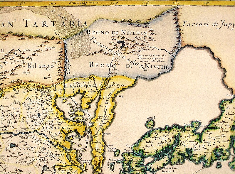
English: Northeastern fragment of a map of China (in Italian), showing the "Tartari del Kin o dell'Oro" (i.e., the Jin Tartars, or the Golden Tartars) populating the "Regno del Niulhan" (?) a.k.a. "Regno del Niuche" (i.e. the Kingdom of the Nüzhen, a.k.a Jurchen") who are further described as "The Tartars who have occupied, and at present are ruling, China". Further northeast, the "Tartari de Yupy" (i.e., "Fishskin Tartars" - the generic name of the Tungusic people of the Amur) are shown.
Italiano: "Il regno della China detto presentemente Catay e Mangin diuiso sopra le carte piu esatte nelle sue principali prouincie" |
| Petsa | Originally published 1682; the copy at HKUST is a 1689 reprint. |
| Ginkuhaan |
English: An antique map from the Special Collection "China in Maps" of the Hong Kong University of Science and Technology Library, reproduced by the HKUST Library in the book "China in European Maps", Hong Kong, 2003. ISBN 962-86403-9-9.
Русский: Старинная карта из специальной коллекции Библиотеки Гонконгского научно-технического университета. Опубликована этой библиотекой в книге "China in European Maps" (Китай на европейских картах), Гонконг, 2003. ISBN 962-86403-9-9, тиражом 1000 экз. См. также каталог выставки, Special Collection "China in Maps".
. Fragment of Plate 36: "Il regno della China detto presentemente Catay e Mangin diuiso sopra le carte piu esatte nelle sue principali prouincie" |
| Awtor | Giacomo Cantelli (1643-1695), Giovanni Giacomo de Rossi (1627-1691) |
| Other versions |
Entire map:  |
Palilisensya:
|
This is a faithful photographic reproduction of a two-dimensional, public domain work of art. The work of art itself is in the public domain for the following reason:
The official position taken by the Wikimedia Foundation is that "faithful reproductions of two-dimensional public domain works of art are public domain".
This photographic reproduction is therefore also considered to be in the public domain in the United States. In other jurisdictions, re-use of this content may be restricted; see Reuse of PD-Art photographs for details. | ||||
Kaagi han paypay
Pidlita an adlaw/oras para makit-an an fayl nga naggawas hito nga oras.
| Pitsa/Oras | Thumbnail | Mga dimensyon | Gumaramit | Komento | |
|---|---|---|---|---|---|
| waray pa kasasapawi | 12:40, 12 Agosto 2013 | | 1,600 × 1,186 (1.07 nga MB) | Soerfm | Crop, brightness |
| 04:06, 18 Marso 2009 |  | 1,600 × 1,200 (1,024 nga KB) | Vmenkov | {{Information |Description={{en|1=Northeastern fragment of a 1682 map of China (in Italian), showing the "Tartari del Kin o dell'Oro" (i.e., the Jin Tartars, or the Golden Tartars) populating the "Regno del Niulhan" (?) a.k.a. "Regno del Niuche" (i.e. the |
Mga Sumpay
An mga nasunod nga mga pakli nasumpay hini nga paypay:
Global file usage
An masunod nga iba nga mga wiki in nagamit hini nga file:
- Paggamit ha bcl.wikipedia.org
- Paggamit ha bg.wikipedia.org
- Paggamit ha en.wikipedia.org
- Paggamit ha es.wikipedia.org
- Paggamit ha fr.wikipedia.org
- Paggamit ha gl.wikipedia.org
- Paggamit ha gu.wikipedia.org
- Paggamit ha hy.wikipedia.org
- Paggamit ha id.wikipedia.org
- Paggamit ha la.wikipedia.org
- Paggamit ha nl.wikipedia.org
- Paggamit ha oc.wikipedia.org
- Paggamit ha pa.wikipedia.org
- Paggamit ha pnb.wikipedia.org
- Paggamit ha pt.wikipedia.org
- Paggamit ha ro.wikipedia.org
- Paggamit ha ru.wikipedia.org
- Paggamit ha uk.wikipedia.org
- Paggamit ha vi.wikipedia.org
- Paggamit ha zh.wikipedia.org