
Paypay:Chios topographic map-fr.svg

Size of this PNG preview of this SVG file: 800 × 582 nga mga pixel. Iba nga mga resolusyon: 320 × 233 nga mga pixel | 640 × 466 nga mga pixel | 1,024 × 745 nga mga pixel | 1,280 × 932 nga mga pixel | 2,560 × 1,863 nga mga pixel | 1,580 × 1,150 nga mga pixel.
Orihinal nga paypay (SVG nga fayl, ginbabanabanahan nga 1,580 × 1,150 nga mga pixel, kadako han fayl: 1.35 nga MB)
Dalikyat nga pulong
| Camera location | | View this and other nearby images on: OpenStreetMap |
|---|
| Tigtulidong |
[]
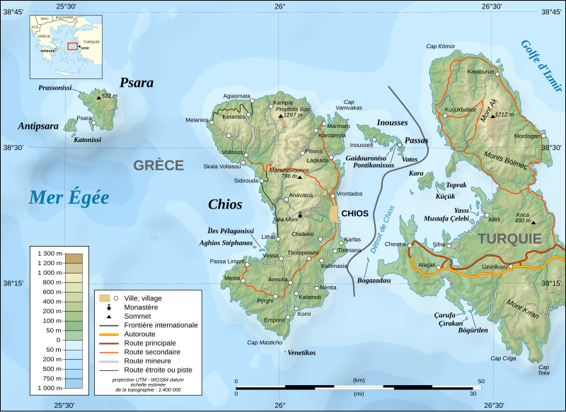
English: Note: The shaded relief is a raster image embedded in the SVG file.
Français : Note : Les ombre du relief sont une image bitmap embarquée dans le fichier SVG.
UTM projection ; WGS84 datum ; shaded relief (composite image of N-W, W and N lightning positions) ;
|
||
| Petsa | November 2007 (modified august 2008) | ||
| Ginkuhaan |
Own work ;
|
||
| Awtor | Eric Gaba (Sting - fr:Sting) | ||
| Pagtugot (Gin-uutro paggamit inin nga file) |
|
||
| Other versions |
[]
|


|
This SVG file contains embedded text that can be translated into your language, using any capable SVG editor, text editor or the SVG Translate tool. For more information see: About translating SVG files. |
Palilisensya:
I, the copyright holder of this work, hereby publish it under the following licenses:

|
An permiso in ginhatag ha pagkopya, pagpakalat ngan/o pagliwat hinin nga dokumento ha ilarom han mga termino han GNU Free Documentation License, Version 1.2 o mas uruurhi nga version nga ginmantala han Free Software Foundation; nga may-ada waray Invariant Sections, waray Front-Cover Texts, ngan waray Back-Cover Texts. May-ada kopya hin lisensya nga ginlalakip ha seksyon nga may-ada pamagat nga GNU Free Documentation License. |
This file is licensed under the Creative Commons Attribution-Share Alike 4.0 International, 3.0 Unported, 2.5 Generic, 2.0 Generic and 1.0 Generic license.
- Talwas ka:
- para han pagpasaro – para han pagkopya, pagpakalat ngan pagpadangat han buhat
- para han pagremix – pag-adapt han buhat
- Ha ilarom an masunod nga mga kondisyon:
- attribution – Kinahanglanon mo tagan hin kaangayan nga credit, paghatag hin sumpay ngadto ha lisensya, ngan igbutang an imo ginbag-ohan nga binuhat. Puydi mo ini buhaton ha bisan ano nga resonable nga pamaagi, pero diri nimo pagawson nga an naghatag hin lisensya nag-eendorso ha imo o ha imo paggamit.
- share alike – Kun imo ginsagol-hin-otro, gin-iba, o gin-hingayad han buhat, ikaw in angay gud là magpakalat han imo gin-amot ha ilarom la han [http:creativecommons.org/share-your-work/licensing-considerations/compatible-licenses pareho o naangay nga lisensya] sugad han orihinal.
Puydi ka pumili hin lisenysa nga karuyag mo.
Kaagi han paypay
Pidlita an adlaw/oras para makit-an an fayl nga naggawas hito nga oras.
| Pitsa/Oras | Thumbnail | Mga dimensyon | Gumaramit | Komento | |
|---|---|---|---|---|---|
| waray pa kasasapawi | 17:26, 27 Enero 2022 | | 1,580 × 1,150 (1.35 nga MB) | Pinacotecus | Reverted to version as of 04:38, 1 September 2008 (UTC) |
| 16:39, 27 Enero 2022 |  | 1,580 × 1,150 (1.4 nga MB) | Pinacotecus | File uploaded using svgtranslate tool (https://svgtranslate.toolforge.org/). Added translation for en. | |
| 16:23, 27 Enero 2022 |  | 1,580 × 1,150 (1.4 nga MB) | Pinacotecus | File uploaded using svgtranslate tool (https://svgtranslate.toolforge.org/). Added translation for en. | |
| 04:38, 1 Septyembre 2008 |  | 1,580 × 1,150 (1.35 nga MB) | Sting | New bathymetry from NGDC ETOPO1 ; new standard colors | |
| 23:44, 28 Nobyembre 2007 |  | 1,580 × 1,150 (1.18 nga MB) | Sting | {{Information |Description=Topographic map in French of Chios and Psara islands, Aegean Sea, Greece |Source=Own work ;<br/>Topography : [http://www2.jpl.nasa.gov/srtm NASA Shuttle Radar Top |
Mga Sumpay
An mga nasunod nga mga pakli nasumpay hini nga paypay:
Global file usage
An masunod nga iba nga mga wiki in nagamit hini nga file:
- Paggamit ha el.wikipedia.org
- Paggamit ha fr.wikipedia.org
- Paggamit ha fr.wiktionary.org
- Paggamit ha hu.wikipedia.org
- Paggamit ha ia.wikipedia.org
- Paggamit ha it.wikipedia.org
- Paggamit ha ku.wikipedia.org
- Paggamit ha no.wikipedia.org
- Paggamit ha pt.wikipedia.org
- Paggamit ha ru.wikipedia.org
- Paggamit ha sr.wikipedia.org
- Paggamit ha tr.wikipedia.org
- Paggamit ha uk.wikipedia.org