
Paypay:East Timor municipalities names 2003-2015.png

Kadako hin nga pahiuna nga pagawas: 800 × 354 nga mga pixel. Iba nga mga resolusyon: 320 × 141 nga mga pixel | 640 × 283 nga mga pixel | 1,024 × 453 nga mga pixel | 2,000 × 884 nga mga pixel.
Orihinal nga paypay (2,000 × 884 nga pixel, kadako han fayl: 184 nga KB, MIME nga tipo: image/png)

|
This file has been superseded by Municipalities of Timor-Leste.png. It is recommended to use the other file. Please note that deleting superseded images requires consent.
|

|
| Tigtulidong |
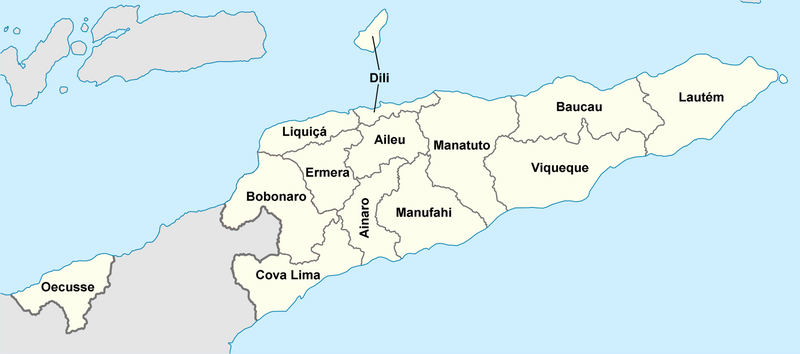
Deutsch: Lagekarte der Gemeinden Osttimors English: Locator map of municipalities of East Timor |
| Petsa | (UTC) |
| Ginkuhaan | |
| Awtor |
|
| This is a retouched picture, which means that it has been digitally altered from its original version. Modifications: Districts named. The original can be viewed here: East Timor Aileu locator map.svg:
|
I, the copyright holder of this work, hereby publish it under the following licenses:
This file is licensed under the Creative Commons Attribution 3.0 Unported license.
- Talwas ka:
- para han pagpasaro – para han pagkopya, pagpakalat ngan pagpadangat han buhat
- para han pagremix – pag-adapt han buhat
- Ha ilarom an masunod nga mga kondisyon:
- attribution – Kinahanglanon mo tagan hin kaangayan nga credit, paghatag hin sumpay ngadto ha lisensya, ngan igbutang an imo ginbag-ohan nga binuhat. Puydi mo ini buhaton ha bisan ano nga resonable nga pamaagi, pero diri nimo pagawson nga an naghatag hin lisensya nag-eendorso ha imo o ha imo paggamit.

|
An permiso in ginhatag ha pagkopya, pagpakalat ngan/o pagliwat hinin nga dokumento ha ilarom han mga termino han GNU Free Documentation License, Version 1.2 o mas uruurhi nga version nga ginmantala han Free Software Foundation; nga may-ada waray Invariant Sections, waray Front-Cover Texts, ngan waray Back-Cover Texts. May-ada kopya hin lisensya nga ginlalakip ha seksyon nga may-ada pamagat nga GNU Free Documentation License. |
Puydi ka pumili hin lisenysa nga karuyag mo.
Original upload log
This image is a derivative work of the following images:
- File:East_Timor_Aileu_locator_map.svg licensed with Cc-by-3.0, GFDL
- 2009-05-27T21:09:12Z NordNordWest 1607x710 (127180 Bytes) {{Information |Description= {{de|Lagekarte des Distrikts Aileu, Osttimor}} {{en|Locator map of Aileu district, East Timor}} |Source=self-made, using * [[:file:East Timor location map.svg|East Timor location map.svg]] |Date=2
Uploaded with derivativeFX
Kaagi han paypay
Pidlita an adlaw/oras para makit-an an fayl nga naggawas hito nga oras.
| Pitsa/Oras | Thumbnail | Mga dimensyon | Gumaramit | Komento | |
|---|---|---|---|---|---|
| waray pa kasasapawi | 06:38, 1 Hulyo 2010 | | 2,000 × 884 (184 nga KB) | J. Patrick Fischer | {{Information |Description={{de|Lagekarte des Distrikte Osttimors}} {{en|Locator map of districts of East Timor}} |Source=*File:East_Timor_Aileu_locator_map.svg |Date=2010-07-01 06:35 (UTC) |Author=*File:East_Timor_Aileu_locator_map.svg: [[Us |
Mga Sumpay
Waray pakli nga nagamit hinin nga file.
Global file usage
An masunod nga iba nga mga wiki in nagamit hini nga file:
- Paggamit ha de.wikipedia.org
- Paggamit ha incubator.wikimedia.org