
Paypay:East and southern africa early iron age.png
Kadako hin nga pahiuna nga pagawas: 518 × 600 nga mga pixel. Iba nga mga resolusyon: 207 × 240 nga mga pixel | 414 × 480 nga mga pixel | 677 × 784 nga mga pixel.
Orihinal nga paypay (677 × 784 nga pixel, kadako han fayl: 15 nga KB, MIME nga tipo: image/png)
| Tigtulidong |
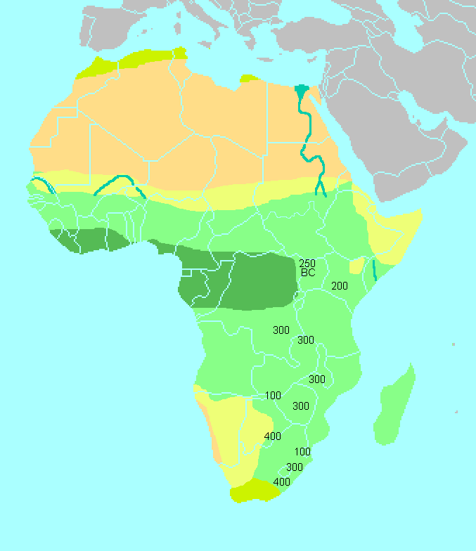
Spread of the "Early Iron Age" in Eastern, Central and Southern Africa, a proxy for the Bantu migrations. Based on K. Shillington, History of Africa (3rd ed. 2005), p. 63. Urewe (Lake Victoria) 250 BCE, Kwale 200 CE, Kisale 300 CE, , Kalundu/Dambwa 100 CE , Kalambo 300 CE, Nkope 300 CE, Gokmere-Ziwa/Bambata 300 CE, presence in South Africa (Kei river) by 400 CE. |
| Petsa |
(UTC)
|
| Ginkuhaan | |
| Awtor |
I, the copyright holder of this work, hereby publish it under the following license:
| I, the copyright holder of this work, release this work into the public domain. This applies worldwide. In some countries this may not be legally possible; if so: I grant anyone the right to use this work for any purpose, without any conditions, unless such conditions are required by law. |
Original upload log
This image is a png version of the following image:
- Image:East&southern africa early iron age.gif licensed with PD-self
- 2007-04-27T13:07:06Z Ulamm 677x784 (16174 Bytes) {{Information |Description=Early iron age findings in eastern and southern Africa, dates obtained form "History of Africa" (Kevin Shillington 2005) |Source=own painting in a PD map (wiki: States of Africa) |Date=2007-04-27 |A
Uploaded with derivativeFX
Kaagi han paypay
Pidlita an adlaw/oras para makit-an an fayl nga naggawas hito nga oras.
| Pitsa/Oras | Thumbnail | Mga dimensyon | Gumaramit | Komento | |
|---|---|---|---|---|---|
| waray pa kasasapawi | 20:02, 29 Agosto 2011 | | 677 × 784 (15 nga KB) | Derfel73 | Added South Sudan |
| 07:05, 31 Marso 2011 |  | 677 × 784 (29 nga KB) | Hoshie | added Cabinda (Angola) and Montenegro to the map. | |
| 13:44, 10 Disyembre 2008 |  | 677 × 784 (16 nga KB) | JalalV | {{Information |Description=Early iron age findings in eastern and southern Africa, dates obtained form "History of Africa" (Kevin Shillington 2005) |Source=*Image:East&southern_africa_early_iron_age.gif |Date=2008-12-10 13:41 (UTC) *[[:Image:East% |
Mga Sumpay
An mga nasunod nga mga pakli nasumpay hini nga paypay:
Global file usage
An masunod nga iba nga mga wiki in nagamit hini nga file:
- Paggamit ha als.wikipedia.org
- Paggamit ha ar.wikipedia.org
- Paggamit ha ast.wikipedia.org
- Paggamit ha cs.wikipedia.org
- Paggamit ha en.wikipedia.org
- Paggamit ha es.wikipedia.org
- Paggamit ha fr.wikipedia.org
- Paggamit ha ha.wikipedia.org
- Paggamit ha ja.wikipedia.org
- Paggamit ha pa.wikipedia.org
- Paggamit ha pl.wikipedia.org
- Paggamit ha pnb.wikipedia.org
- Paggamit ha pt.wikipedia.org
- Paggamit ha rw.wikipedia.org
- Paggamit ha sat.wikipedia.org
- Paggamit ha sv.wikibooks.org
- Paggamit ha sw.wikipedia.org
- Paggamit ha ta.wikipedia.org
- Paggamit ha zh.wikipedia.org