
Paypay:Easter Island map-en.svg

Size of this PNG preview of this SVG file: 800 × 569 nga mga pixel. Iba nga mga resolusyon: 320 × 228 nga mga pixel | 640 × 455 nga mga pixel | 1,024 × 729 nga mga pixel | 1,280 × 911 nga mga pixel | 2,560 × 1,821 nga mga pixel | 1,750 × 1,245 nga mga pixel.
Orihinal nga paypay (SVG nga fayl, ginbabanabanahan nga 1,750 × 1,245 nga mga pixel, kadako han fayl: 878 nga KB)
Dalikyat nga pulong
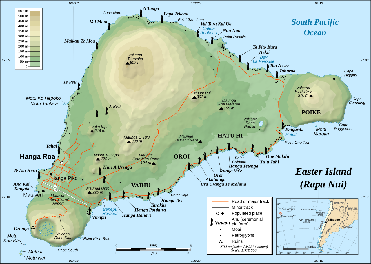
This image was selected as picture of the day on Wikimedia Commons for 1 December 2008. It was captioned as follows: English: Detailed topographic map in English of Easter Island. Other languages:
Afrikaans: Gedetaileerde topografie van Paaseiland Català: Mapa topogràfic detallat en anglès de l'Illa de Pasqua. Čeština: Detailní topografická mapa Velikonočního ostrova Eesti: Detailne inglisekeelne topograafiline kaart et:Lihavõttesaarest. English: Detailed topographic map in English of Easter Island. Esperanto: detala topografia mapo de la Paskinsulo (jen anglalingva, sed ankaŭ havebla en pluraj aliaj lingvoj) Français : Carte topographique détaillée en anglais de l'île de Pâques Italiano: Mappa topografica dell'Isola di Pasqua, Cile. Nederlands: Engelstalige gedetailleerde topografische kaart van Paaseiland Português: Mapa topográfico detalhado, em Inglês, da Ilha da Páscoa Română: Hartă topografică detaliată, în limba engleză, a insulei Paștelui. Svenska: Detaljerad topografisk karta på engelska över Påskön. Македонски: Детална топографска карта на Велигденскиот Остров на англиски. Русский: Топографическая карта Острова Пасхи 한국어: 이스터 섬의 지형도. 中文: 复活节岛地形图 中文(繁體): 復活節島地形圖 |
|

| Tigtulidong |
English: Detailed topographic map in English of Easter Island
Français : Carte topographique détaillée en anglais de l'île de Paques
Português: Mapa topográfico detalhado, em Inglês, da Ilha da Páscoa.
|
| Petsa | October 2007 - October 2008 for the new version (see the release note) |
| Ginkuhaan |
Own work
|
| Awtor | Eric Gaba (Sting), translated by Bamse |
| Pagtugot (Gin-uutro paggamit inin nga file) |
Creative Commons: Share Alike – attribution required |
| Other versions |
[]
|


![[1]](http://www.waymarker.co.uk/ml/rapanui/map.jpg)
This W3C-unspecified vector image was created with Inkscape .

|
This SVG file contains embedded text that can be translated into your language, using any capable SVG editor, text editor or the SVG Translate tool. For more information see: About translating SVG files. |
Palilisensya:
I, the copyright holder of this work, hereby publish it under the following license:
This file is licensed under the Creative Commons Attribution-Share Alike 2.5 Generic license.
- Talwas ka:
- para han pagpasaro – para han pagkopya, pagpakalat ngan pagpadangat han buhat
- para han pagremix – pag-adapt han buhat
- Ha ilarom an masunod nga mga kondisyon:
- attribution – Kinahanglanon mo tagan hin kaangayan nga credit, paghatag hin sumpay ngadto ha lisensya, ngan igbutang an imo ginbag-ohan nga binuhat. Puydi mo ini buhaton ha bisan ano nga resonable nga pamaagi, pero diri nimo pagawson nga an naghatag hin lisensya nag-eendorso ha imo o ha imo paggamit.
- share alike – Kun imo ginsagol-hin-otro, gin-iba, o gin-hingayad han buhat, ikaw in angay gud là magpakalat han imo gin-amot ha ilarom la han [http:creativecommons.org/share-your-work/licensing-considerations/compatible-licenses pareho o naangay nga lisensya] sugad han orihinal.
Kaagi han paypay
Pidlita an adlaw/oras para makit-an an fayl nga naggawas hito nga oras.
| Pitsa/Oras | Thumbnail | Mga dimensyon | Gumaramit | Komento | |
|---|---|---|---|---|---|
| waray pa kasasapawi | 22:51, 11 Enero 2023 | | 1,750 × 1,245 (878 nga KB) | Tseng,Lu-Yen | Reverted to version as of 12:43, 22 October 2008 (UTC) |
| 07:17, 10 Disyembre 2011 |  | 1,750 × 1,245 (1.92 nga MB) | Hel-hama | Text appearance improved using Inkscape. | |
| 12:43, 22 Oktubre 2008 |  | 1,750 × 1,245 (878 nga KB) | Sting | Completely new version of the map ; new standard colors | |
| 01:06, 30 Oktubre 2007 |  | 1,750 × 1,245 (536 nga KB) | Sting | Some additional info | |
| 00:37, 19 Oktubre 2007 |  | 1,750 × 1,245 (534 nga KB) | Bamse | ||
| 00:14, 19 Oktubre 2007 |  | 1,750 × 1,245 (534 nga KB) | Bamse | {{Information |Description= |Source=self-made |Date= |Author= Bamse }} == Summary == {{Information| |Description=Detailed topographic map in English of Easter island |Source=Own work, translation of Image:Easter Island map-fr.svg<b |
Mga Sumpay
An mga nasunod nga mga pakli nasumpay hini nga paypay:
Global file usage
An masunod nga iba nga mga wiki in nagamit hini nga file:
- Paggamit ha af.wikipedia.org
- Paggamit ha ami.wikipedia.org
- Paggamit ha ar.wikipedia.org
- Paggamit ha az.wikipedia.org
- Paggamit ha bcl.wikipedia.org
- Paggamit ha bn.wikipedia.org
- Paggamit ha ca.wikipedia.org
- Paggamit ha ckb.wikipedia.org
- Paggamit ha da.wikipedia.org
- Paggamit ha de.wikipedia.org
- Paggamit ha el.wikipedia.org
- Paggamit ha en.wikipedia.org
- Cartography
- Easter Island
- Hanga Roa
- Mu (mythical lost continent)
- Moai
- Motu Nui
- Map coloring
- Rapa Nui National Park
- Hanau epe
- Orongo
- Ahu Tongariki
- Poike
- Rano Kau
- Terevaka
- Ahu Akivi
- List of active separatist movements in Oceania
- User:ISaveNewspapers/sandbox
- Isla de Pascua (commune)
- Portal:Geodesy
- User:Iamojo/testcase/EasterIsland
- Paggamit ha en.wikiversity.org
- Paggamit ha en.wikivoyage.org
- Paggamit ha es.wikipedia.org
- Paggamit ha et.wikipedia.org
- Paggamit ha fa.wikipedia.org
- Paggamit ha frr.wikipedia.org
- Paggamit ha fr.wikipedia.org
- Paggamit ha gl.wikipedia.org
Kitaa durudamo nga global usage hinin nga file.