
Paypay:Fire-island-map.jpg
Kadako hin nga pahiuna nga pagawas: 800 × 317 nga mga pixel. Iba nga mga resolusyon: 320 × 127 nga mga pixel | 640 × 253 nga mga pixel | 1,024 × 405 nga mga pixel | 1,280 × 506 nga mga pixel | 3,493 × 1,382 nga mga pixel.
Orihinal nga paypay (3,493 × 1,382 nga pixel, kadako han fayl: 363 nga KB, MIME nga tipo: image/jpeg)
Dalikyat nga pulong
| Description |
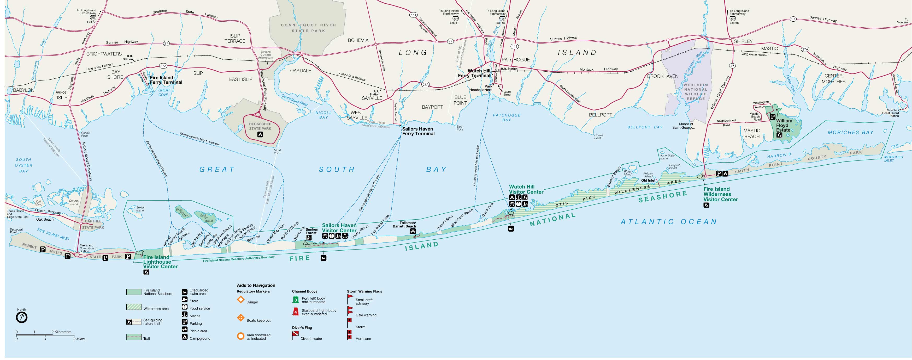
English: Fire Island map from USGS |
||
| Ginkuhaan | http://ny.cf.er.usgs.gov/nyprojectsearch/projects/2457-BUF-1.html | ||
| Creator |
United States Geological Survey / Fire Island Inlet National Park |
||
| Georeferencing | If inappropriate please set warp_status = skip to hide. | ||
| Other versions |
|


Palilisensya:
This image is in the public domain in the United States because it only contains materials that originally came from the United States Geological Survey, an agency of the United States Department of the Interior. For more information, see the official USGS copyright policy.
|
Original upload log
Transferred from en.wikipedia to Commons by Vmenkov using CommonsHelper.
The original description page was here. All following user names refer to en.wikipedia.
- 2007-11-21 10:21 Americasroof 3493×1382× (371827 bytes) [[Fire Island, New York]] map from USGS http://ny.cf.er.usgs.gov/nyprojectsearch/projects/projectImages/2457-BUF-1_image002.jpg
Kaagi han paypay
Pidlita an adlaw/oras para makit-an an fayl nga naggawas hito nga oras.
| Pitsa/Oras | Thumbnail | Mga dimensyon | Gumaramit | Komento | |
|---|---|---|---|---|---|
| waray pa kasasapawi | 00:50, 11 Hunyo 2011 | 3,493 × 1,382 (363 nga KB) | File Upload Bot (Magnus Manske) | {{BotMoveToCommons|en.wikipedia|year={{subst:CURRENTYEAR}}|month={{subst:CURRENTMONTHNAME}}|day={{subst:CURRENTDAY}}}} {{Information |Description={{en|en:Fire Island, New York map from USGS}} |Source=Transferred from [http://en.wikipedia.org en.wik |
Mga Sumpay
An mga nasunod nga mga pakli nasumpay hini nga paypay:
Global file usage
An masunod nga iba nga mga wiki in nagamit hini nga file:
- Paggamit ha ar.wikipedia.org
- Paggamit ha ceb.wikipedia.org
- Paggamit ha de.wikipedia.org
- Paggamit ha en.wikipedia.org
- Saltaire, New York
- Fire Island
- Fire Island National Seashore
- Fire Island Pines, New York
- Fair Harbor, New York
- Lonelyville, New York
- Patchogue Bay
- Watch Hill (New York)
- List of municipalities on Long Island
- Moriches Bay
- Module:Location map/data/USA New York Fire Island/doc
- Module:Location map/data/USA New York Fire Island
- Paggamit ha fa.wikipedia.org
- Paggamit ha fr.wikipedia.org
- Paggamit ha it.wikipedia.org
- Paggamit ha pl.wikipedia.org
- Paggamit ha si.wikipedia.org
- Paggamit ha www.wikidata.org
- Paggamit ha zh.wikipedia.org