
Paypay:Flores Locator Topography.png

Kadako hin nga pahiuna nga pagawas: 800 × 473 nga mga pixel. Iba nga mga resolusyon: 320 × 189 nga mga pixel | 640 × 379 nga mga pixel | 1,024 × 606 nga mga pixel | 1,280 × 757 nga mga pixel | 2,559 × 1,514 nga mga pixel.
Orihinal nga paypay (2,559 × 1,514 nga pixel, kadako han fayl: 1.46 nga MB, MIME nga tipo: image/png)
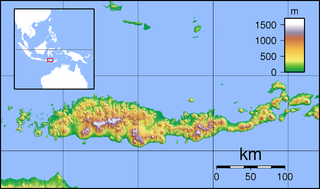
| Tigtulidong | Topographic map of Flores, Indonesia. Created with GMT from SRTM data. |
| Petsa | (UTC) |
| Ginkuhaan | |
| Awtor |
|
| This is a retouched picture, which means that it has been digitally altered from its original version. Modifications: croped margins. The original can be viewed here: Flores Topography.png:
|
I, the copyright holder of this work, hereby publish it under the following licenses:
This file is licensed under the Creative Commons Attribution-Share Alike 3.0 Unported, 2.5 Generic, 2.0 Generic and 1.0 Generic license.
- Talwas ka:
- para han pagpasaro – para han pagkopya, pagpakalat ngan pagpadangat han buhat
- para han pagremix – pag-adapt han buhat
- Ha ilarom an masunod nga mga kondisyon:
- attribution – Kinahanglanon mo tagan hin kaangayan nga credit, paghatag hin sumpay ngadto ha lisensya, ngan igbutang an imo ginbag-ohan nga binuhat. Puydi mo ini buhaton ha bisan ano nga resonable nga pamaagi, pero diri nimo pagawson nga an naghatag hin lisensya nag-eendorso ha imo o ha imo paggamit.
- share alike – Kun imo ginsagol-hin-otro, gin-iba, o gin-hingayad han buhat, ikaw in angay gud là magpakalat han imo gin-amot ha ilarom la han [http:creativecommons.org/share-your-work/licensing-considerations/compatible-licenses pareho o naangay nga lisensya] sugad han orihinal.

|
An permiso in ginhatag ha pagkopya, pagpakalat ngan/o pagliwat hinin nga dokumento ha ilarom han mga termino han GNU Free Documentation License, Version 1.2 o mas uruurhi nga version nga ginmantala han Free Software Foundation; nga may-ada waray Invariant Sections, waray Front-Cover Texts, ngan waray Back-Cover Texts. May-ada kopya hin lisensya nga ginlalakip ha seksyon nga may-ada pamagat nga GNU Free Documentation License. |
Puydi ka pumili hin lisenysa nga karuyag mo.
Original upload log
This image is a derivative work of the following images:
- File:Flores_Topography.png licensed with Cc-by-sa-3.0,2.5,2.0,1.0, GFDL
- 2007-09-11T21:28:50Z Sadalmelik 2745x1665 (1468315 Bytes) {{Information |Description=Topographic map of Flores, Indonesia. Created with GMT from SRTM data. |Source=self-made |Date=Sep 11, 2007 |Author= [[User:Sadalmelik|Sadalmelik]] }} [[Category:Maps of Indonesia]] [[Category:Topo
Uploaded with derivativeFX
Kaagi han paypay
Pidlita an adlaw/oras para makit-an an fayl nga naggawas hito nga oras.
| Pitsa/Oras | Thumbnail | Mga dimensyon | Gumaramit | Komento | |
|---|---|---|---|---|---|
| waray pa kasasapawi | 04:20, 1 Pebrero 2010 | | 2,559 × 1,514 (1.46 nga MB) | Elekhh | {{Information |Description=Topographic map of Flores, Indonesia. Created with GMT from SRTM data. |Source=*File:Flores_Topography.png |Date=2010-02-01 04:17 (UTC) |Author=*File:Flores_Topography.png: Sadalmelik *derivative |
Mga Sumpay
An mga nasunod nga mga pakli nasumpay hini nga paypay:
Global file usage
An masunod nga iba nga mga wiki in nagamit hini nga file:
- Paggamit ha ar.wikipedia.org
- Paggamit ha arz.wikipedia.org
- Paggamit ha ban.wikipedia.org
- Paggamit ha ceb.wikipedia.org
- Paggamit ha en.wikipedia.org
- Komodo National Park
- Iliboleng
- Paluweh
- Kelimutu
- Palu'e language
- List of national parks of Indonesia
- Sikka Regency
- Ende Regency
- Ende (town)
- Maumere
- Poco Mandasawu
- Ranakah
- Lewotobi
- Leroboleng
- Mount Egon
- Ebulobo
- Inierie
- Mount Iya
- Inielika
- Wai Sano
- Sumba Strait
- Kelimutu National Park
- Larantuka
- H. Hasan Aroeboesman Airport
- Komodo International Airport
- Frans Xavier Seda Airport
- 1992 Flores earthquake and tsunami
- Ruteng
- Ngada Regency
- West Manggarai Regency
- East Flores Regency
- Manggarai Regency
- Nagekeo Regency
- East Manggarai Regency
- Labuan Bajo
- Module:Location map/data/Indonesia Flores/doc
Kitaa durudamo nga global usage hinin nga file.