
Paypay:Fukuoka Viewed From Minamiku Observation Deck.jpg
Kadako hin nga pahiuna nga pagawas: 800 × 339 nga mga pixel. Iba nga mga resolusyon: 320 × 135 nga mga pixel | 640 × 271 nga mga pixel | 1,536 × 650 nga mga pixel.
Orihinal nga paypay (1,536 × 650 nga pixel, kadako han fayl: 189 nga KB, MIME nga tipo: image/jpeg)
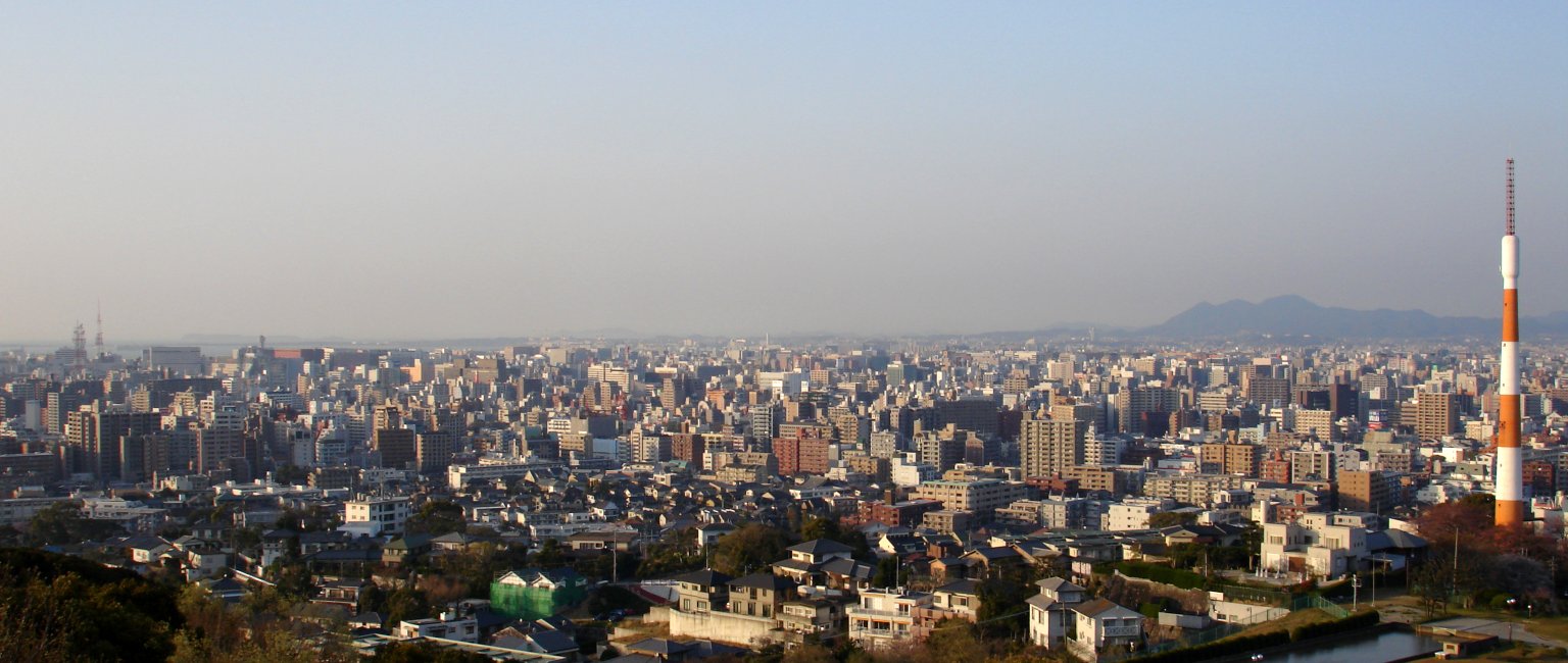
A view of downtown Fukuoka taken from Minami-ku's observation tower near Takamiya Station. Tenjin, Chuo-ku is a the left-hand side of the picture, Hakata is in the middle, and Takamiya appears at the right. The mountains appearing in the distance are, from left to right, Tachibana-san, Mikkazuki-san and Sanbonmatsu-san. At the foot of the three mountains is Kashii, Higashi-ku.

|
An permiso in ginhatag ha pagkopya, pagpakalat ngan/o pagliwat hinin nga dokumento ha ilarom han mga termino han GNU Free Documentation License, Version 1.2 o mas uruurhi nga version nga ginmantala han Free Software Foundation; nga may-ada waray Invariant Sections, waray Front-Cover Texts, ngan waray Back-Cover Texts. May-ada kopya hin lisensya nga ginlalakip ha seksyon nga may-ada pamagat nga GNU Free Documentation License. |
| Ini nga file in nakalisensya ha ilarom han Creative Commons Attribution-Share Alike 3.0 Unported license. | ||
| ||
| This licensing tag was added to this file as part of the GFDL licensing update. |
| Camera location | | View this and other nearby images on: OpenStreetMap |
|---|
Kaagi han paypay
Pidlita an adlaw/oras para makit-an an fayl nga naggawas hito nga oras.
| Pitsa/Oras | Thumbnail | Mga dimensyon | Gumaramit | Komento | |
|---|---|---|---|---|---|
| waray pa kasasapawi | 15:34, 5 Abril 2005 | | 1,536 × 650 (189 nga KB) | Oarih~commonswiki | A view of downtown Fukuoka taken from Minami-ku's observation tower near Takamiya Station. Tenjin, Chuo-ku is a the left-hand side of the picture, Hakata is in the middle, and Takamiya appears at the right. The mountains appearing in the distance are, f |
Mga Sumpay
An mga nasunod nga mga pakli nasumpay hini nga paypay:
Global file usage
An masunod nga iba nga mga wiki in nagamit hini nga file:
- Paggamit ha ar.wikipedia.org
- Paggamit ha bg.wikipedia.org
- Paggamit ha ce.wikipedia.org
- Paggamit ha cs.wikipedia.org
- Paggamit ha da.wikipedia.org
- Paggamit ha eo.wikipedia.org
- Paggamit ha et.wikipedia.org
- Paggamit ha fi.wikipedia.org
- Paggamit ha hi.wikipedia.org
- Paggamit ha hr.wikipedia.org
- Paggamit ha hy.wikipedia.org
- Paggamit ha id.wikipedia.org
- Paggamit ha it.wikipedia.org
- Paggamit ha ja.wikipedia.org
- Paggamit ha jv.wikipedia.org
- Paggamit ha ka.wikipedia.org
- Paggamit ha lt.wikipedia.org
- Paggamit ha mn.wikipedia.org
- Paggamit ha nl.wikipedia.org
- Paggamit ha pl.wikipedia.org
- Paggamit ha pnb.wikipedia.org
- Paggamit ha ru.wikipedia.org
- Paggamit ha su.wikipedia.org
- Paggamit ha sv.wikipedia.org
- Paggamit ha tl.wikipedia.org
- Paggamit ha tt.wikipedia.org
- Paggamit ha ur.wikipedia.org
- Paggamit ha www.wikidata.org
- Paggamit ha zh.wikipedia.org