
Paypay:GB-Definition-Map.jpg
Waray mas hiruhitaas nga resolusyon.
GB-Definition-Map.jpg (286 × 392 nga pixel, kadako han fayl: 17 nga KB, MIME nga tipo: image/jpeg)

|
This geology image could be re-created using vector graphics as an SVG file. This has several advantages; see Commons:Media for cleanup for more information. If an SVG form of this image is available, please upload it and afterwards replace this template with
{{vector version available|new image name}}.
It is recommended to name the SVG file “GB-Definition-Map.svg”—then the template Vector version available (or Vva) does not need the new image name parameter. |


Dalikyat nga pulong
| Tigtulidong |
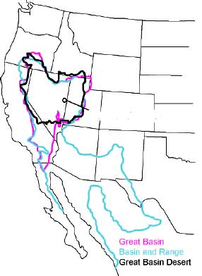
English: The Great Basin can be defined hydrographically (in purple), topographically (in blue), or biologically (in black). |
|||
| Petsa | 30 Agosto 2006 (original upload date) | |||
| Ginkuhaan | http://www.nps.gov/grba/planyourvisit/the-great-basin.htm | |||
| Awtor | U.S. National Park Service | |||
| Pagtugot (Gin-uutro paggamit inin nga file) |
|
|||
| Other versions | cleaned-up gif version |
Original upload log
Transferred from en.wikipedia to Commons by Psemper.
- 2006-08-30 05:11 Bplewe 286×392×8 (17013 bytes) source: Great Basin National Park, http://www.nps.gov/grba/planyourvisit/the-great-basin.htm
Kaagi han paypay
Pidlita an adlaw/oras para makit-an an fayl nga naggawas hito nga oras.
| Pitsa/Oras | Thumbnail | Mga dimensyon | Gumaramit | Komento | |
|---|---|---|---|---|---|
| waray pa kasasapawi | 05:24, 13 Hulyo 2015 | | 286 × 392 (17 nga KB) | Hike395 | revert original research |
| 14:19, 4 Enero 2011 |  | 652 × 1,014 (138 nga KB) | Hike796 | +Great Basin tribes area | |
| 14:23, 2 Enero 2008 |  | 286 × 392 (17 nga KB) | Psemper | {{Information |Description= |Source=http://en.wikipedia.org/wiki/Image:GB-Definition-Map.jpg |Date= |Author= |Permission= |other_versions= }} |
Mga Sumpay
Waray pakli nga nagamit hinin nga file.