
Paypay:Golan Heights relief v2.png

Kadako hin nga pahiuna nga pagawas: 522 × 600 nga mga pixel. Iba nga mga resolusyon: 209 × 240 nga mga pixel | 418 × 480 nga mga pixel | 758 × 871 nga mga pixel.
Orihinal nga paypay (758 × 871 nga pixel, kadako han fayl: 923 nga KB, MIME nga tipo: image/png)
Dalikyat nga pulong
| Tigtulidong |
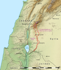
English: This is a shaded relief map illustrating the topography of the Golan Heights and surrounding areas. Transverse Mercator projection (EPSG: 2039) Source data: * Elevation data: SRTM data from NASA[1] * Borders, cities, and geographic features: The Natural Earth
العربية: هذه خريطة مجسمة مظللة توضح تضاريس هضبة الجولان والمناطق المحيطة بها ومآل مناطق النزاع على الحدود بين سوريا وإسرائيل. الإحداثيات حسب نظام إسقاط ميركاتور المستعرض (EPSG: 2039)
مصدر البيانات:
|
| Petsa | (UTC) |
| Ginkuhaan | |
| Awtor |
|
| Other versions | File:Golan Heights geography.png |

|
This map image could be re-created using vector graphics as an SVG file. This has several advantages; see Commons:Media for cleanup for more information. If an SVG form of this image is available, please upload it and afterwards replace this template with
{{vector version available|new image name}}.
It is recommended to name the SVG file “Golan Heights relief v2.svg”—then the template Vector version available (or Vva) does not need the new image name parameter. |
| This is a retouched picture, which means that it has been digitally altered from its original version. Modifications: Adjusted borders to prioritise internationally recognised borders.. The original can be viewed here: Golan Heights relief v1.jpg:
|
Palilisensya:
I, the copyright holder of this work, hereby publish it under the following licenses:
Ini nga file in nakalisensya ha ilarom han Creative Commons Attribution-Share Alike 3.0 Unported license.
- Talwas ka:
- para han pagpasaro – para han pagkopya, pagpakalat ngan pagpadangat han buhat
- para han pagremix – pag-adapt han buhat
- Ha ilarom an masunod nga mga kondisyon:
- attribution – Kinahanglanon mo tagan hin kaangayan nga credit, paghatag hin sumpay ngadto ha lisensya, ngan igbutang an imo ginbag-ohan nga binuhat. Puydi mo ini buhaton ha bisan ano nga resonable nga pamaagi, pero diri nimo pagawson nga an naghatag hin lisensya nag-eendorso ha imo o ha imo paggamit.
- share alike – Kun imo ginsagol-hin-otro, gin-iba, o gin-hingayad han buhat, ikaw in angay gud là magpakalat han imo gin-amot ha ilarom la han [http:creativecommons.org/share-your-work/licensing-considerations/compatible-licenses pareho o naangay nga lisensya] sugad han orihinal.

|
An permiso in ginhatag ha pagkopya, pagpakalat ngan/o pagliwat hinin nga dokumento ha ilarom han mga termino han GNU Free Documentation License, Version 1.2 o mas uruurhi nga version nga ginmantala han Free Software Foundation; nga may-ada waray Invariant Sections, waray Front-Cover Texts, ngan waray Back-Cover Texts. May-ada kopya hin lisensya nga ginlalakip ha seksyon nga may-ada pamagat nga GNU Free Documentation License. |
Puydi ka pumili hin lisenysa nga karuyag mo.
Original upload log
This image is a derivative work of the following images:
- File:Golan_Heights_relief_v1.jpg licensed with Cc-by-sa-3.0, GFDL
- 2011-03-15T03:27:39Z Kbh3rd 758x871 (279344 Bytes) With "Golan Heights" labeled, from original layers to avoid quality issues with Chesdovi's edit
- 2011-03-09T15:33:27Z Chesdovi 615x605 (161970 Bytes) Adding GOLAN HEIGHTS wording
- 2011-01-24T03:44:15Z Kbh3rd 758x871 (278034 Bytes) {{Information |Description ={{en|1=This is a [[:en:shaded relief|shaded relief]] map illustrating the topography of the [[:en:Golan Heights|Golan Heights]] and surrounding areas. Transverse Mercator projection (EPSG: 2039
Uploaded with derivativeFX
Kaagi han paypay
Pidlita an adlaw/oras para makit-an an fayl nga naggawas hito nga oras.
| Pitsa/Oras | Thumbnail | Mga dimensyon | Gumaramit | Komento | |
|---|---|---|---|---|---|
| waray pa kasasapawi | 06:27, 29 Nobyembre 2011 | | 758 × 871 (923 nga KB) | Night w | == {{int:filedesc}} == {{Information |Description={{en|1=This is a shaded relief map illustrating the topography of the Golan Heights and surrounding areas. Transverse Mercator projection (EPSG: |
Mga Sumpay
An mga nasunod nga mga pakli nasumpay hini nga paypay:
Global file usage
An masunod nga iba nga mga wiki in nagamit hini nga file:
- Paggamit ha ar.wikipedia.org
- Paggamit ha ca.wikipedia.org
- Paggamit ha ceb.wikipedia.org
- Paggamit ha de.wikipedia.org
- Paggamit ha el.wikipedia.org
- Paggamit ha en.wikipedia.org
- Paggamit ha eo.wikipedia.org
- Paggamit ha es.wikipedia.org
- Paggamit ha eu.wikipedia.org
- Paggamit ha fa.wikipedia.org
- Paggamit ha fr.wikipedia.org
- Paggamit ha hi.wikibooks.org
- Paggamit ha hu.wikipedia.org
- Paggamit ha hyw.wikipedia.org
- Paggamit ha id.wikipedia.org
- Paggamit ha it.wikipedia.org
- Paggamit ha ja.wikipedia.org
- Paggamit ha kn.wikipedia.org
- Paggamit ha ml.wikipedia.org
- Paggamit ha nl.wikipedia.org
- Paggamit ha os.wikipedia.org
- Paggamit ha pt.wikipedia.org
- Paggamit ha ru.wikipedia.org
Kitaa durudamo nga global usage hinin nga file.