
Paypay:Great Basin definition map.gif

Kadako hin nga pahiuna nga pagawas: 437 × 599 nga mga pixel. Iba nga mga resolusyon: 175 × 240 nga mga pixel | 572 × 784 nga mga pixel.
Orihinal nga paypay (572 × 784 nga pixel, kadako han fayl: 50 nga KB, MIME nga tipo: image/gif)
Dalikyat nga pulong
| Tigtulidong |
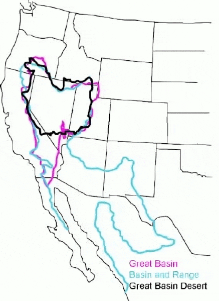
English: The Great Basin can be defined hydrographically (in purple), topographically (in blue), or biologically (in black). |
| Petsa | (UTC) |
| Ginkuhaan |
This file was derived from: GB-Definition-Map.jpg:  |
| Awtor |
|
Palilisensya:
Original:
| This image or media file contains material based on a work of a National Park Service employee, created as part of that person's official duties. As a work of the U.S. federal government, such work is in the public domain in the United States. See the NPS website and NPS copyright policy for more information. |
Cleanup:
| This file is made available under the Creative Commons CC0 1.0 Universal Public Domain Dedication. | |
| The person who associated a work with this deed has dedicated the work to the public domain by waiving all of their rights to the work worldwide under copyright law, including all related and neighboring rights, to the extent allowed by law. You can copy, modify, distribute and perform the work, even for commercial purposes, all without asking permission.
|
Original upload log
This image is a derivative work of the following images:
- File:GB-Definition-Map.jpg licensed with PD-USGov-NPS
- 2008-01-02T14:23:51Z Psemper 286x392 (17013 Bytes) {{Information |Description= |Source=http://en.wikipedia.org/wiki/Image:GB-Definition-Map.jpg |Date= |Author= |Permission= |other_versions= }}
Uploaded with derivativeFX
Kaagi han paypay
Pidlita an adlaw/oras para makit-an an fayl nga naggawas hito nga oras.
| Pitsa/Oras | Thumbnail | Mga dimensyon | Gumaramit | Komento | |
|---|---|---|---|---|---|
| waray pa kasasapawi | 05:38, 23 Marso 2024 | | 572 × 784 (50 nga KB) | Hike395 | optimize gif |
| 03:39, 23 Marso 2024 |  | 572 × 784 (115 nga KB) | Hike395 | == {{int:filedesc}} == {{Information |Description={{en|The {{w|Great Basin}} can be defined hydrographically (in purple), topographically (in blue), or biologically (in black).}} |Source={{Derived from|GB-Definition-Map.jpg|display=50}} |Date=2024-03-23 03:38 (UTC) |Author=* File:GB-Definition-Map.jpg: U.S. National Park Service * cleanup: [[User:{{subst:REVISIONUSER}}|{{subst:REVISIONUSER}}]] |Permission= |other_versions= }} == {{int:license-header}} == Origi... |
Mga Sumpay
An mga nasunod nga mga pakli nasumpay hini nga paypay:
Global file usage
An masunod nga iba nga mga wiki in nagamit hini nga file:
- Paggamit ha ar.wikipedia.org
- Paggamit ha arz.wikipedia.org
- Paggamit ha ast.wikipedia.org
- Paggamit ha az.wikipedia.org
- Paggamit ha bg.wikipedia.org
- Paggamit ha ca.wikipedia.org
- Paggamit ha de.wikipedia.org
- Paggamit ha en.wikipedia.org
- Paggamit ha es.wikipedia.org
- Paggamit ha eu.wikipedia.org
- Paggamit ha gd.wikipedia.org
- Paggamit ha he.wikipedia.org
- Paggamit ha hu.wikipedia.org
- Paggamit ha hy.wikipedia.org
- Paggamit ha ja.wikipedia.org
- Paggamit ha ka.wikipedia.org
- Paggamit ha nl.wikipedia.org
- Paggamit ha pt.wikipedia.org
- Paggamit ha ro.wikipedia.org
- Paggamit ha ru.wikipedia.org
- Paggamit ha simple.wikipedia.org
- Paggamit ha sv.wikipedia.org
- Paggamit ha tr.wikipedia.org
- Paggamit ha uk.wikipedia.org
- Paggamit ha vi.wikipedia.org
- Paggamit ha www.wikidata.org