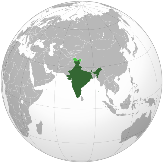
Paypay:India (orthographic projection).svg
Page contents not supported in other languages.
Tikang ha Wikipedia

Orihinal nga paypay(SVG nga fayl, ginbabanabanahan nga 541 × 541 nga mga pixel, kadako han fayl: 280 nga KB)

An fayl in tikang ha Wikimedia Commons ngan puydi mahigamitan para han iba nga mga proyekto. An paglaladawan han iya fayl han paglaladawan nga pakli didto in ginpapakita ha sirong.

Dalikyat nga pulong

Tigtulidong
English: India. Area controlled by India in dark green; claimed but not controlled areas in light green.
Petsa
Ginkuhaan

Own work,

 
This vector image was created with Inkscape .

Aquarius.geomar.de

বাংলা  English  español  français  italiano  日本語  македонски  sicilianu  中文(简体)  中文(繁體)  +/−

GNU head An permiso in ginhatag ha pagkopya, pagpakalat ngan/o pagliwat hinin nga dokumento ha ilarom han mga termino han GNU Free Documentation License, Version 1.2 o mas uruurhi nga version nga ginmantala han Free Software Foundation; nga may-ada waray Invariant Sections, waray Front-Cover Texts, ngan waray Back-Cover Texts. May-ada kopya hin lisensya nga ginlalakip ha seksyon nga may-ada pamagat nga GNU Free Documentation License.
Awtor Ssolbergj (talk)
Other versions

Derivative works of this file:

This is a Grey & green orthographic projection map.
العربية: الرجاء، قراءة الميثاق.
বাংলা: দয়া করে, রীতিনীতিটি পড়ুন
Deutsch: Bitte lies die Konventionen.
English: Please, read the conventions.
Español: Por favor, lea las convenciones.
Filipino: Paki-basa ang mga kumbensyon.
Français : S'il vous plaît, lisez les conventions.
हिन्दी: कृपया सभागमों को पढ़ लें.
Bahasa Indonesia: Silakan, baca konvensi.
Italiano: Si prega di leggere le convenzioni.
ქართული: გთხოვთ, გაეცნოთ კონვენციებს.
Português: Por favor, leia as convenções.
Русский: Пожалуйста, прочитайте соглашения.
Українська: Будь ласка, прочитайте конвенції.
Tiếng Việt: Hãy đọc công văn trước khi đăng.
World maps

Africa

हिन्दी: अफ्रीका
ქართული: აფრიკა.

Eastern Africa

Southern Africa

Central Africa

Northern Africa

Western Africa

Americas

ქართული: ამერიკა.
हिन्दी: अमेरिका

North America

Central America

Caribbean

South America

Asia

ქართული: აზია.
Português: Ásia.
Українська: Азія.

East

Português: Ásia Oriental.
Українська: Східна Азія.

Central

हिन्दी: मध्य एशिया
Português: Ásia Central.
Українська: Центральна Азія.

Southeast

Bahasa Indonesia: Asia tenggara
Português: Sudeste Asiático.

South

(भारतीय उपमहाद्वीप)
Português: Sul da Ásia.
Українська: Південна Азія.

Western

Português: Sudoeste da Ásia.
Українська: Передня Азія.

Europe

हिन्दी: यूरोप
ქართული: ევროპა.
Português: Europa.
Română: Europa.
Русский: Европа.
Українська: Європа.

Countries

Oceania

हिन्दी: ओशिआनिया
ქართული: ოკეანეთი.
Português: Oceania.
Українська: Океанія.

Intercontinental

Português: Intercontinental.
Українська: Міжконтинентальні.

Historical

English: Unions, Organizations, Kingdoms, Empires
Español: Uniones, Organizaciones, Reinos, Imperios
Filipino: Mga Unyon, Organisasyon, Kaharian, Imperyo
Français : Unions, Organisations, Royaumes, Empires
हिन्दी: संघ, संगठन, राज्य, साम्राज्य व ऐतिहासिक देश
ქართული: გაერთიანებები, ორგანიზაციები, სამეფოები, იმპერიები
Português: Estados extintos.
Tagalog: Mga Unyon, Organisasyon, Kaharian, Imperyo
Українська: Союзи, Організації, Королівства, Імперії

Subnationals

हिन्दी: उपराष्ट्रीय इकाईयाँ
Orthographic projections maps created by Ssolbergj
Orthographic projections maps created by Ssolbergj:

Palilisensya:

I, the copyright holder of this work, hereby publish it under the following licenses:
GNU head An permiso in ginhatag ha pagkopya, pagpakalat ngan/o pagliwat hinin nga dokumento ha ilarom han mga termino han GNU Free Documentation License, Version 1.2 o mas uruurhi nga version nga ginmantala han Free Software Foundation; nga may-ada waray Invariant Sections, waray Front-Cover Texts, ngan waray Back-Cover Texts. May-ada kopya hin lisensya nga ginlalakip ha seksyon nga may-ada pamagat nga GNU Free Documentation License.
w:en:Creative Commons
attribution share alike
Ini nga file in nakalisensya ha ilarom han Creative Commons Attribution-Share Alike 3.0 Unported license.
Talwas ka:
  • para han pagpasaro – para han pagkopya, pagpakalat ngan pagpadangat han buhat
  • para han pagremix – pag-adapt han buhat
Ha ilarom an masunod nga mga kondisyon:
  • attribution – Kinahanglanon mo tagan hin kaangayan nga credit, paghatag hin sumpay ngadto ha lisensya, ngan igbutang an imo ginbag-ohan nga binuhat. Puydi mo ini buhaton ha bisan ano nga resonable nga pamaagi, pero diri nimo pagawson nga an naghatag hin lisensya nag-eendorso ha imo o ha imo paggamit.
  • share alike – Kun imo ginsagol-hin-otro, gin-iba, o gin-hingayad han buhat, ikaw in angay gud là magpakalat han imo gin-amot ha ilarom la han [http:creativecommons.org/share-your-work/licensing-considerations/compatible-licenses pareho o naangay nga lisensya] sugad han orihinal.
Puydi ka pumili hin lisenysa nga karuyag mo.
{{{template}}} Warning! According to Indian law, it is illegal to produce maps that in the view of the Indian government, misrepresent Indian territories by showing areas the Indian government claims ownership of but does not control as not belonging to India or as being contested.

Captions

Add a one-line explanation of what this file represents
india

Items portrayed in this file

depicts English

copyrighted English

inception English

Nobyembre 2008

MIME type English

image/svg+xml

Kaagi han paypay

Pidlita an adlaw/oras para makit-an an fayl nga naggawas hito nga oras.

(Gibag-ohi | Giunhani) Kitaa an (burubag-o 10 | ) (10 | 20 | 50 | 100 | 250 | 500)
Pitsa/OrasThumbnailMga dimensyonGumaramitKomento
waray pa kasasapawi07:10, 26 Abril 2023Bersyon han thumbnail han 07:10, 26 Abril 2023541 × 541 (280 nga KB)Swtadi143Reverted to version as of 07:34, 16 September 2021 (UTC) siachen glacier is fully controlled by india and not india pakistan jointly, see Siachen conflict for context.
10:02, 20 Septyembre 2021Bersyon han thumbnail han 10:02, 20 Septyembre 2021512 × 512 (155 nga KB)Ytpks896Reverted to version as of 17:38, 6 September 2021 (UTC) Siachen is a disputed territory not fully controlled by single country it is controlled by both Pakistan and india & some parts by china
07:34, 16 Septyembre 2021Bersyon han thumbnail han 07:34, 16 Septyembre 2021541 × 541 (280 nga KB)Ksh.andronexusReverted to version as of 16:08, 19 December 2019 (UTC)
17:38, 6 Septyembre 2021Bersyon han thumbnail han 17:38, 6 Septyembre 2021512 × 512 (155 nga KB)MilenioscuroSiachen is a disputed territory between China, India and Pakistan
16:08, 19 Disyembre 2019Bersyon han thumbnail han 16:08, 19 Disyembre 2019541 × 541 (280 nga KB)Goran tek-enAdded border for South Sudan as requested by {{u|Maphobbyist}}
14:04, 21 Oktubre 2017Bersyon han thumbnail han 14:04, 21 Oktubre 2017541 × 541 (139 nga KB)Goran tek-enAdded Siachen Glacier as requested by {{u|King Prithviraj II}}
21:31, 12 Septyembre 2012Bersyon han thumbnail han 21:31, 12 Septyembre 2012541 × 541 (167 nga KB)PalosirkkaScrubbed with http://codedread.com/scour/
23:40, 15 Nobyembre 2009Bersyon han thumbnail han 23:40, 15 Nobyembre 2009541 × 541 (573 nga KB)Shibo77+Eritrea, Yemen; -neutral zone
13:18, 1 Nobyembre 2009Bersyon han thumbnail han 13:18, 1 Nobyembre 2009541 × 541 (496 nga KB)Pahari SahibMap showing territory governered by India, see map of Pakistan
13:17, 11 Marso 2009Bersyon han thumbnail han 13:17, 11 Marso 2009541 × 541 (572 nga KB)TryphonReverted to version as of 22:12, 13 February 2009: please use the talk page before reverting this image; there are apparently many people who want the map this way.
(Gibag-ohi | Giunhani) Kitaa an (burubag-o 10 | ) (10 | 20 | 50 | 100 | 250 | 500)

An mga nasunod nga mga pakli nasumpay hini nga paypay:

Global file usage

An masunod nga iba nga mga wiki in nagamit hini nga file:

Kitaa durudamo nga global usage hinin nga file.

Metadata