
Paypay:India Madhya Pradesh location map.svg

Size of this PNG preview of this SVG file: 800 × 563 nga mga pixel. Iba nga mga resolusyon: 320 × 225 nga mga pixel | 640 × 450 nga mga pixel | 1,024 × 720 nga mga pixel | 1,280 × 900 nga mga pixel | 2,560 × 1,800 nga mga pixel | 1,041 × 732 nga mga pixel.
Orihinal nga paypay (SVG nga fayl, ginbabanabanahan nga 1,041 × 732 nga mga pixel, kadako han fayl: 180 nga KB)
Dalikyat nga pulong
| Tigtulidong |
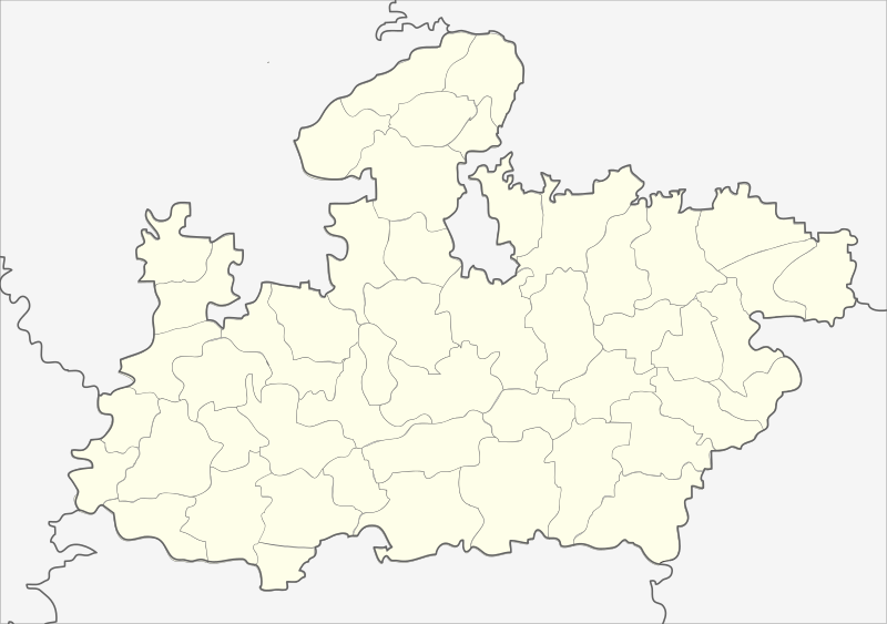
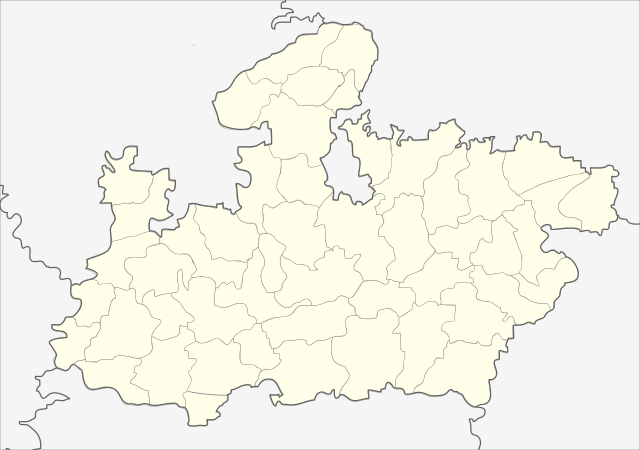
English: Locator map of Madhya Pradesh.
Geographical limits of the map:
Français : Carte de localisation du Madhya Pradesh, Inde. |
| Petsa | (UTC) |
| Ginkuhaan | India_Madhya_Pradesh_locator_map.svg |
| Awtor |
India_Madhya_Pradesh_locator_map.svg: user:Planemad
|
| Other versions |
|


| This is a retouched picture, which means that it has been digitally altered from its original version. Modifications: Cropped map of madhya pradesh. The original can be viewed here: India Madhya Pradesh locator map.svg:
|
Palilisensya:
Ini nga file in nakalisensya ha ilarom han Creative Commons Attribution-Share Alike 3.0 Unported license.
- Talwas ka:
- para han pagpasaro – para han pagkopya, pagpakalat ngan pagpadangat han buhat
- para han pagremix – pag-adapt han buhat
- Ha ilarom an masunod nga mga kondisyon:
- attribution – Kinahanglanon mo tagan hin kaangayan nga credit, paghatag hin sumpay ngadto ha lisensya, ngan igbutang an imo ginbag-ohan nga binuhat. Puydi mo ini buhaton ha bisan ano nga resonable nga pamaagi, pero diri nimo pagawson nga an naghatag hin lisensya nag-eendorso ha imo o ha imo paggamit.
- share alike – Kun imo ginsagol-hin-otro, gin-iba, o gin-hingayad han buhat, ikaw in angay gud là magpakalat han imo gin-amot ha ilarom la han [http:creativecommons.org/share-your-work/licensing-considerations/compatible-licenses pareho o naangay nga lisensya] sugad han orihinal.
Original upload log
This image is a derivative work of the following images:
- File:India_Madhya_Pradesh_locator_map.svg licensed with Cc-by-sa-3.0
- 2006-08-06T17:38:20Z Planemad 1639x1852 (768594 Bytes) {{WikiProject_India_Maps |Title=Madhya Pradesh locator map |Description=Locator map of the state of Madhya Pradesh, [[w:India|India]] with district boundaries. |Source=. |Date=August 6 2006 |Author=[[w:user:Nichalp]][[w:user
Uploaded with derivativeFX
| Annotations | This image is annotated: View the annotations at Commons |
Kaagi han paypay
Pidlita an adlaw/oras para makit-an an fayl nga naggawas hito nga oras.
| Pitsa/Oras | Thumbnail | Mga dimensyon | Gumaramit | Komento | |
|---|---|---|---|---|---|
| waray pa kasasapawi | 22:26, 25 Pebrero 2013 | | 1,041 × 732 (180 nga KB) | Milenioscuro | updated new districts, colors according german map workshop and the other India location maps |
| 12:19, 25 Nobyembre 2010 |  | 610 × 440 (146 nga KB) | Nayvik | Changed background color | |
| 12:13, 25 Nobyembre 2010 |  | 610 × 440 (146 nga KB) | Nayvik | {{Information |Description=Locator map of Madhya Pradesh.<br> Geographical limits of the map: * 28.0°N * 20.0°N * 84.0°E * 72.0°E |Source=*File:India_Madhya_Pradesh_locator_map.svg |Date=2010-11-25 12:11 (UTC) |Author=*[[:Fi |
Mga Sumpay
Waray pakli nga nagamit hinin nga file.
Global file usage
An masunod nga iba nga mga wiki in nagamit hini nga file:
- Paggamit ha de.wikipedia.org
- Paggamit ha de.wikivoyage.org
- Paggamit ha en.wikipedia.org
- Paggamit ha eo.wikipedia.org
- Paggamit ha fa.wikipedia.org
Kitaa durudamo nga global usage hinin nga file.