
Paypay:Japan natural location map with side map of the Ryukyu Islands.jpg

Kadako hin nga pahiuna nga pagawas: 664 × 600 nga mga pixel. Iba nga mga resolusyon: 266 × 240 nga mga pixel | 531 × 480 nga mga pixel | 850 × 768 nga mga pixel | 1,133 × 1,024 nga mga pixel | 2,497 × 2,256 nga mga pixel.
Orihinal nga paypay (2,497 × 2,256 nga pixel, kadako han fayl: 830 nga KB, MIME nga tipo: image/jpeg)
Dalikyat nga pulong
| Tigtulidong |
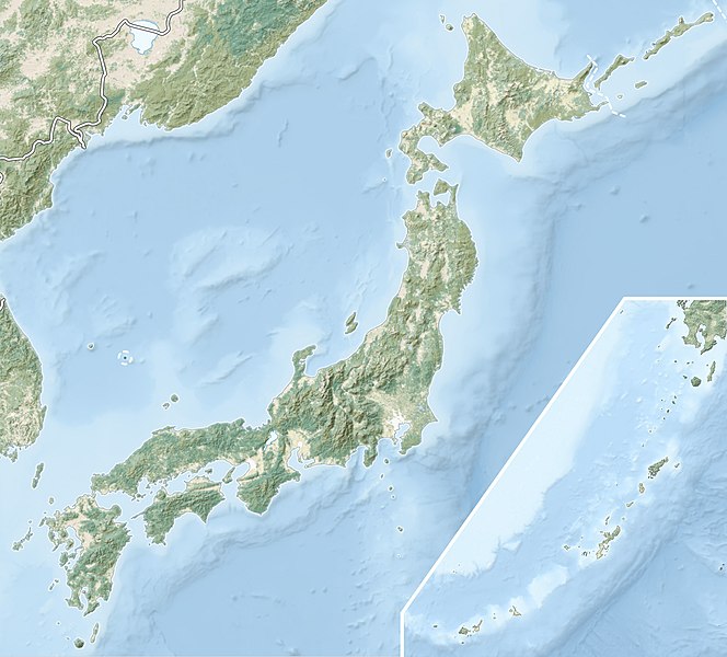
English: Natural Location map of Japan
Equirectangular projection. Geographic limits to locate objects in the main map with the main islands:
Geographic limits to locate objects in the side map with the Ryukyu Islands:
|
||
| Petsa | |||
| Ginkuhaan |
|
||
| Awtor | Alexrk2 | ||
| Pagtugot (Gin-uutro paggamit inin nga file) |
Ini nga file in nakalisensya ha ilarom han Creative Commons Attribution-Share Alike 3.0 Unported license.
|
||
| Other versions |
|


Kaagi han paypay
Pidlita an adlaw/oras para makit-an an fayl nga naggawas hito nga oras.
| Pitsa/Oras | Thumbnail | Mga dimensyon | Gumaramit | Komento | |
|---|---|---|---|---|---|
| waray pa kasasapawi | 21:41, 9 Marso 2022 | | 2,497 × 2,256 (830 nga KB) | Sting | Natural Earth land cover data for Ryukyu Islands |
| 09:44, 22 Hunyo 2018 |  | 2,497 × 2,256 (794 nga KB) | Mardetanha | Reverted to version as of 19:56, 22 March 2011 (UTC) | |
| 19:56, 22 Marso 2011 |  | 2,497 × 2,256 (794 nga KB) | Alexrk2 | RGB | |
| 19:07, 22 Marso 2011 |  | 2,497 × 2,256 (745 nga KB) | Chumwa | RGB mode | |
| 21:08, 21 Marso 2011 |  | 2,497 × 2,256 (1.54 nga MB) | Alexrk2 | == {{int:filedesc}} == {{Information |Description= {{en|Natural Location map of Japan Equirectangular projection. Geographic limits to locate objects in the main map with the main islands: * N: 45°51'37" N (45.86°N) * S: 30°01'13" N (30. |
Mga Sumpay
An mga nasunod nga mga pakli nasumpay hini nga paypay:
Global file usage
An masunod nga iba nga mga wiki in nagamit hini nga file:
- Paggamit ha ace.wikipedia.org
- Paggamit ha als.wikipedia.org
- Paggamit ha ar.wikipedia.org
- Paggamit ha arz.wikipedia.org
- Paggamit ha ast.wikipedia.org
- Paggamit ha as.wikipedia.org
- Paggamit ha azb.wikipedia.org
- Paggamit ha az.wikipedia.org
- Hokkaydo
- Kyuşu
- Fuci
- Honşu
- İtsukuşima
- Asama dağı
- Şablon:Yer xəritəsi Yaponiya
- Tohoku zəlzələsi və sunamisi (2011)
- Fukuşima-1 AES
- Böyük Hanşin zəlzələsi
- Böyük Kanto zəlzələsi
- Hoey zəlzələsi
- Mino-Ovari zəlzələsi (1891)
- Yapon çökəkliyi
- Ryukyu adaları
- Osumi boğazı
- Sanqar boğazı
- Koreya boğazı
- Tsuşima boğazı
- Harim dənizi
- Yatsuşiro dənizi
- Hiuqa dənizi
- Daxili Yapon dənizi
- Atsumi yarımadası
- Naqasaki yarımadası
- İzu yarımadası
- Simabara yarımadası
- Şiretoko yarımadası
- Nosuke yarımadası
Kitaa durudamo nga global usage hinin nga file.