
Paypay:Las Palmas-Loc.svg

Size of this PNG preview of this SVG file: 512 × 453 nga mga pixel. Iba nga mga resolusyon: 271 × 240 nga mga pixel | 543 × 480 nga mga pixel | 868 × 768 nga mga pixel | 1,157 × 1,024 nga mga pixel | 2,315 × 2,048 nga mga pixel.
Orihinal nga paypay (SVG nga fayl, ginbabanabanahan nga 512 × 453 nga mga pixel, kadako han fayl: 95 nga KB)
Dalikyat nga pulong
| Tigtulidong |
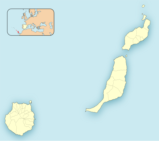
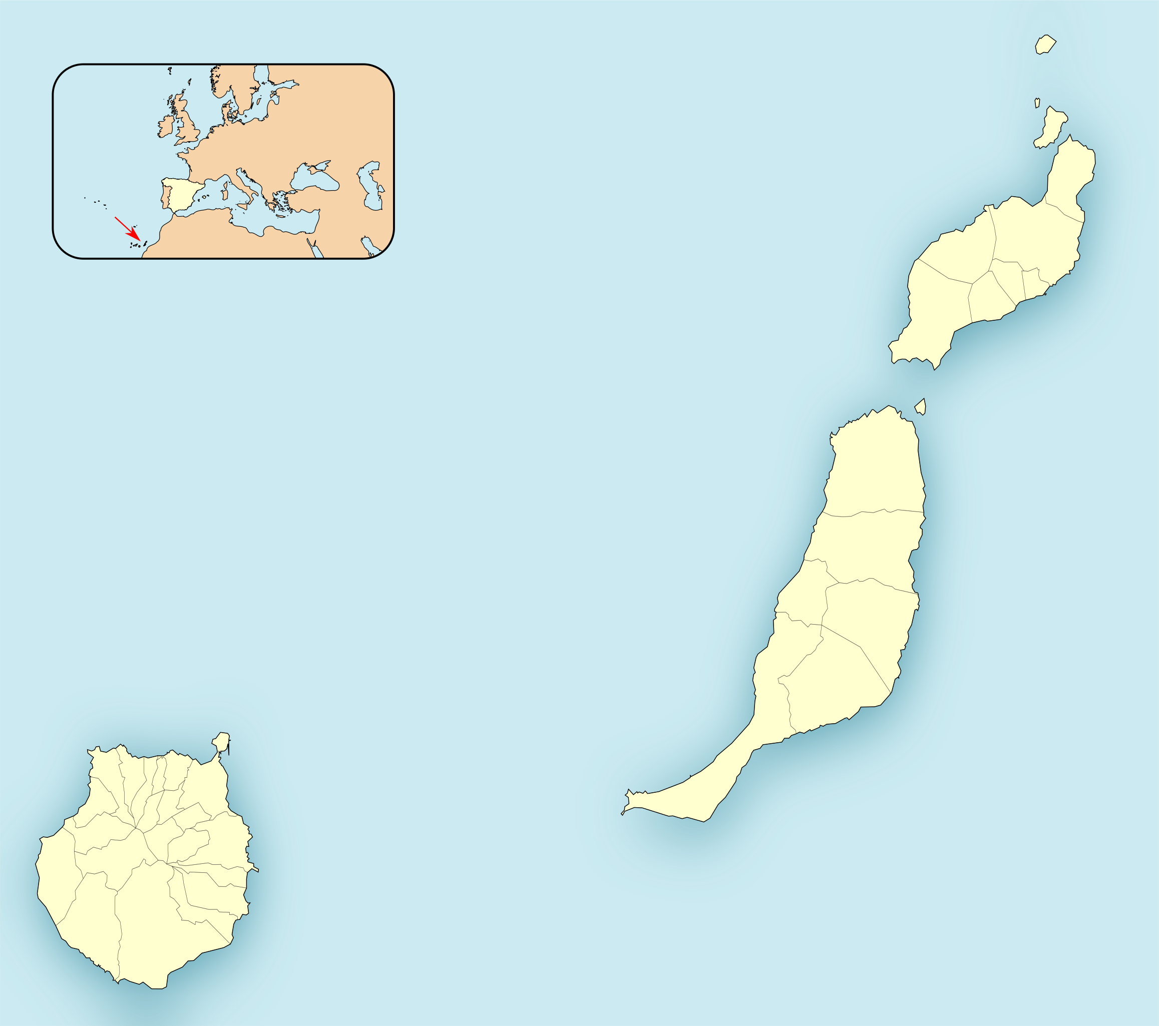
English: Location map of Province of Las Palmas
Equirectangular projection, N/S stretching 130 %. Geographic limits of the map:
Español: Mapa de localización de las Provincia de Las Palmas
Proyección equirrectangular (cilíndrica equidistante), N/S estirada 130 %. Límites geográficos del mapa:
|
|
| Petsa | ||
| Ginkuhaan | Own work based on: EspañaLoc.svg by HansenBCN | |
| Awtor | Miguillen | |
| SVG genesis | This locator map was created with Inkscape.
|
Palilisensya:
Miguillen, the copyright holder of this work, hereby publishes it under the following license:
Ini nga file in nakalisensya ha ilarom han Creative Commons Attribution-Share Alike 3.0 Unported license.
Attribution: Miguillen
- Talwas ka:
- para han pagpasaro – para han pagkopya, pagpakalat ngan pagpadangat han buhat
- para han pagremix – pag-adapt han buhat
- Ha ilarom an masunod nga mga kondisyon:
- attribution – Kinahanglanon mo tagan hin kaangayan nga credit, paghatag hin sumpay ngadto ha lisensya, ngan igbutang an imo ginbag-ohan nga binuhat. Puydi mo ini buhaton ha bisan ano nga resonable nga pamaagi, pero diri nimo pagawson nga an naghatag hin lisensya nag-eendorso ha imo o ha imo paggamit.
- share alike – Kun imo ginsagol-hin-otro, gin-iba, o gin-hingayad han buhat, ikaw in angay gud là magpakalat han imo gin-amot ha ilarom la han [http:creativecommons.org/share-your-work/licensing-considerations/compatible-licenses pareho o naangay nga lisensya] sugad han orihinal.
Kaagi han paypay
Pidlita an adlaw/oras para makit-an an fayl nga naggawas hito nga oras.
| Pitsa/Oras | Thumbnail | Mga dimensyon | Gumaramit | Komento | |
|---|---|---|---|---|---|
| waray pa kasasapawi | 17:03, 28 Hulyo 2020 | | 512 × 453 (95 nga KB) | Pedro alfred2 | Reverted to version as of 15:34, 21 November 2010 (UTC) |
| 16:15, 10 Disyembre 2010 |  | 512 × 453 (53 nga KB) | Miguillen | mosca con CCAA según convención | |
| 15:34, 21 Nobyembre 2010 |  | 512 × 453 (95 nga KB) | Miguillen | estiro un 130 % | |
| 12:10, 21 Nobyembre 2010 |  | 512 × 362 (96 nga KB) | Miguillen | == {{int:filedesc}} == {{Information |Description={{en|Location map of Province of Las Palmas}} Equirectangular projection, N/S stretching 130 %. Geographic limits of the map: * N: ° N * S: ° N * W: ° O * E: ° O {{e |
Mga Sumpay
An mga nasunod nga mga pakli nasumpay hini nga paypay:
Global file usage
An masunod nga iba nga mga wiki in nagamit hini nga file:
- Paggamit ha ar.wikipedia.org
- سانتا لوثيا دي تيراخانا
- سان بارتولومي دي تيراخانا
- أروكاس
- بويرتو ديل روساريو
- إنخينيو
- أغويميس
- غالدار
- موغان
- لا أوليفا
- باخارا
- تيغيسي
- تياس (لاس بالماس)
- سانتا بريخيدا
- سان بارتولومي (لاس بالماس)
- يايثا (لاس بالماس)
- سانتا ماريا دي غيا دي غران كناريا
- توينيخي
- تيرور (لاس بالماس)
- أنتيغوا (لاس بالماس)
- فالسيكيو دي غران كناريا
- لا ألديا دي سان نيكولاس
- مويا (لاس بالماس)
- فيغا دي سان ماتيو
- فيرغاس
- أغايتي
- تيناخو
- أريا (لاس بالماس)
- فاييسيكو
- تيخيدا
- أرتينارا
- بيتانكوريا
- قالب:Location map Spain Province of Las Palmas
- Paggamit ha ba.wikipedia.org
- Paggamit ha ceb.wikipedia.org
- Paggamit ha el.wikipedia.org
- Paggamit ha en.wikipedia.org
Kitaa durudamo nga global usage hinin nga file.