
Paypay:Location NATO 2009 blue.svg

Size of this PNG preview of this SVG file: 455 × 149 nga mga pixel. Iba nga mga resolusyon: 320 × 105 nga mga pixel | 640 × 210 nga mga pixel | 1,024 × 335 nga mga pixel | 1,280 × 419 nga mga pixel | 2,560 × 838 nga mga pixel.
Orihinal nga paypay (SVG nga fayl, ginbabanabanahan nga 455 × 149 nga mga pixel, kadako han fayl: 1.45 nga MB)
Dalikyat nga pulong
| Tigtulidong |
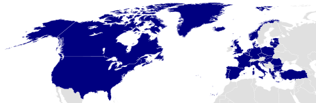
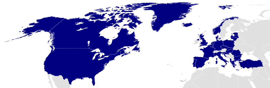
English: Member countries of NATO in blue Čeština: Členské státy NATO znázorněny modrou barvou. |
||
| Petsa | |||
| Ginkuhaan | Own work based on: Location NATO.svg by Ssolbergj | ||
| Awtor | Marco Kaiser | ||
| Pagtugot (Gin-uutro paggamit inin nga file) |
I, the copyright holder of this work, hereby publish it under the following license: This file is licensed under the Creative Commons Attribution 3.0 Unported license.
|
||
| SVG genesis |
|
Original upload log
This image is a derivative work of the following images:
- Location NATO.svg licensed with Cc-by-3.0
- 2008-05-31T19:25:16Z Ssolbergj 616x247 (584395 Bytes) {{Information |Description= |Source= |Date= |Author= |Permission= |other_versions= }}
- 2008-05-31T19:22:41Z Ssolbergj 591x297 (584395 Bytes) {{Information |Description={{en|1=Member countries of NATO}} |Source=Own work by uploader |Author=[[:en:User:Ssolbergj|Ssolbergj]] |Date=31 May 2008 |Permission= |other_versions= }} [[Category:North Atla
Uploaded with derivativeFX
Kaagi han paypay
Pidlita an adlaw/oras para makit-an an fayl nga naggawas hito nga oras.
| Pitsa/Oras | Thumbnail | Mga dimensyon | Gumaramit | Komento | |
|---|---|---|---|---|---|
| waray pa kasasapawi | 10:39, 15 Agosto 2022 | 455 × 149 (1.45 nga MB) | EmmaCoop | Reverted to version as of 05:51, 1 March 2015 (UTC); the map represents NATO as it existed in 2009 | |
| 14:06, 23 Hulyo 2022 | 455 × 149 (1.45 nga MB) | Kwamikagami | official UN blue, #009edb, update countries | ||
| 05:51, 1 Marso 2015 | 455 × 149 (1.45 nga MB) | Leftcry | Fix layout | ||
| 13:35, 2 Abril 2009 | 616 × 247 (601 nga KB) | Marco Kaiser | Made Albania and Kroatia dark blue since they are Fullmembers of the NATO since 2009-04-01 | ||
| 10:05, 6 Pebrero 2009 | 616 × 247 (599 nga KB) | Marco Kaiser | {{Information |Description={{en|1=Member countries of NATO in blue}} |Source=*File:Location_NATO.svg |Date=2009-02-06 10:04 (UTC) |Author=*File:Location_NATO.svg: Ssolbergj |Date=31 May 2008 *derivative work: ~~~ |Permis |
Mga Sumpay
Waray pakli nga nagamit hinin nga file.
Global file usage
An masunod nga iba nga mga wiki in nagamit hini nga file:
- Paggamit ha az.wikipedia.org
- Türkiyə
- Gürcüstan
- Yunanıstan
- Bolqarıstan
- Almaniya
- Rumıniya
- Portuqaliya
- Macarıstan
- Norveç
- Latviya
- Lüksemburq
- İslandiya
- İspaniya
- İtaliya
- Xorvatiya
- Fransa
- Finlandiya
- Niderland
- Danimarka
- Estoniya
- Çexiya
- Albaniya
- Belçika
- Litva
- Slovakiya
- Sloveniya
- Polşa
- Şablon:NATO
- NATO
- Kanada
- Şimali Makedoniya
- Birləşmiş Krallıq
- Böyük Britaniya və Şimali İrlandiya Birləşmiş Krallığının dövlət və siyasi sistemi
- Norveç Krallığının hüquq sistemi
- ABŞ siyasi sistemi
- NATO üzvü olan ölkələr
- NATO sammiti
- Şimali Atlantik Şurası
- Sülh Naminə Tərəfdaşlıq
- Fərdi Tərəfdaşlıq üzrə Əməliyyat Planı
- İsveç–NATO münasibətləri
- Paggamit ha bg.wikipedia.org
- Paggamit ha ckb.wikipedia.org
Kitaa durudamo nga global usage hinin nga file.