
Paypay:Map indicating Davis Strait.png
Map_indicating_Davis_Strait.png (340 × 330 nga pixel, kadako han fayl: 47 nga KB, MIME nga tipo: image/png)
Dalikyat nga pulong
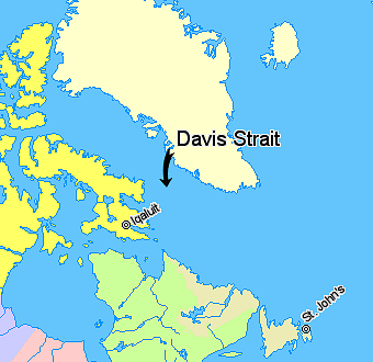
Map indicating Davis Strait, lying between Greenland and Nunavut, Canada.
© Her Majesty the Queen in Right of Canada, Department of Natural Resources. All rights reserved.
Licence Agreement
Palilisensya:

|
The copyright holder of this work allows anyone to use it for any purpose including unrestricted redistribution, commercial use, and modification.
Usage notes:
|
Kaagi han paypay
Pidlita an adlaw/oras para makit-an an fayl nga naggawas hito nga oras.
| Pitsa/Oras | Thumbnail | Mga dimensyon | Gumaramit | Komento | |
|---|---|---|---|---|---|
| waray pa kasasapawi | 11:08, 21 Marso 2006 | | 340 × 330 (47 nga KB) | David Kernow~commonswiki | Map indicating Davis Strait, lying between Nunavut, Canada and Greenland. {{legend|#ffff66|Nunavut}} {{legend|#d5fe94|Quebec}} {{legend|#ecebb6|Newfoundland and Labrador}} {{legend|#ffffcc|Regions outside Canada (Greenland, Iceland)}} |
Mga Sumpay
An mga nasunod nga mga pakli nasumpay hini nga paypay:
Global file usage
An masunod nga iba nga mga wiki in nagamit hini nga file:
- Paggamit ha be.wikipedia.org
- Paggamit ha bg.wikipedia.org
- Paggamit ha bn.wikipedia.org
- Paggamit ha bs.wikipedia.org
- Paggamit ha cs.wikipedia.org
- Paggamit ha da.wikipedia.org
- Paggamit ha de.wikipedia.org
- Paggamit ha el.wikipedia.org
- Paggamit ha en.wikipedia.org
- Paggamit ha eo.wikipedia.org
- Paggamit ha fi.wikipedia.org
- Paggamit ha fy.wikipedia.org
- Paggamit ha he.wikipedia.org
- Paggamit ha hr.wikipedia.org
- Paggamit ha id.wikipedia.org
- Paggamit ha is.wikipedia.org
- Paggamit ha it.wikipedia.org
- Paggamit ha ja.wikipedia.org
- Paggamit ha ko.wikipedia.org
- Paggamit ha ku.wikipedia.org
- Paggamit ha la.wikipedia.org
- Paggamit ha lt.wikipedia.org
- Paggamit ha ml.wikipedia.org
- Paggamit ha nn.wikipedia.org
- Paggamit ha pa.wikipedia.org
- Paggamit ha pl.wikipedia.org
- Paggamit ha pnb.wikipedia.org
- Paggamit ha pt.wikipedia.org
- Paggamit ha ro.wikipedia.org
- Paggamit ha sh.wikipedia.org
- Paggamit ha simple.wikipedia.org
- Paggamit ha sk.wikipedia.org
- Paggamit ha sr.wikipedia.org
- Paggamit ha sv.wikipedia.org
- Paggamit ha sw.wikipedia.org
- Paggamit ha th.wikipedia.org
- Paggamit ha tr.wikipedia.org
- Paggamit ha uk.wikipedia.org
- Paggamit ha ur.wikipedia.org
- Paggamit ha vi.wikipedia.org
- Paggamit ha xmf.wikipedia.org
- Paggamit ha zh-min-nan.wikipedia.org