
Paypay:MiyazakiMapCurrent.png

Kadako hin nga pahiuna nga pagawas: 533 × 600 nga mga pixel. Iba nga mga resolusyon: 213 × 240 nga mga pixel | 427 × 480 nga mga pixel | 801 × 901 nga mga pixel.
Orihinal nga paypay (801 × 901 nga pixel, kadako han fayl: 30 nga KB, MIME nga tipo: image/png)

|
This locator map image could be re-created using vector graphics as an SVG file. This has several advantages; see Commons:Media for cleanup for more information. If an SVG form of this image is available, please upload it and afterwards replace this template with
{{vector version available|new image name}}.
It is recommended to name the SVG file “MiyazakiMapCurrent.svg”—then the template Vector version available (or Vva) does not need the new image name parameter. |
Dalikyat nga pulong
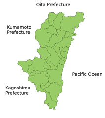
Map of Miyazaki Prefecture, Japan.
Thanks to Aoki Shigenobu and [1]. Colors from Image:TokyoMapCurrent.png by User:Fg2.
Palilisensya:
| I, the copyright holder of this work, release this work into the public domain. This applies worldwide. In some countries this may not be legally possible; if so: I grant anyone the right to use this work for any purpose, without any conditions, unless such conditions are required by law. |
Kaagi han paypay
Pidlita an adlaw/oras para makit-an an fayl nga naggawas hito nga oras.
| Pitsa/Oras | Thumbnail | Mga dimensyon | Gumaramit | Komento | |
|---|---|---|---|---|---|
| waray pa kasasapawi | 19:24, 22 Marso 2010 | | 801 × 901 (30 nga KB) | Alberth2 | Nojiri Town was mereged into Kobayashi City and Kiyotake Town was mereged into Miyazaki City. |
| 08:01, 31 Marso 2009 |  | 801 × 901 (31 nga KB) | Alberth2 | Nangou-chō, Kitagou-chō and Nichinan-shi were megred. | |
| 07:34, 26 Septyembre 2008 |  | 801 × 901 (31 nga KB) | Alberth2 | Kitagawa was merged into Nobeoka. | |
| 23:59, 23 Hulyo 2006 |  | 801 × 901 (30 nga KB) | Akanemoto~commonswiki | ||
| 15:47, 22 Hulyo 2006 |  | 801 × 901 (31 nga KB) | Akanemoto~commonswiki | ||
| 02:00, 22 Hulyo 2006 |  | 801 × 901 (31 nga KB) | Akanemoto~commonswiki | ||
| 21:25, 21 Hulyo 2006 |  | 981 × 901 (32 nga KB) | Akanemoto~commonswiki | Map of Miyazaki Prefecture, Japan. Thanks to Aoki Shigenobu and [http://aoki2.si.gunma-u.ac.jp/map/map.html]. Colors from Image:TokyoMapCurrent.png by User:Fg2. Category:Maps of Miyazaki prefecture Category:Maps in English |
Mga Sumpay
Waray pakli nga nagamit hinin nga file.
Global file usage
An masunod nga iba nga mga wiki in nagamit hini nga file:
- Paggamit ha az.wikipedia.org
- Paggamit ha ckb.wikipedia.org
- Paggamit ha cs.wikipedia.org
- Paggamit ha fa.wikipedia.org
- Paggamit ha fr.wikipedia.org
- Paggamit ha ilo.wikipedia.org
- Paggamit ha incubator.wikimedia.org
- Paggamit ha lt.wikipedia.org
- Paggamit ha ms.wikipedia.org
- Paggamit ha no.wikipedia.org
- Paggamit ha pam.wikipedia.org
- Paggamit ha pl.wikipedia.org
- Paggamit ha ru.wikipedia.org
- Paggamit ha sah.wikipedia.org
- Paggamit ha su.wikipedia.org
- Paggamit ha vi.wikipedia.org