
Paypay:Nagpur.png
Kadako hin nga pahiuna nga pagawas: 800 × 551 nga mga pixel. Iba nga mga resolusyon: 320 × 220 nga mga pixel | 640 × 441 nga mga pixel | 1,024 × 705 nga mga pixel | 1,440 × 992 nga mga pixel.
Orihinal nga paypay (1,440 × 992 nga pixel, kadako han fayl: 282 nga KB, MIME nga tipo: image/png)
Dalikyat nga pulong
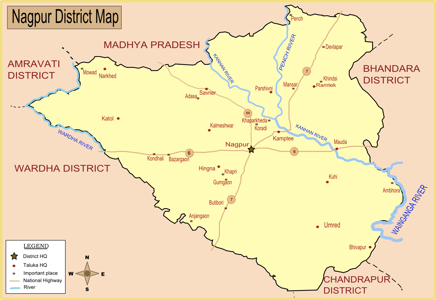
| Tigtulidong | Map of Nagpur district with major towns and rivers. I have created this map by taking reference from Nagpur district collector's website. |
| Petsa | |
| Ginkuhaan | Kalugaringon nga buhat |
| Awtor | Wikigringo |
| Pagtugot (Gin-uutro paggamit inin nga file) |
Please site my name in case of reuse or any other use. |
Palilisensya:
I, the copyright holder of this work, hereby publish it under the following licenses:

|
An permiso in ginhatag ha pagkopya, pagpakalat ngan/o pagliwat hinin nga dokumento ha ilarom han mga termino han GNU Free Documentation License, Version 1.2 o mas uruurhi nga version nga ginmantala han Free Software Foundation; nga may-ada waray Invariant Sections, waray Front-Cover Texts, ngan waray Back-Cover Texts. May-ada kopya hin lisensya nga ginlalakip ha seksyon nga may-ada pamagat nga GNU Free Documentation License. |
This file is licensed under the Creative Commons Attribution-Share Alike Attribution-Share Alike 4.0 International, 3.0 Unported, 2.5 Generic, 2.0 Generic and 1.0 Generic license.
- Talwas ka:
- para han pagpasaro – para han pagkopya, pagpakalat ngan pagpadangat han buhat
- para han pagremix – pag-adapt han buhat
- Ha ilarom an masunod nga mga kondisyon:
- attribution – Kinahanglanon mo tagan hin kaangayan nga credit, paghatag hin sumpay ngadto ha lisensya, ngan igbutang an imo ginbag-ohan nga binuhat. Puydi mo ini buhaton ha bisan ano nga resonable nga pamaagi, pero diri nimo pagawson nga an naghatag hin lisensya nag-eendorso ha imo o ha imo paggamit.
- share alike – Kun imo ginsagol-hin-otro, gin-iba, o gin-hingayad han buhat, ikaw in angay gud là magpakalat han imo gin-amot ha ilarom la han [http:creativecommons.org/share-your-work/licensing-considerations/compatible-licenses pareho o naangay nga lisensya] sugad han orihinal.
Puydi ka pumili hin lisenysa nga karuyag mo.
Kaagi han paypay
Pidlita an adlaw/oras para makit-an an fayl nga naggawas hito nga oras.
| Pitsa/Oras | Thumbnail | Mga dimensyon | Gumaramit | Komento | |
|---|---|---|---|---|---|
| waray pa kasasapawi | 09:33, 24 Enero 2008 | | 1,440 × 992 (282 nga KB) | Wikigringo | Added all Taluka headquarters along with major places. Added legend. need to add railway, airport now. Source of this map: Nagpur District collector's website. |
| 08:27, 23 Enero 2008 |  | 1,053 × 725 (162 nga KB) | Wikigringo | I have added Ramtek, and also added major national highways in the map. | |
| 08:50, 21 Enero 2008 |  | 1,041 × 733 (95 nga KB) | Wikigringo | {{Information |Description=Map of Nagpur district with major towns and rivers. I have created this map by taking reference from Nagpur district collector's website. |Source=self-made |Date=21-Jan-2008 |Author= Wikigringo |Permission=Pl |
Mga Sumpay
An mga nasunod nga mga pakli nasumpay hini nga paypay:
Global file usage
An masunod nga iba nga mga wiki in nagamit hini nga file:
- Paggamit ha af.wikipedia.org
- Paggamit ha ar.wikipedia.org
- Paggamit ha bn.wikipedia.org
- Paggamit ha ca.wikipedia.org
- Paggamit ha ceb.wikipedia.org
- Paggamit ha da.wikipedia.org
- Paggamit ha en.wikipedia.org
- Paggamit ha fa.wikipedia.org
- Paggamit ha fr.wikipedia.org
- Paggamit ha id.wikipedia.org
- Paggamit ha kn.wikipedia.org
- Paggamit ha ml.wikipedia.org
- Paggamit ha mr.wikipedia.org
- Paggamit ha nl.wikipedia.org
- Paggamit ha no.wikipedia.org
- Paggamit ha sat.wikipedia.org
- Paggamit ha sv.wikipedia.org
- Paggamit ha ta.wikipedia.org
- Paggamit ha te.wikipedia.org
- Paggamit ha tr.wikipedia.org
Kitaa durudamo nga global usage hinin nga file.