
Paypay:Non-Native-American-Nations-Territorial-Claims-over-NAFTA-countries-1750-2008.gif
Kadako hin nga pahiuna nga pagawas: 536 × 600 nga mga pixel. Iba nga mga resolusyon: 214 × 240 nga mga pixel | 429 × 480 nga mga pixel | 670 × 750 nga mga pixel.
Orihinal nga paypay (670 × 750 nga pixel, kadako han fayl: 741 nga KB, MIME nga tipo: image/gif, naka-loop, 97 frames, 1 min 56 s)
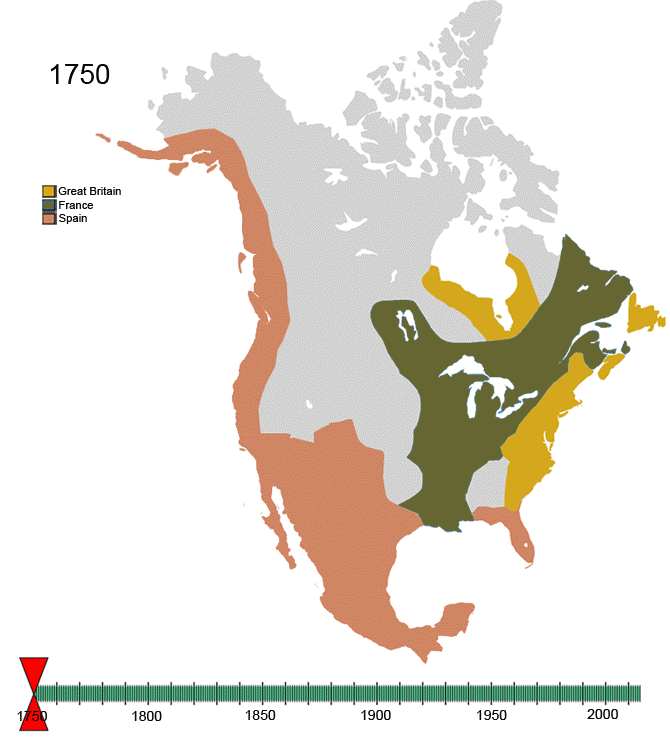
For notes on the individual border changes see Territorial evolution of North America. To make your own animated image use the slides below:
| France | |||
| Present day Canada | |||
|---|---|---|---|
| Canada | |||
| Dominion of Newfoundland | |||
| France | |||
| Britain | |||
| Present day USA | |||
| United States of America | |||
| California Republic | |||
| Confederate States of America | |||
| France | |||
| Republic of Indian Stream | No flag | ||
| Republic of Texas | |||
| Republic of Vermont | |||
| Republic of West Florida | |||
| Russia | |||
| Spain | |||
| Britain | |||
| Present day Mexico | |||
| Federal Republic of Central America | |||
| Mexico | |||
| Spain | |||
| Republic of the Rio Grande | |||
| Yucatán | |||
Images


See Also
-
 |North America
 -
 |Central America
 -
 |Balkans
 -
 |South America
 -

-

-


Dalikyat nga pulong
| Tigtulidong | Non-Native-American Nation's Control over North America circa 1750-2008 | ||
| Petsa | Created March, 2008 | ||
| Ginkuhaan | Kalugaringon nga buhat | ||
| Awtor | Esemono | ||
| Pagtugot (Gin-uutro paggamit inin nga file) |
|
Kaagi han paypay
Pidlita an adlaw/oras para makit-an an fayl nga naggawas hito nga oras.
| Pitsa/Oras | Thumbnail | Mga dimensyon | Gumaramit | Komento | |
|---|---|---|---|---|---|
| waray pa kasasapawi | 14:32, 21 Enero 2010 | | 670 × 750 (741 nga KB) | Esemono | See talk page |
| 16:14, 19 Enero 2010 |  | 700 × 783 (537 nga KB) | Maps & Lucy | Correct version by same uploader which also exists as a different file. The Spanish explored but did not CLAIM the Pacific coast all the way up to the Russians. Do not revert! | |
| 13:28, 17 Enero 2010 |  | 670 × 750 (741 nga KB) | Esemono | Fix mexico | |
| 12:05, 12 Enero 2010 |  | 670 × 750 (731 nga KB) | Esemono | Reverted to version as of 23:46, 3 January 2010 | |
| 01:23, 12 Enero 2010 |  | 670 × 750 (651 nga KB) | Maps & Lucy | Fixing map to make thumbnail version display | |
| 15:49, 11 Enero 2010 |  | 670 × 750 (651 nga KB) | Maps & Lucy | Reverted back to accurate image. The Spanish did not CONTROL the north Pacific strip, they just explored it and that does not count | |
| 23:46, 3 Enero 2010 |  | 670 × 750 (731 nga KB) | Esemono | Change Spanish control on the Pacific | |
| 07:45, 1 Enero 2010 |  | 670 × 750 (651 nga KB) | Esemono | Fix NWT island and UK Great Britian | |
| 01:32, 1 Enero 2010 |  | 670 × 750 (651 nga KB) | Esemono | Add pig war, and Rio Rico | |
| 13:15, 3 Disyembre 2009 |  | 670 × 750 (546 nga KB) | Esemono | timeline |
Mga Sumpay
An mga nasunod nga mga pakli nasumpay hini nga paypay:
Global file usage
An masunod nga iba nga mga wiki in nagamit hini nga file:
- Paggamit ha af.wikipedia.org
- Paggamit ha anp.wikipedia.org
- Paggamit ha ast.wikipedia.org
- Paggamit ha azb.wikipedia.org
- Paggamit ha az.wikipedia.org
- Paggamit ha be.wikipedia.org
- Paggamit ha bg.wikipedia.org
- Paggamit ha ca.wikipedia.org
- Paggamit ha ce.wikipedia.org
- Paggamit ha cs.wikipedia.org
- Paggamit ha da.wikipedia.org
- Paggamit ha de.wikipedia.org
- Paggamit ha el.wikipedia.org
- Paggamit ha en.wikipedia.org
- History of the Americas
- First Nations in Canada
- List of conflicts in North America
- Talk:History of the Northwest Territories
- List of land borders with dates of establishment
- User:Esemono/NorthAmerica
- Territorial evolution of North America since 1763
- User:Kazkaskazkasako/Books/History
- Wikipedia:Village pump (technical)/Archive 110
- List of conflicts in Mexico
- User:SomeGuyWhoRandomlyEdits/List of conflicts in Mexico
- Paggamit ha en.wikiquote.org
- Paggamit ha es.wikipedia.org
- Paggamit ha fa.wikipedia.org
- Paggamit ha fiu-vro.wikipedia.org
- Paggamit ha fr.wikipedia.org
- Paggamit ha gan.wikipedia.org
- Paggamit ha gl.wikipedia.org
- Paggamit ha hi.wikipedia.org
- Paggamit ha hr.wikipedia.org
- Paggamit ha hu.wikipedia.org
- Paggamit ha hy.wikipedia.org
- Paggamit ha id.wikipedia.org
- Paggamit ha ja.wikipedia.org
- Paggamit ha ka.wikipedia.org
Kitaa durudamo nga global usage hinin nga file.