Paypay:North America second level political division 2.svg

Page contents not supported in other languages.
Tikang ha Wikipedia

Orihinal nga paypay(SVG nga fayl, ginbabanabanahan nga 512 × 596 nga mga pixel, kadako han fayl: 132 nga KB)

An fayl in tikang ha Wikimedia Commons ngan puydi mahigamitan para han iba nga mga proyekto. An paglaladawan han iya fayl han paglaladawan nga pakli didto in ginpapakita ha sirong.

Dalikyat nga pulong

Tigtulidong
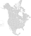
English: Map of North America and its second-level political divisions. Canadian provinces, US and Mexican states. Canada, Mexico, United States.

Non-contiguous parts of a states/provinces are "grouped" together with the main area of the state/provinces, so any state/provinces can be coloured in completion with one click anywhere on the state/provinces's area.

Also, all states/provinces have a "id" attached to them, making them easy to find. Select "find" and then enter in the state/provinces's ISO 3166-2 code in the "id" field to find it. The codes can be found here (Canada), here (USA) and here (Mexico).
Petsa
Ginkuhaan

Canada and US map: BlankMap-USA-states-Canada-provinces, HI closer.svg by Lokal_Profil.
Mexico map: Mexico template.svg by Mario Fuente Cid
Combined by Alex Covarrubias.

 
The SVG code is valid.
 
This vector image was created with Inkscape, and then manually edited
.
 
W3C-validity not checked.
Awtor Alex Covarrubias
Pagtugot
(Gin-uutro paggamit inin nga file)
w:en:Creative Commons
attribution share alike
This file is licensed under the Creative Commons Attribution-Share Alike 2.5 Generic license.
Talwas ka:
  • para han pagpasaro – para han pagkopya, pagpakalat ngan pagpadangat han buhat
  • para han pagremix – pag-adapt han buhat
Ha ilarom an masunod nga mga kondisyon:
  • attribution – Kinahanglanon mo tagan hin kaangayan nga credit, paghatag hin sumpay ngadto ha lisensya, ngan igbutang an imo ginbag-ohan nga binuhat. Puydi mo ini buhaton ha bisan ano nga resonable nga pamaagi, pero diri nimo pagawson nga an naghatag hin lisensya nag-eendorso ha imo o ha imo paggamit.
  • share alike – Kun imo ginsagol-hin-otro, gin-iba, o gin-hingayad han buhat, ikaw in angay gud là magpakalat han imo gin-amot ha ilarom la han [http:creativecommons.org/share-your-work/licensing-considerations/compatible-licenses pareho o naangay nga lisensya] sugad han orihinal.
Other versions

Derivative works of this file:

Captions

Add a one-line explanation of what this file represents

Items portrayed in this file

depicts English

copyrighted English

inception English

7 Oktubre 2007

Kaagi han paypay

Pidlita an adlaw/oras para makit-an an fayl nga naggawas hito nga oras.

Pitsa/OrasThumbnailMga dimensyonGumaramitKomento
waray pa kasasapawi01:51, 23 Nobyembre 2020Bersyon han thumbnail han 01:51, 23 Nobyembre 2020512 × 596 (132 nga KB)Ponderosapine210Added the prominent islands of Manitoulin (Ontario) and Isle Royale (Michigan) to the Great Lakes.
23:07, 1 Hunyo 2019Bersyon han thumbnail han 23:07, 1 Hunyo 2019512 × 596 (130 nga KB)Fluffy89502added territories, made DC visible, adjusted mexican borders
12:23, 4 Abril 2014Bersyon han thumbnail han 12:23, 4 Abril 20141,712 × 1,992 (270 nga KB)Lommesmade the borders between the mexican subdivisions the same size as their canadian / us counterparts.
23:23, 8 Disyembre 2007Bersyon han thumbnail han 23:23, 8 Disyembre 20071,712 × 1,992 (327 nga KB)Lokal ProfilCode cleanup
07:55, 7 Oktubre 2007Bersyon han thumbnail han 07:55, 7 Oktubre 20071,712 × 1,992 (342 nga KB)AlexCovarrubias== Summary == {{Information |Description=Map of North America and its second-level political divisions. Canadian provinces, US and Mexican states. Canada, Mexico, United States. |Source=Canada and US map by Alan Rockefeller. Mexico map by Alex Covarrubias

Waray pakli nga nagamit hinin nga file.

Global file usage

Metadata