
Paypay:Outline-Archangelskaya.png

Kadako hin nga pahiuna nga pagawas: 342 × 599 nga mga pixel. Iba nga mga resolusyon: 137 × 240 nga mga pixel | 472 × 827 nga mga pixel.
Orihinal nga paypay (472 × 827 nga pixel, kadako han fayl: 202 nga KB, MIME nga tipo: image/png)
Dalikyat nga pulong
| Tigtulidong |
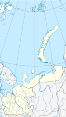
Русский: Административная карта Архангельской области, включая Ненецкий автономный округ, Новая Земля, Земля Франца-Иосифа.
English: Administrative map of Arkhangelsk Oblast, including Nenets Autonomous Okrug, Novaya Zemlya and Franz Josef Land.
|
| Petsa | |
| Ginkuhaan |
|
| Awtor | Nzeemin |
| Other versions |
|

Palilisensya:
| Description |
This map was created from OpenStreetMap project data, collected by the community. This map may be incomplete, and may contain errors. Don't rely solely on it for navigation. |
| Petsa | (see file history) |
| Ginkuhaan | openstreetmap.org |
| Creator |
OpenStreetMap contributors |
| Pagtugot (Gin-uutro paggamit inin nga file) |
OpenStreetMap data and maps are licensed under the Creative Commons Attribution-ShareAlike 2.0 license (CC-BY-SA 2.0). This file is licensed under the Creative Commons Attribution-Share Alike 2.0 Generic license.
|
| Georeferencing | If inappropriate please set warp_status = skip to hide. |
Kaagi han paypay
Pidlita an adlaw/oras para makit-an an fayl nga naggawas hito nga oras.
| Pitsa/Oras | Thumbnail | Mga dimensyon | Gumaramit | Komento | |
|---|---|---|---|---|---|
| waray pa kasasapawi | 18:38, 5 Marso 2012 | | 472 × 827 (202 nga KB) | Nzeemin |
Mga Sumpay
An mga nasunod nga mga pakli nasumpay hini nga paypay:
Global file usage
An masunod nga iba nga mga wiki in nagamit hini nga file:
- Paggamit ha ar.wikipedia.org
- Paggamit ha az.wikipedia.org
- Paggamit ha ba.wikipedia.org
- Paggamit ha be.wikipedia.org
- Архангельск
- Няндама
- Бялуш’я Губа
- Северадзвінск
- Анега (горад)
- Вельск
- Каргапаль
- Каражма
- Котлас
- Мязень (горад)
- Мірны (Архангельская вобласць)
- Навадзвінск
- Сальвычагодск
- Шэнкурск
- Шаблон:На карце/Расія Архангельская вобласць
- Малашуйка
- Емца (пасёлак)
- Плясецк (пасёлак гарадскога тыпу)
- Самадзед
- Верхняя Тойма
- Ерцава
- Краснаборск (Архангельская вобласць)
- Абазерскі
- Каменка (Архангельская вобласць)
- Кулой (рабочы пасёлак)
- Акцябрскі (Архангельская вобласць)
- Шыпіцына (Котласкі раён)
- Савінскі (Архангельская вобласць)
- Пінега (Архангельская вобласць)
- Карпагары
- Холмагары
- Урдама
- Лешуконскае (сяло)
- Ільінска-Подамскае
- Рагачова (Архангельская вобласць)
- Paggamit ha ceb.wikipedia.org
- Paggamit ha ce.wikipedia.org
Kitaa durudamo nga global usage hinin nga file.