
Paypay:Ph Bangsamoro Autonomous Region.png

Kadako hin nga pahiuna nga pagawas: 800 × 455 nga mga pixel. Iba nga mga resolusyon: 320 × 182 nga mga pixel | 640 × 364 nga mga pixel | 1,024 × 582 nga mga pixel | 1,280 × 727 nga mga pixel | 2,560 × 1,454 nga mga pixel | 3,654 × 2,076 nga mga pixel.
Orihinal nga paypay (3,654 × 2,076 nga pixel, kadako han fayl: 703 nga KB, MIME nga tipo: image/png)
Dalikyat nga pulong
| Tigtulidong |
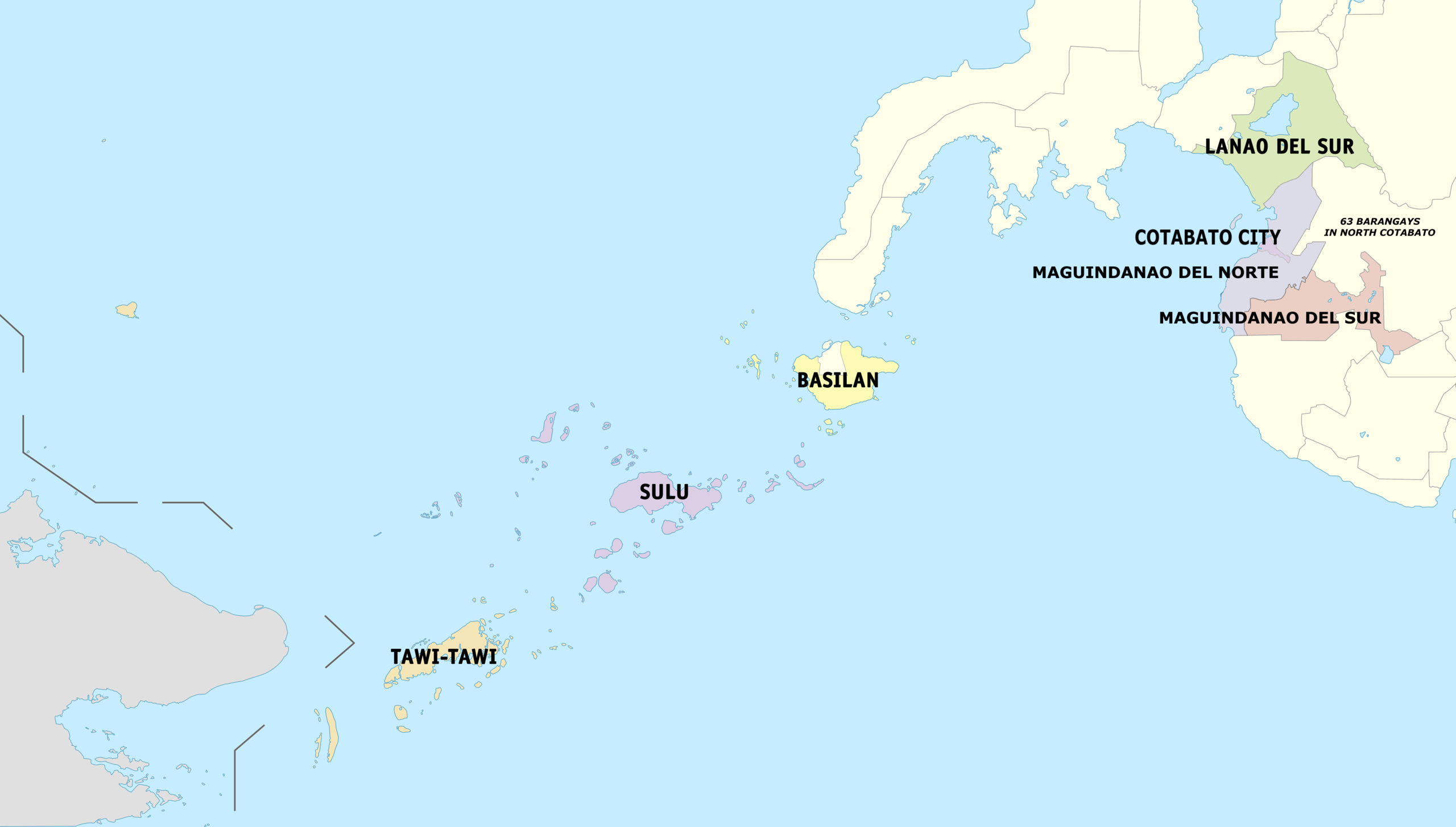
English: Political map of the Bangsamoro Autonomous Region in Muslim Mindanao. |
| Petsa | |
| Ginkuhaan | Kalugaringon nga buhat |
| Awtor | Hariboneagle927 |

|
File:Map of Bangsamoro (local government units).svg is a vector version of this file. It should be used in place of this PNG file when not inferior.
File:Ph Bangsamoro Autonomous Region.png → File:Map of Bangsamoro (local government units).svg
For more information, see Help:SVG. |
.svg) |
Palilisensya:
I, the copyright holder of this work, hereby publish it under the following license:
Ini nga file in nakalisensya ha ilarom han Creative Commons Attribution-Share Alike 3.0 Unported license.
- Talwas ka:
- para han pagpasaro – para han pagkopya, pagpakalat ngan pagpadangat han buhat
- para han pagremix – pag-adapt han buhat
- Ha ilarom an masunod nga mga kondisyon:
- attribution – Kinahanglanon mo tagan hin kaangayan nga credit, paghatag hin sumpay ngadto ha lisensya, ngan igbutang an imo ginbag-ohan nga binuhat. Puydi mo ini buhaton ha bisan ano nga resonable nga pamaagi, pero diri nimo pagawson nga an naghatag hin lisensya nag-eendorso ha imo o ha imo paggamit.
- share alike – Kun imo ginsagol-hin-otro, gin-iba, o gin-hingayad han buhat, ikaw in angay gud là magpakalat han imo gin-amot ha ilarom la han [http:creativecommons.org/share-your-work/licensing-considerations/compatible-licenses pareho o naangay nga lisensya] sugad han orihinal.
Kaagi han paypay
Pidlita an adlaw/oras para makit-an an fayl nga naggawas hito nga oras.
| Pitsa/Oras | Thumbnail | Mga dimensyon | Gumaramit | Komento | |
|---|---|---|---|---|---|
| waray pa kasasapawi | 05:51, 18 Septyembre 2022 | | 3,654 × 2,076 (703 nga KB) | Maanshen | Due to the succesion of the 2022 Maguindanao division plebiscite, The province of Maguindanao is divided into two provinces |
| 08:36, 26 Nobyembre 2021 |  | 3,654 × 2,076 (629 nga KB) | Nissan2020 | Reverted to version as of 01:13, 18 February 2019 (UTC) | |
| 03:49, 26 Nobyembre 2021 |  | 4,000 × 2,056 (535 nga KB) | Nissan2020 | Reverted to version as of 11:39, 28 March 2021 (UTC) | |
| 08:56, 30 Marso 2021 |  | 3,654 × 2,076 (629 nga KB) | HueMan1 | Reverted to version as of 15:32, 14 May 2020 (UTC) | |
| 11:39, 28 Marso 2021 |  | 4,000 × 2,056 (535 nga KB) | Teamayuiyui | Update from 2021 | |
| 15:32, 14 Mayo 2020 |  | 3,654 × 2,076 (629 nga KB) | HueMan1 | Reverted to version as of 01:13, 18 February 2019 (UTC) | |
| 01:13, 18 Pebrero 2019 |  | 3,654 × 2,076 (629 nga KB) | Hariboneagle927 | Plus 63 barangays in North Cotabato. Can't find an accurate barangay maps at the moment. And this is just a provisional edit. | |
| 12:09, 26 Enero 2019 |  | 3,654 × 2,076 (621 nga KB) | Hariboneagle927 | User created page with UploadWizard |
Mga Sumpay
An mga nasunod nga mga pakli nasumpay hini nga paypay:
Global file usage
An masunod nga iba nga mga wiki in nagamit hini nga file:
- Paggamit ha bcl.wikipedia.org
- Paggamit ha bn.wikipedia.org
- Paggamit ha cbk-zam.wikipedia.org
- Paggamit ha ceb.wikipedia.org
- Paggamit ha el.wikipedia.org
- Paggamit ha fa.wikipedia.org
- Paggamit ha fr.wikipedia.org
- Paggamit ha ms.wikipedia.org
- Paggamit ha pam.wikipedia.org
- Paggamit ha tl.wikipedia.org