
Paypay:Poland location map.svg

Size of this PNG preview of this SVG file: 617 × 600 nga mga pixel. Iba nga mga resolusyon: 247 × 240 nga mga pixel | 494 × 480 nga mga pixel | 790 × 768 nga mga pixel | 1,053 × 1,024 nga mga pixel | 2,107 × 2,048 nga mga pixel | 861 × 837 nga mga pixel.
Orihinal nga paypay (SVG nga fayl, ginbabanabanahan nga 861 × 837 nga mga pixel, kadako han fayl: 213 nga KB)
Dalikyat nga pulong
| Tigtulidong |
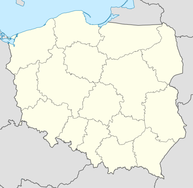
Deutsch: Positionskarte von Polen
Quadratische Plattkarte, N-S-Streckung 160 %. Geographische Begrenzung der Karte:
English: Location map of Poland
Equirectangular projection, N/S stretching 160 %. Geographic limits of the map:
|
||
| Petsa | |||
| Ginkuhaan |
Kalugaringon nga buhat using
|
||
| Awtor | NordNordWest | ||
| Other versions |
|
||
| SVG genesis | This W3C-invalid map was created with Adobe Illustrator.
|


Palilisensya:
I, the copyright holder of this work, hereby publish it under the following licenses:

|
An permiso in ginhatag ha pagkopya, pagpakalat ngan/o pagliwat hinin nga dokumento ha ilarom han mga termino han GNU Free Documentation License, Version 1.2 o mas uruurhi nga version nga ginmantala han Free Software Foundation; nga may-ada waray Invariant Sections, waray Front-Cover Texts, ngan waray Back-Cover Texts. May-ada kopya hin lisensya nga ginlalakip ha seksyon nga may-ada pamagat nga GNU Free Documentation License. |
Ini nga file in nakalisensya ha ilarom han Creative Commons Attribution-Share Alike 3.0 Unported license.
- Talwas ka:
- para han pagpasaro – para han pagkopya, pagpakalat ngan pagpadangat han buhat
- para han pagremix – pag-adapt han buhat
- Ha ilarom an masunod nga mga kondisyon:
- attribution – Kinahanglanon mo tagan hin kaangayan nga credit, paghatag hin sumpay ngadto ha lisensya, ngan igbutang an imo ginbag-ohan nga binuhat. Puydi mo ini buhaton ha bisan ano nga resonable nga pamaagi, pero diri nimo pagawson nga an naghatag hin lisensya nag-eendorso ha imo o ha imo paggamit.
- share alike – Kun imo ginsagol-hin-otro, gin-iba, o gin-hingayad han buhat, ikaw in angay gud là magpakalat han imo gin-amot ha ilarom la han [http:creativecommons.org/share-your-work/licensing-considerations/compatible-licenses pareho o naangay nga lisensya] sugad han orihinal.
Puydi ka pumili hin lisenysa nga karuyag mo.
Kaagi han paypay
Pidlita an adlaw/oras para makit-an an fayl nga naggawas hito nga oras.
| Pitsa/Oras | Thumbnail | Mga dimensyon | Gumaramit | Komento | |
|---|---|---|---|---|---|
| waray pa kasasapawi | 12:34, 2 Oktubre 2012 | | 861 × 837 (213 nga KB) | Palosirkka | Reverted to version as of 20:23, 23 November 2011 Location maps must remain very accurate |
| 20:37, 1 Oktubre 2012 |  | 861 × 837 (196 nga KB) | Palosirkka | Scrubbed with http://codedread.com/scour/ | |
| 20:23, 23 Nobyembre 2011 |  | 861 × 837 (213 nga KB) | NordNordWest | upd | |
| 11:28, 8 Disyembre 2008 |  | 862 × 838 (377 nga KB) | NordNordWest | Reverted to version as of 09:25, 8 July 2008, an often used image shouldn't be changed without discussion | |
| 09:26, 8 Disyembre 2008 |  | 862 × 838 (378 nga KB) | Mareklug | I made the featured background (territory of Poland) pure white for better contrast. | |
| 09:25, 8 Hulyo 2008 |  | 862 × 838 (377 nga KB) | NordNordWest | {{Information |Description= {{de|Positionskarte von Polen}} Quadratische Plattkarte, N-S-Streckung 160 %. Geographische Begrenzung der Karte: * N: 55.2° N * S: 48.7° N * W: 13.8° O * O: 24.5° O {{en|Location map of Poland} |
Mga Sumpay
An mga nasunod nga mga pakli nasumpay hini nga paypay:
Global file usage
An masunod nga iba nga mga wiki in nagamit hini nga file:
- Paggamit ha ar.wikipedia.org
- Paggamit ha av.wikipedia.org
- Paggamit ha bn.wikipedia.org
- Paggamit ha bs.wikipedia.org
- Paggamit ha ceb.wikipedia.org
- Paggamit ha ckb.wikipedia.org
- Paggamit ha de.wikipedia.org
- Paggamit ha diq.wikipedia.org
- Paggamit ha el.wikipedia.org
- Paggamit ha en.wikipedia.org
- Paggamit ha en.wikivoyage.org
- Paggamit ha en.wiktionary.org
- Paggamit ha eo.wikipedia.org
- Paggamit ha eo.wikivoyage.org
- Paggamit ha es.wikipedia.org
- Paggamit ha fa.wikipedia.org
- Paggamit ha fo.wikipedia.org
- Paggamit ha fr.wikipedia.org
- Paggamit ha hr.wikipedia.org
- Paggamit ha hsb.wikipedia.org
- Paggamit ha hu.wikipedia.org
Kitaa durudamo nga global usage hinin nga file.