
Paypay:Prague administrative districts.png

Kadako hin nga pahiuna nga pagawas: 776 × 600 nga mga pixel. Iba nga mga resolusyon: 311 × 240 nga mga pixel | 621 × 480 nga mga pixel | 994 × 768 nga mga pixel | 1,056 × 816 nga mga pixel.
Orihinal nga paypay (1,056 × 816 nga pixel, kadako han fayl: 33 nga KB, MIME nga tipo: image/png)
Dalikyat nga pulong
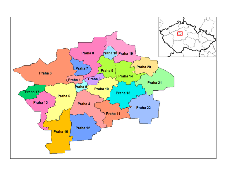
Map of the administrative districts of Prague in the Czech Republic. Created by Rarelibra 15:16, 2 January 2007 (UTC) for public domain use, using MapInfo Professional v8.5 and various mapping resources.
Palilisensya:
| I, the copyright holder of this work, release this work into the public domain. This applies worldwide. In some countries this may not be legally possible; if so: I grant anyone the right to use this work for any purpose, without any conditions, unless such conditions are required by law. |
Kaagi han paypay
Pidlita an adlaw/oras para makit-an an fayl nga naggawas hito nga oras.
| Pitsa/Oras | Thumbnail | Mga dimensyon | Gumaramit | Komento | |
|---|---|---|---|---|---|
| waray pa kasasapawi | 15:16, 2 Enero 2007 | | 1,056 × 816 (33 nga KB) | Rarelibra | Map of the administrative districts of Prague in the Czech Republic. Created by ~~~~ for public domain use, using MapInfo Professional v8.5 and various mapping resources. |
Mga Sumpay
An mga nasunod nga mga pakli nasumpay hini nga paypay:
Global file usage
An masunod nga iba nga mga wiki in nagamit hini nga file:
- Paggamit ha als.wikipedia.org
- Paggamit ha ar.wikipedia.org
- Paggamit ha bg.wikipedia.org
- Paggamit ha br.wikipedia.org
- Paggamit ha bs.wikipedia.org
- Paggamit ha ca.wikipedia.org
- Paggamit ha ce.wikipedia.org
- Paggamit ha cs.wikipedia.org
- Paggamit ha da.wikipedia.org
- Paggamit ha en.wikipedia.org
- Paggamit ha es.wikipedia.org
- Paggamit ha fa.wikipedia.org
- Paggamit ha fr.wikipedia.org
- Paggamit ha ka.wikipedia.org
- Paggamit ha ko.wikipedia.org
- Paggamit ha la.wikipedia.org
- Paggamit ha lt.wikipedia.org
- Paggamit ha nl.wikipedia.org
- Paggamit ha no.wikipedia.org
- Paggamit ha or.wikipedia.org
- Paggamit ha pl.wikipedia.org
- Paggamit ha pl.wikivoyage.org
- Paggamit ha pnb.wikipedia.org
- Paggamit ha pt.wikipedia.org
- Paggamit ha ro.wikipedia.org
- Paggamit ha ru.wikipedia.org
- Paggamit ha sk.wikipedia.org
- Paggamit ha sv.wikipedia.org
- Paggamit ha uk.wikipedia.org
- Paggamit ha ur.wikipedia.org
- Paggamit ha vi.wikipedia.org
- Paggamit ha vls.wikipedia.org
- Paggamit ha xmf.wikipedia.org