
Paypay:SEUtahStrat.JPG

Kadako hin nga pahiuna nga pagawas: 800 × 454 nga mga pixel. Iba nga mga resolusyon: 320 × 182 nga mga pixel | 640 × 363 nga mga pixel | 1,024 × 581 nga mga pixel | 1,280 × 726 nga mga pixel | 3,161 × 1,794 nga mga pixel.
Orihinal nga paypay (3,161 × 1,794 nga pixel, kadako han fayl: 2.5 nga MB, MIME nga tipo: image/jpeg)
Dalikyat nga pulong
| Tigtulidong |
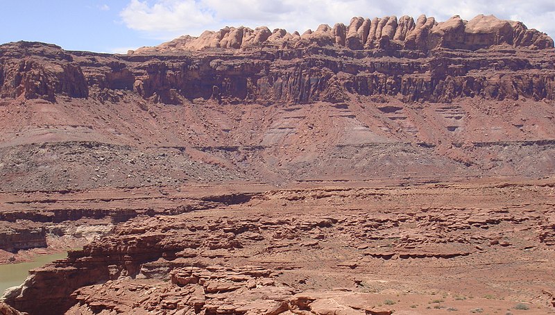
English: The Permian (bottom) through Jurassic (top) stratigraphy of the Colorado Plateau area of southeastern Utah that makes up much of the famous prominent rock formations in protected areas such as Capitol Reef National Park and Canyonlands National Park.
From top to bottom: Rounded tan domes of the Navajo Sandstone, layered red Kayenta Formation, cliff-forming, vertically-jointed, red Wingate Sandstone, slope-forming, purplish Chinle Formation, layered, lighter-red Moenkopi Formation, and white, layered Cutler Formation sandstone. Picture from Glen Canyon National Recreation Area, Utah. (modified version, 26MAY-2012, after change on en:Moenkopi Formation; changing (3) to a (3A,3B), with explanations, because of the larger photo RED debris visible.) The en:Jurassic through en:Permian stratigraphy of the Colorado Plateau area of southeastern Utah that makes up much of the famous prominent rock formations in protected areas such as Capitol Reef National Park and Canyonlands National Park. From top to bottom, (Jurassic to Permian): (6)-Rounded tan domes of the Navajo Sandstone, (5)-(very-dark)-layered red Kayenta Formation, (4)-(very-dark)-cliff-forming, vertically-jointed, red Wingate Sandstone, (3B)-(RED debris covered)-slope-forming, purplish Chinle Formation, (3A)-(NO RED Debris)-slope-forming, purplish Chinle Formation, (2)-layered, lighter-red Moenkopi Formation, and (1)-white, layered Cutler Formation sandstone. Picture from Glen Canyon National Recreation Area, Utah.)- (this makes 7 Layers, or there are 6 Layers with 3A, and 3B) |
| Petsa | (UTC) (Uploaded on Commons at 2011-03-27 17:26:30 (UTC)/Original uploaded at 2010-05-20 16:46:26) |
| Ginkuhaan | I (Matt Affolter (QFL247) (talk)) created this work entirely by myself. (Original uploaded on en.wikipedia) |
| Awtor | Matt Affolter (QFL247) (talk) (Transferred by Citypeek/Original uploaded by Matt Affolter (QFL247)) |
Palilisensya:
Matt Affolter (QFL247), the copyright holder of this work, hereby publishes it under the following licenses:
Ini nga file in nakalisensya ha ilarom han Creative Commons Attribution-Share Alike 3.0 Unported license.
Attribution: Matt Affolter (QFL247)
- Talwas ka:
- para han pagpasaro – para han pagkopya, pagpakalat ngan pagpadangat han buhat
- para han pagremix – pag-adapt han buhat
- Ha ilarom an masunod nga mga kondisyon:
- attribution – Kinahanglanon mo tagan hin kaangayan nga credit, paghatag hin sumpay ngadto ha lisensya, ngan igbutang an imo ginbag-ohan nga binuhat. Puydi mo ini buhaton ha bisan ano nga resonable nga pamaagi, pero diri nimo pagawson nga an naghatag hin lisensya nag-eendorso ha imo o ha imo paggamit.
- share alike – Kun imo ginsagol-hin-otro, gin-iba, o gin-hingayad han buhat, ikaw in angay gud là magpakalat han imo gin-amot ha ilarom la han [http:creativecommons.org/share-your-work/licensing-considerations/compatible-licenses pareho o naangay nga lisensya] sugad han orihinal.

|
An permiso in ginhatag ha pagkopya, pagpakalat ngan/o pagliwat hinin nga dokumento ha ilarom han mga termino han GNU Free Documentation License, Version 1.2 o mas uruurhi nga version nga ginmantala han Free Software Foundation; nga may-ada waray Invariant Sections, waray Front-Cover Texts, ngan waray Back-Cover Texts. May-ada kopya hin lisensya nga ginlalakip ha seksyon nga may-ada pamagat nga GNU Free Documentation License. |
Puydi ka pumili hin lisenysa nga karuyag mo.
Original upload log
The original description page was here. All following user names refer to en.wikipedia.
- 2010-05-20 16:46:26 Qfl247 3,161×1,794 (2.5 MB) ({{Information |Description = The [[Permian]] through [[Jurassic]] stratigraphy of the [[Colorado Plateau]] area of southeastern [[Utah]] that makes up much of the famous prominent rock formations in protected areas such as [[Capitol Reef National Park)
Kaagi han paypay
Pidlita an adlaw/oras para makit-an an fayl nga naggawas hito nga oras.
| Pitsa/Oras | Thumbnail | Mga dimensyon | Gumaramit | Komento | |
|---|---|---|---|---|---|
| waray pa kasasapawi | 17:27, 27 Marso 2011 | | 3,161 × 1,794 (2.5 nga MB) | Citypeek | {{BotMoveToCommons|en.wikipedia|year={{subst:CURRENTYEAR}}|month={{subst:CURRENTMONTHNAME}}|day={{subst:CURRENTDAY}}}} The upload bot is User:CommonsHelper2 Bot which is called by [http://toolserver.org/~commonshelper2/index.php CommonsHelper2]. The t |
Mga Sumpay
An mga nasunod nga mga pakli nasumpay hini nga paypay:
Global file usage
An masunod nga iba nga mga wiki in nagamit hini nga file:
- Paggamit ha ar.wikipedia.org
- Paggamit ha be-tarask.wikipedia.org
- Paggamit ha bg.wikipedia.org
- Paggamit ha bs.wikipedia.org
- Paggamit ha ca.wikipedia.org
- Paggamit ha cs.wikipedia.org
- Paggamit ha de.wikipedia.org
- Paggamit ha en.wikipedia.org
- Geology
- Sedimentary rock
- Stratigraphy
- Lithology
- Stratum
- Colorado Plateau
- Grand Staircase
- Glen Canyon National Recreation Area
- Geological formation
- Geology of the Canyonlands area
- Geology of the Capitol Reef area
- Stratigraphic unit
- Lithostratigraphy
- Principle of original horizontality
- Relative dating
- Navajo Sandstone
- Moenkopi Formation
- Chinle Formation
- Glen Canyon Group
- Wingate Sandstone
- Kayenta Formation
- Principle of lateral continuity
- Stratigraphic section
- User:Qfl247/pics
- User:Rygel, M.C./SedimentaryRock Sandbox
- User:Abyssal/Portal:Permian/Natural world articles/33
- User:Abyssal/Portal:Triassic/Natural world articles/32
- User:Abyssal/Portal:Jurassic/Natural world articles/31
- User:Abyssal/Portal:Paleogene/Natural world articles/33
- User:Abyssal/Portal:Cenozoic/Natural world articles/33
Kitaa durudamo nga global usage hinin nga file.