
Paypay:Spain Aragon location map.svg

Size of this PNG preview of this SVG file: 474 × 599 nga mga pixel. Iba nga mga resolusyon: 190 × 240 nga mga pixel | 380 × 480 nga mga pixel | 608 × 768 nga mga pixel | 810 × 1,024 nga mga pixel | 1,621 × 2,048 nga mga pixel | 512 × 647 nga mga pixel.
Orihinal nga paypay (SVG nga fayl, ginbabanabanahan nga 512 × 647 nga mga pixel, kadako han fayl: 564 nga KB)
Dalikyat nga pulong
| Tigtulidong |
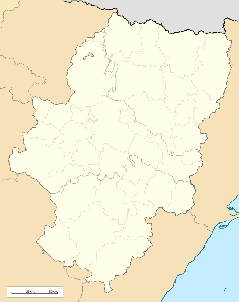
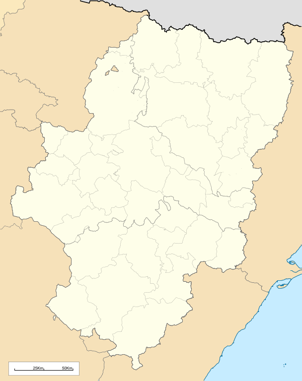
English: Location map of Aragón (Spain)
Equirectangular projection, N/S stretching 130 %. Geographic limits of the map:
Español: Mapa de localización de la comunidad autónoma de Aragón (España)
Proyección equirrectangular, N/S estirada 130 %. Límites geográficos del mapa:
|
|
| Petsa | ||
| Ginkuhaan | Own work based on: Comarcas de Aragón.svg and EspañaLoc.svg | |
| Awtor | Miguillen | |
| SVG genesis | This locator map was created with Inkscape.
|
Palilisensya:
Miguillen, the copyright holder of this work, hereby publishes it under the following license:
Ini nga file in nakalisensya ha ilarom han Creative Commons Attribution-Share Alike 3.0 Unported license.
Attribution: Miguillen
- Talwas ka:
- para han pagpasaro – para han pagkopya, pagpakalat ngan pagpadangat han buhat
- para han pagremix – pag-adapt han buhat
- Ha ilarom an masunod nga mga kondisyon:
- attribution – Kinahanglanon mo tagan hin kaangayan nga credit, paghatag hin sumpay ngadto ha lisensya, ngan igbutang an imo ginbag-ohan nga binuhat. Puydi mo ini buhaton ha bisan ano nga resonable nga pamaagi, pero diri nimo pagawson nga an naghatag hin lisensya nag-eendorso ha imo o ha imo paggamit.
- share alike – Kun imo ginsagol-hin-otro, gin-iba, o gin-hingayad han buhat, ikaw in angay gud là magpakalat han imo gin-amot ha ilarom la han [http:creativecommons.org/share-your-work/licensing-considerations/compatible-licenses pareho o naangay nga lisensya] sugad han orihinal.
Kaagi han paypay
Pidlita an adlaw/oras para makit-an an fayl nga naggawas hito nga oras.
| Pitsa/Oras | Thumbnail | Mga dimensyon | Gumaramit | Komento | |
|---|---|---|---|---|---|
| waray pa kasasapawi | 13:38, 19 Mayo 2010 | | 512 × 647 (564 nga KB) | Miguillen | bordes |
| 11:58, 19 Mayo 2010 |  | 512 × 647 (564 nga KB) | Miguillen | == {{int:filedesc}} == {{Information |Description={{en|Location map of Aragón (Spain)}} Equirectangular projection, N/S stretching 130 %. Geographic limits of the map: * N: 43.055249° N * S: 39.750129° N * W: 2.282836° O * E: 0.85 |
Mga Sumpay
An mga nasunod nga mga pakli nasumpay hini nga paypay:
Global file usage
An masunod nga iba nga mga wiki in nagamit hini nga file:
- Paggamit ha an.wikipedia.org
- Zaragoza
- Uesca
- Teruel
- Biescas
- Calatayú
- Ayerbe
- Daroca
- Chaca
- Samianigo
- Casp
- Bichuesca
- Monzón
- Munebrega
- Chasa
- Lacuna de Gallocanta
- Palacio de l'Alchafaría
- Manzanera (Teruel)
- Fraga (Uesca)
- Agüero
- Benás
- Albero d'Alto
- Alcalá de Gurrea
- Oz de Tena
- Sallent de Galligo
- Linars de Marcuello
- Val de Robres
- Calaceit
- Balbastro
- Alcanyiz
- Graus
- Albarracín
- Fuent de Todos
- Tarazona
- L'Almunia de Donya Godina
- Mont-fort
- Fuent Ferrada
- O Fornigal
- Yesero
- Pandicosa
- Candarenas
- Yebra de Basa
- Cucalón
- Villanuga
- Arinyo
- Boltanya
- Alfacharín
- Illueca
- Torrellas
- Torre la Palla
- Campiello d'Aragón
Kitaa durudamo nga global usage hinin nga file.