
Paypay:Thrace and present-day state borderlines.png

Kadako hin nga pahiuna nga pagawas: 501 × 600 nga mga pixel. Iba nga mga resolusyon: 200 × 240 nga mga pixel | 593 × 710 nga mga pixel.
Orihinal nga paypay (593 × 710 nga pixel, kadako han fayl: 142 nga KB, MIME nga tipo: image/png)
Dalikyat nga pulong
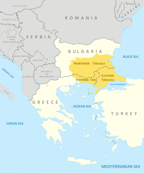
| Description |
English: Thrace and present-day state borderlines
Български: Тракия и съвременните държавни граници |
|||||||||
| Petsa | ||||||||||
| Ginkuhaan | File:Thrace modern state boundaries.png | |||||||||
| Creator | ||||||||||
| Geotemporal data | ||||||||||
| Bounding box |
|
|||||||||
| Georeferencing | ||||||||||
| Other versions | File:Thrace modern state boundaries.png, File:Thrace and present-day state borderlines zh.png, File:Thrace and present-day state borderlines-ar.png | |||||||||
Palilisensya:
I, the copyright holder of this work, hereby publish it under the following licenses:
Ini nga file in nakalisensya ha ilarom han Creative Commons Attribution-Share Alike 3.0 Unported license.
- Talwas ka:
- para han pagpasaro – para han pagkopya, pagpakalat ngan pagpadangat han buhat
- para han pagremix – pag-adapt han buhat
- Ha ilarom an masunod nga mga kondisyon:
- attribution – Kinahanglanon mo tagan hin kaangayan nga credit, paghatag hin sumpay ngadto ha lisensya, ngan igbutang an imo ginbag-ohan nga binuhat. Puydi mo ini buhaton ha bisan ano nga resonable nga pamaagi, pero diri nimo pagawson nga an naghatag hin lisensya nag-eendorso ha imo o ha imo paggamit.
- share alike – Kun imo ginsagol-hin-otro, gin-iba, o gin-hingayad han buhat, ikaw in angay gud là magpakalat han imo gin-amot ha ilarom la han [http:creativecommons.org/share-your-work/licensing-considerations/compatible-licenses pareho o naangay nga lisensya] sugad han orihinal.

|
An permiso in ginhatag ha pagkopya, pagpakalat ngan/o pagliwat hinin nga dokumento ha ilarom han mga termino han GNU Free Documentation License, Version 1.2 o mas uruurhi nga version nga ginmantala han Free Software Foundation; nga may-ada waray Invariant Sections, waray Front-Cover Texts, ngan waray Back-Cover Texts. May-ada kopya hin lisensya nga ginlalakip ha seksyon nga may-ada pamagat nga GNU Free Documentation License. |
Puydi ka pumili hin lisenysa nga karuyag mo.

|
This map image could be re-created using vector graphics as an SVG file. This has several advantages; see Commons:Media for cleanup for more information. If an SVG form of this image is available, please upload it and afterwards replace this template with
{{vector version available|new image name}}.
It is recommended to name the SVG file “Thrace and present-day state borderlines.svg”—then the template Vector version available (or Vva) does not need the new image name parameter. |
Kaagi han paypay
Pidlita an adlaw/oras para makit-an an fayl nga naggawas hito nga oras.
| Pitsa/Oras | Thumbnail | Mga dimensyon | Gumaramit | Komento | |
|---|---|---|---|---|---|
| waray pa kasasapawi | 09:17, 6 Oktubre 2017 | | 593 × 710 (142 nga KB) | Mélomène | Details |
| 09:57, 24 Oktubre 2009 |  | 593 × 710 (145 nga KB) | Пакко | again | |
| 09:56, 24 Oktubre 2009 |  | 600 × 710 (154 nga KB) | Пакко | some changes | |
| 09:55, 24 Oktubre 2009 |  | 3,292 × 3,897 (1.06 nga MB) | Пакко | SOME CHANGEIS | |
| 19:20, 16 Agosto 2009 |  | 583 × 800 (157 nga KB) | Пакко | some changes | |
| 13:02, 15 Agosto 2009 |  | 3,074 × 3,750 (954 nga KB) | Пакко | {{Information |Description={{en|1=Thrace and present-day state borderlines}} {{bg|1=Тракия и съвременните държавни граници}} |Source=File:Thrace modern state boundaries.png |Author=Пакко |Dat |
Mga Sumpay
An mga nasunod nga mga pakli nasumpay hini nga paypay:
Global file usage
An masunod nga iba nga mga wiki in nagamit hini nga file:
- Paggamit ha af.wikipedia.org
- Paggamit ha am.wikipedia.org
- Paggamit ha ast.wikipedia.org
- Paggamit ha azb.wikipedia.org
- Paggamit ha ba.wikipedia.org
- Paggamit ha bg.wikipedia.org
- Paggamit ha bn.wikipedia.org
- Paggamit ha br.wikipedia.org
- Paggamit ha bs.wikipedia.org
- Paggamit ha bs.wiktionary.org
- Paggamit ha ca.wikipedia.org
- Paggamit ha ckb.wikipedia.org
- Paggamit ha crh.wikipedia.org
- Paggamit ha cs.wikipedia.org
- Paggamit ha cs.wiktionary.org
- Paggamit ha da.wikipedia.org
- Paggamit ha de.wikipedia.org
- Paggamit ha de.wikivoyage.org
- Paggamit ha el.wikipedia.org
- Paggamit ha en.wikipedia.org
- Paggamit ha en.wikiversity.org
- Paggamit ha en.wikivoyage.org
- Paggamit ha en.wiktionary.org
- Paggamit ha eo.wikipedia.org
- Paggamit ha es.wikipedia.org
- Paggamit ha et.wikipedia.org
- Paggamit ha eu.wikipedia.org
- Paggamit ha fa.wikipedia.org
- Paggamit ha fi.wikipedia.org
- Paggamit ha fr.wikipedia.org
- Paggamit ha fr.wiktionary.org
- Paggamit ha ga.wikipedia.org
- Paggamit ha gl.wikipedia.org
- Paggamit ha hi.wikipedia.org
- Paggamit ha hr.wikipedia.org
- Paggamit ha hr.wiktionary.org
- Paggamit ha hy.wikipedia.org
- Paggamit ha hyw.wikipedia.org
- Paggamit ha ia.wikipedia.org
Kitaa durudamo nga global usage hinin nga file.