
Paypay:Tokat districts.png
Kadako hin nga pahiuna nga pagawas: 776 × 600 nga mga pixel. Iba nga mga resolusyon: 311 × 240 nga mga pixel | 621 × 480 nga mga pixel | 994 × 768 nga mga pixel | 1,056 × 816 nga mga pixel.
Orihinal nga paypay (1,056 × 816 nga pixel, kadako han fayl: 34 nga KB, MIME nga tipo: image/png)
Dalikyat nga pulong
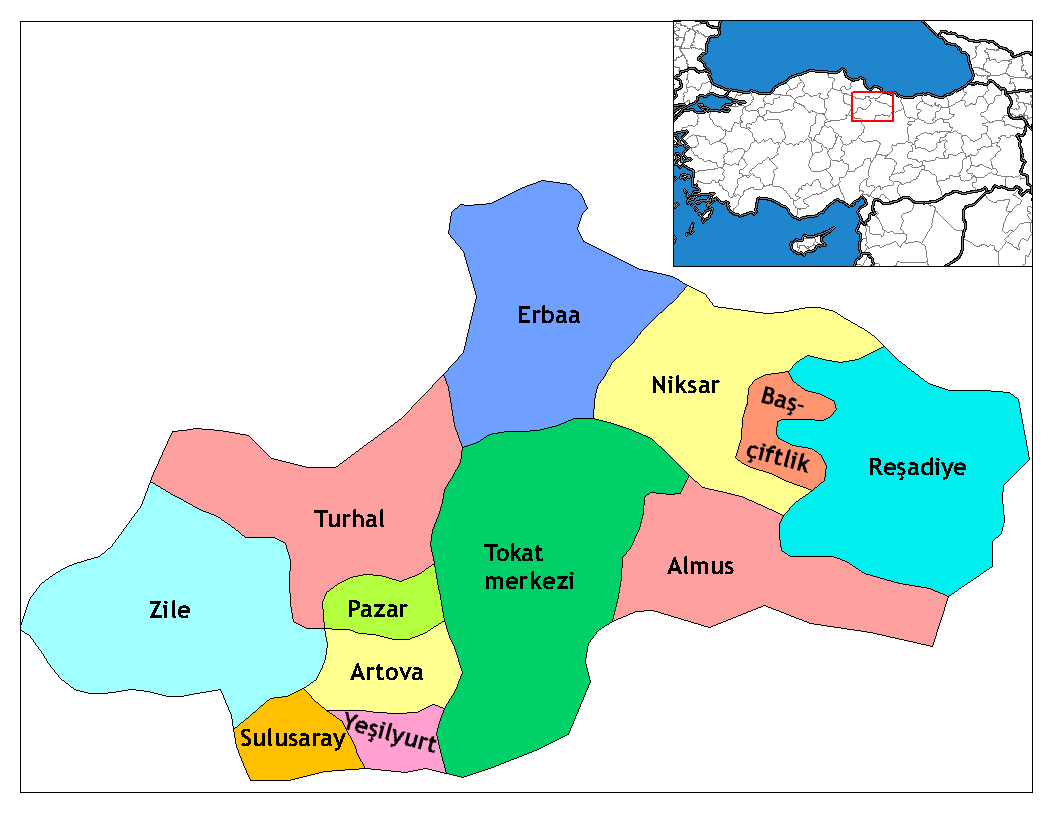
| Tigtulidong | Map of the districts of Tokat province in Turkey. Created by Rarelibra 17:52, 4 December 2006 (UTC) for public domain use, using MapInfo Professional v8.5 and various mapping resources. Edited by One Homo Sapiens Corrected text where İ,Ş,ı,ğ,or ş occurs in name. Source: [statoids-com]. Increased font size and enhanced color differences among adjacent districts. |
| Petsa | 4 Disyembre 2006 (original upload date) |
| Ginkuhaan | No machine-readable source provided. Own work assumed (based on copyright claims). |
| Awtor | No machine-readable author provided. Rarelibra assumed (based on copyright claims). |
Palilisensya:
| I, the copyright holder of this work, release this work into the public domain. This applies worldwide. In some countries this may not be legally possible; if so: I grant anyone the right to use this work for any purpose, without any conditions, unless such conditions are required by law. |
Kaagi han paypay
Pidlita an adlaw/oras para makit-an an fayl nga naggawas hito nga oras.
| Pitsa/Oras | Thumbnail | Mga dimensyon | Gumaramit | Komento | |
|---|---|---|---|---|---|
| waray pa kasasapawi | 02:33, 29 Disyembre 2008 | | 1,056 × 816 (34 nga KB) | One Homo Sapiens | Corrected text where İ,Ş,ı,ğ,or ş occurs in name. Source: [statoids-com]. Increased font size and enhanced color differences among adjacent districts. |
| 17:52, 4 Disyembre 2006 |  | 1,056 × 816 (33 nga KB) | Rarelibra | Map of the districts of Tokat province in Turkey. Created by ~~~~ for public domain use, using MapInfo Professional v8.5 and various mapping resources. |
Mga Sumpay
An mga nasunod nga mga pakli nasumpay hini nga paypay:
Global file usage
An masunod nga iba nga mga wiki in nagamit hini nga file:
- Paggamit ha ast.wikipedia.org
- Paggamit ha ca.wikipedia.org
- Paggamit ha de.wikipedia.org
- Paggamit ha diq.wikipedia.org
- Paggamit ha en.wikipedia.org
- Talk:Provinces of Turkey
- Tokat Province
- User talk:Rarelibra/Maps4
- Reşadiye shooting
- List of populated places in Tokat Province
- Districts of Turkey
- Governor of Tokat
- Başçiftlik District
- Tokat District
- Turhal District
- Reşadiye District
- Artova District
- Sulusaray District
- Yeşilyurt District, Tokat
- Zile District
- Almus District
- Erbaa District
- Niksar District
- Pazar District, Tokat
- Paggamit ha en.wiktionary.org
- Paggamit ha eo.wikipedia.org
- Paggamit ha es.wikipedia.org
- Paggamit ha eu.wikipedia.org
- Paggamit ha fa.wikipedia.org
- Paggamit ha fi.wikipedia.org
Kitaa durudamo nga global usage hinin nga file.