
Paypay:TokyoMapCurrent.png

Kadako hin nga pahiuna nga pagawas: 800 × 400 nga mga pixel. Iba nga mga resolusyon: 320 × 160 nga mga pixel | 640 × 320 nga mga pixel | 1,280 × 640 nga mga pixel.
Orihinal nga paypay (1,280 × 640 nga pixel, kadako han fayl: 54 nga KB, MIME nga tipo: image/png)

|
File:TokyoMap.svg is a vector version of this file. It should be used in place of this PNG file.
File:TokyoMapCurrent.png → File:TokyoMap.svg
For more information, see Help:SVG. |
 |
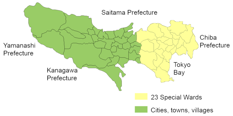
English: Map of mainland portion of Tokyo showing neighboring prefectures and Tokyo Bay
Deutsch: Karte der Präfektur Tokio, Gelb: die 23 Sonderbezirke; Grün: umliegende Gemeinden
Thanks to Aoki Shigenobu and [1]
Other versions:
- Italian: Image:TokyoMapCurrent it.png

|
Shigenobu AOKI, the copyright holder of this work, allows anyone to use it for any purpose including unrestricted redistribution, commercial use, and modification. |
Kaagi han paypay
Pidlita an adlaw/oras para makit-an an fayl nga naggawas hito nga oras.
| Pitsa/Oras | Thumbnail | Mga dimensyon | Gumaramit | Komento | |
|---|---|---|---|---|---|
| waray pa kasasapawi | 20:29, 23 Septyembre 2006 | | 1,280 × 640 (54 nga KB) | JR98664 | |
| 01:55, 24 Abril 2005 |  | 1,440 × 801 (43 nga KB) | Fg2 | Replaced color in key | |
| 11:52, 23 Abril 2005 |  | 1,440 × 801 (43 nga KB) | Fg2 |
Mga Sumpay
Waray pakli nga nagamit hinin nga file.
Global file usage
An masunod nga iba nga mga wiki in nagamit hini nga file:
- Paggamit ha en.wikipedia.org