
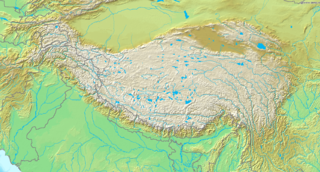
Paypay:Topografic map of Tibetan Plateau.png

Kadako hin nga pahiuna nga pagawas: 800 × 429 nga mga pixel. Iba nga mga resolusyon: 320 × 172 nga mga pixel | 640 × 343 nga mga pixel | 1,365 × 732 nga mga pixel.
Orihinal nga paypay (1,365 × 732 nga pixel, kadako han fayl: 663 nga KB, MIME nga tipo: image/png)
| Tigtulidong |
English: Topografic map of the Tibetan Plateau in Asia.
Français : Carte topographique du plateau tibetain.
|
||||
| Petsa | Waray kasabti an petsa | ||||
| Ginkuhaan | http://www.demis.nl/home/pages/Gallery/examples.htm | ||||
| Awtor | Unknown author | ||||
| Pagtugot (Gin-uutro paggamit inin nga file) |
|
Kaagi han paypay
Pidlita an adlaw/oras para makit-an an fayl nga naggawas hito nga oras.
| Pitsa/Oras | Thumbnail | Mga dimensyon | Gumaramit | Komento | |
|---|---|---|---|---|---|
| waray pa kasasapawi | 19:51, 26 Marso 2009 | | 1,365 × 732 (663 nga KB) | Botev | borders bold, lakes filled in blue |
| 19:02, 2 Septyembre 2005 |  | 1,365 × 732 (710 nga KB) | Mats Halldin~commonswiki | Map of Himalaya Bounding box West 66°, South 23°, East 108°, North 42°. {{demis-pd}} category:maps of Himalaya |
Mga Sumpay
An mga nasunod nga mga pakli nasumpay hini nga paypay:
Global file usage
An masunod nga iba nga mga wiki in nagamit hini nga file:
- Paggamit ha ar.wikipedia.org
- Paggamit ha ba.wikipedia.org
- Paggamit ha be-tarask.wikipedia.org
- Paggamit ha bn.wikipedia.org
- Paggamit ha ceb.wikipedia.org
- Paggamit ha ce.wikipedia.org
- Paggamit ha da.wikipedia.org
- Paggamit ha de.wikipedia.org
- Paggamit ha en.wikipedia.org
- Gyachung Kang
- 1950 Assam–Tibet earthquake
- Geladaindong Peak
- Karuo culture
- Haba Snow Mountain
- Anisodus tanguticus
- Outline of Tibet
- Alpine steppe
- Kang Yatze
- Module:Location map/data/Tibetan Plateau/doc
- User:BIO341prj
- 1927 Gulang earthquake
- 1932 Changma earthquake
- Pauhunri
- Guozha Lake
- User:HueSatLum/II
- Singhi Kangri
- Module:Location map/data/Tibetan Plateau
- Gasherbrum VI
- Phrynocephalus vlangalii
- Paggamit ha eu.wikipedia.org
- Paggamit ha fa.wikipedia.org
- Paggamit ha fo.wikipedia.org
- Paggamit ha fr.wikipedia.org
- Paggamit ha fr.wikibooks.org
- Paggamit ha gcr.wikipedia.org
- Paggamit ha hi.wikipedia.org
Kitaa durudamo nga global usage hinin nga file.