
Paypay:Topographic map of Liberia-en.svg

Size of this PNG preview of this SVG file: 799 × 600 nga mga pixel. Iba nga mga resolusyon: 320 × 240 nga mga pixel | 640 × 480 nga mga pixel | 1,023 × 768 nga mga pixel | 1,280 × 961 nga mga pixel | 2,560 × 1,922 nga mga pixel | 3,148 × 2,363 nga mga pixel.
Orihinal nga paypay (SVG nga fayl, ginbabanabanahan nga 3,148 × 2,363 nga mga pixel, kadako han fayl: 1.69 nga MB)
Dalikyat nga pulong
| Tigtulidong |
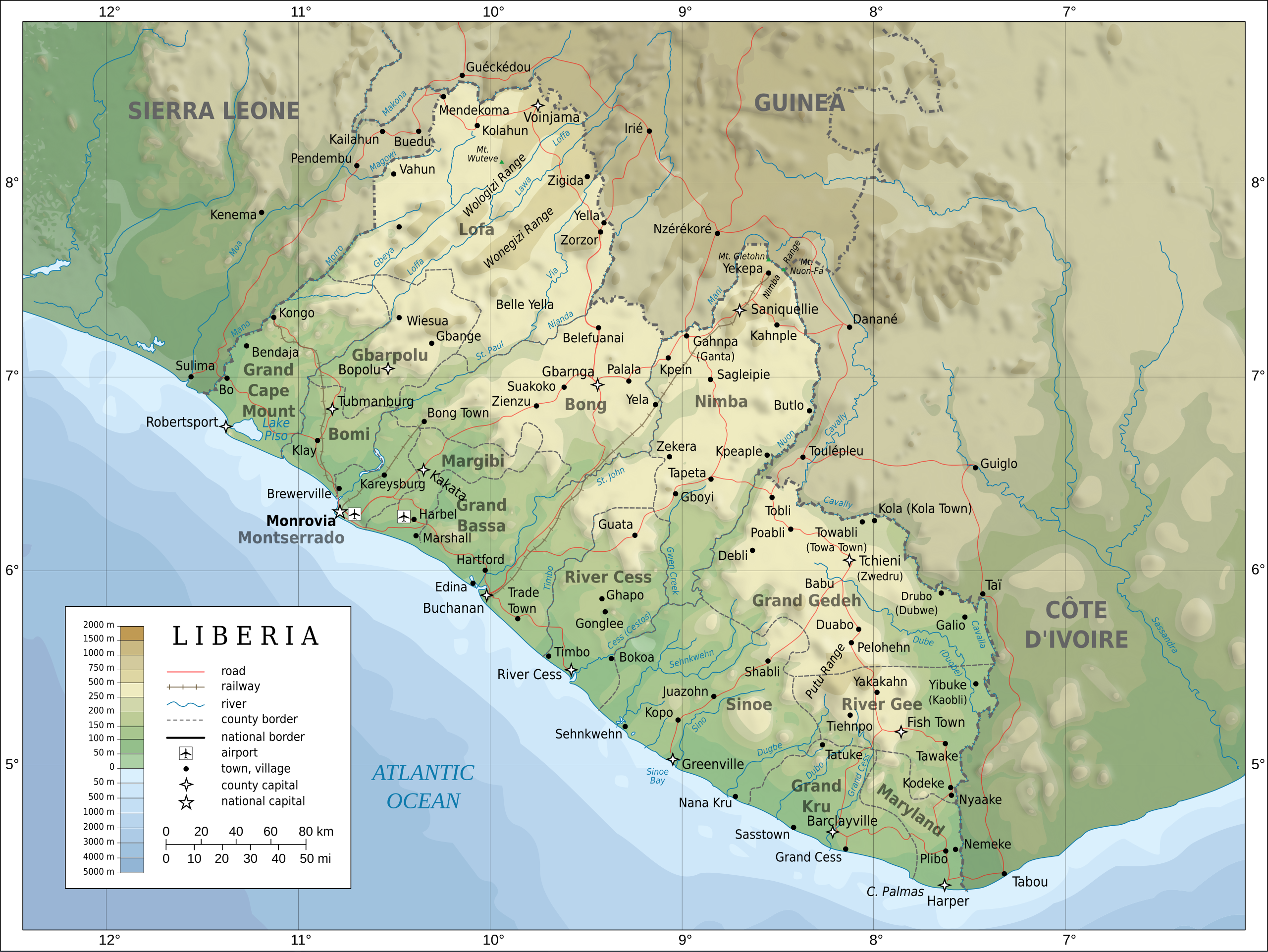
English: Topographic map of Liberia.
Français : Carte topographique du Liberia.
Suomi: Liberian topografinen kartta. |
| Petsa | |
| Ginkuhaan |
Self-made in Inkscape. Boundaries, rivers, roads, railroads, and place names based on a public domain United Nations map (Image:Un-liberia.png). Topography based on public domain GLOBE data from NOAA (http://www.ngdc.noaa.gov/mgg/topo/gltiles.html). Relief shading is an embedded PNG raster, derived from the GLOBE data using Perl. Bathymetry from NGDC ETOPO2. |
| Awtor | Oona Räisänen (Mysid) |
| Other versions |
Derivative works of this file: Railways in liberia-de.svg
|


|
This SVG file contains embedded text that can be translated into your language, using any capable SVG editor, text editor or the SVG Translate tool. For more information see: About translating SVG files. |
Palilisensya:
I, the copyright holder of this work, hereby publish it under the following licenses:

|
An permiso in ginhatag ha pagkopya, pagpakalat ngan/o pagliwat hinin nga dokumento ha ilarom han mga termino han GNU Free Documentation License, Version 1.2 o mas uruurhi nga version nga ginmantala han Free Software Foundation; nga may-ada waray Invariant Sections, waray Front-Cover Texts, ngan waray Back-Cover Texts. May-ada kopya hin lisensya nga ginlalakip ha seksyon nga may-ada pamagat nga GNU Free Documentation License. |
This file is licensed under the Creative Commons Attribution-Share Alike Attribution-Share Alike 4.0 International, 3.0 Unported, 2.5 Generic, 2.0 Generic and 1.0 Generic license.
- Talwas ka:
- para han pagpasaro – para han pagkopya, pagpakalat ngan pagpadangat han buhat
- para han pagremix – pag-adapt han buhat
- Ha ilarom an masunod nga mga kondisyon:
- attribution – Kinahanglanon mo tagan hin kaangayan nga credit, paghatag hin sumpay ngadto ha lisensya, ngan igbutang an imo ginbag-ohan nga binuhat. Puydi mo ini buhaton ha bisan ano nga resonable nga pamaagi, pero diri nimo pagawson nga an naghatag hin lisensya nag-eendorso ha imo o ha imo paggamit.
- share alike – Kun imo ginsagol-hin-otro, gin-iba, o gin-hingayad han buhat, ikaw in angay gud là magpakalat han imo gin-amot ha ilarom la han [http:creativecommons.org/share-your-work/licensing-considerations/compatible-licenses pareho o naangay nga lisensya] sugad han orihinal.
Puydi ka pumili hin lisenysa nga karuyag mo.
Kaagi han paypay
Pidlita an adlaw/oras para makit-an an fayl nga naggawas hito nga oras.
| Pitsa/Oras | Thumbnail | Mga dimensyon | Gumaramit | Komento | |
|---|---|---|---|---|---|
| waray pa kasasapawi | 20:08, 31 Hulyo 2010 | | 3,148 × 2,363 (1.69 nga MB) | Mysid | remove the false "dropoff" from land to sea in shading |
| 20:02, 31 Hulyo 2010 |  | 3,148 × 2,363 (1.69 nga MB) | Mysid | fixed a couple of symbols + clipped the shading layer | |
| 10:49, 19 Hulyo 2010 |  | 3,148 × 2,363 (2.64 nga MB) | Mysid | argh, forgot to update legend box | |
| 10:41, 19 Hulyo 2010 |  | 3,148 × 2,363 (2.64 nga MB) | Mysid | revised for consistency with my other maps | |
| 12:46, 25 Mayo 2008 |  | 3,148 × 2,363 (2.87 nga MB) | Mysid | border in image; layers in XML | |
| 18:34, 12 Mayo 2008 |  | 3,037 × 2,257 (2.82 nga MB) | Mysid | adding lakes, airports, legends | |
| 16:44, 12 Mayo 2008 |  | 3,037 × 2,257 (2.81 nga MB) | Mysid | == {{int:filedesc}} == {{Information |Description= {{en|Topographic map of Liberia.}} {{fr|Carte topographique du Liberia.}} {{fi|Liberian topografinen kartta.}} |Source=Self-made in Inkscape.<br/>Boundaries |
Mga Sumpay
Waray pakli nga nagamit hinin nga file.
Global file usage
An masunod nga iba nga mga wiki in nagamit hini nga file:
- Paggamit ha ar.wikipedia.org
- Paggamit ha az.wikipedia.org
- Paggamit ha ban.wikipedia.org
- Paggamit ha bcl.wikipedia.org
- Paggamit ha be-tarask.wikipedia.org
- Paggamit ha be.wikipedia.org
- Paggamit ha bn.wikipedia.org
- Paggamit ha ca.wikipedia.org
- Paggamit ha ckb.wikipedia.org
- Paggamit ha de.wikipedia.org
- Paggamit ha el.wikipedia.org
- Paggamit ha en.wikipedia.org
- Paggamit ha eu.wikipedia.org
- Paggamit ha fa.wikipedia.org
- Paggamit ha fi.wikipedia.org
- Paggamit ha fr.wikipedia.org
- Paggamit ha hr.wiktionary.org
- Paggamit ha hu.wikipedia.org
- Paggamit ha hy.wikipedia.org
- Paggamit ha id.wikipedia.org
- Paggamit ha io.wikipedia.org
- Paggamit ha is.wikipedia.org
- Paggamit ha it.wikipedia.org
- Paggamit ha ka.wikipedia.org
- Paggamit ha lt.wikipedia.org
- Paggamit ha mzn.wikipedia.org
- Paggamit ha nds.wikipedia.org
- Paggamit ha nl.wikipedia.org
- Paggamit ha pl.wikipedia.org
Kitaa durudamo nga global usage hinin nga file.