
Paypay:Toronto map.png

Kadako hin nga pahiuna nga pagawas: 800 × 595 nga mga pixel. Iba nga mga resolusyon: 320 × 238 nga mga pixel | 640 × 476 nga mga pixel | 1,024 × 761 nga mga pixel | 1,280 × 951 nga mga pixel | 1,500 × 1,115 nga mga pixel.
Orihinal nga paypay (1,500 × 1,115 nga pixel, kadako han fayl: 703 nga KB, MIME nga tipo: image/png)
|
| Tigtulidong |
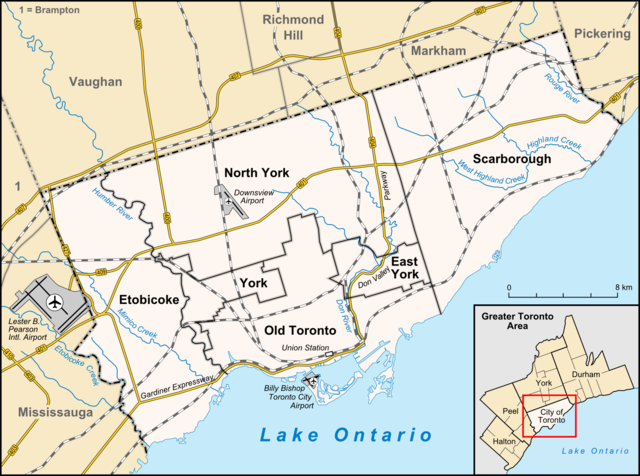
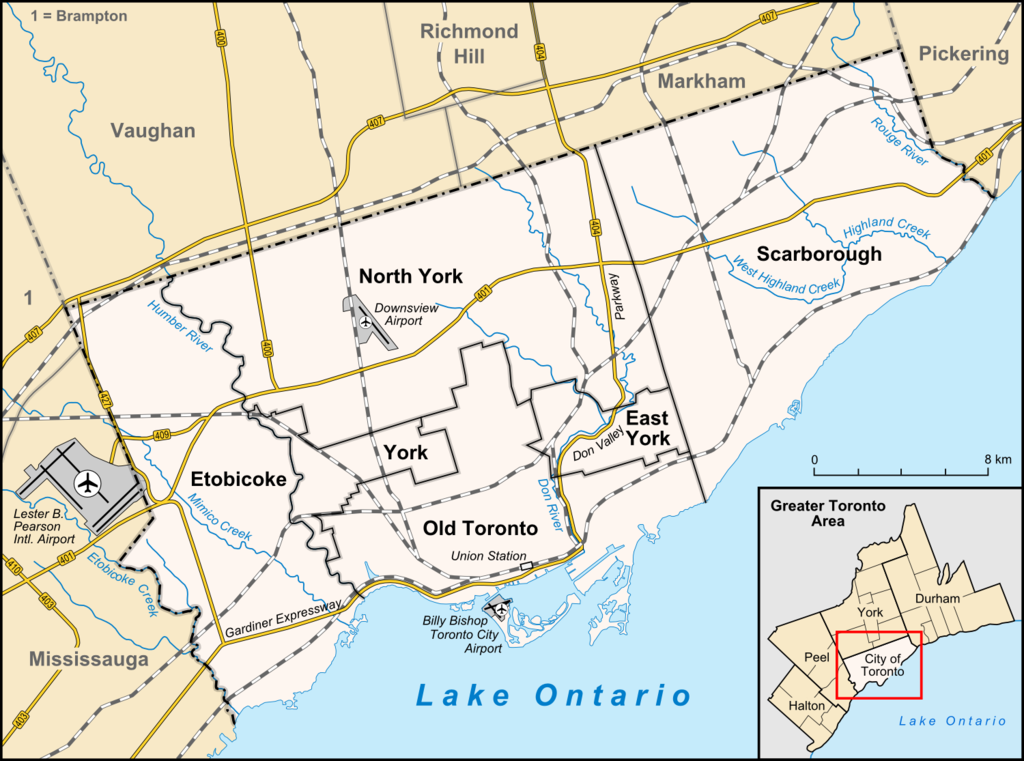
English: Map of Toronto
Français : Carte de Toronto
Deutsch: Karte von Toronto
Bahasa Indonesia: Peta kota Toronto |
| Petsa | |
| Ginkuhaan |
own work, used:
|
| Awtor | Lencer |

|
This map has been made or improved in the German Kartenwerkstatt (Map Lab). You can propose maps to improve as well.
|
Ini nga file in nakalisensya ha ilarom han Creative Commons Attribution-Share Alike 3.0 Unported license.
- Talwas ka:
- para han pagpasaro – para han pagkopya, pagpakalat ngan pagpadangat han buhat
- para han pagremix – pag-adapt han buhat
- Ha ilarom an masunod nga mga kondisyon:
- attribution – Kinahanglanon mo tagan hin kaangayan nga credit, paghatag hin sumpay ngadto ha lisensya, ngan igbutang an imo ginbag-ohan nga binuhat. Puydi mo ini buhaton ha bisan ano nga resonable nga pamaagi, pero diri nimo pagawson nga an naghatag hin lisensya nag-eendorso ha imo o ha imo paggamit.
- share alike – Kun imo ginsagol-hin-otro, gin-iba, o gin-hingayad han buhat, ikaw in angay gud là magpakalat han imo gin-amot ha ilarom la han [http:creativecommons.org/share-your-work/licensing-considerations/compatible-licenses pareho o naangay nga lisensya] sugad han orihinal.
Kaagi han paypay
Pidlita an adlaw/oras para makit-an an fayl nga naggawas hito nga oras.
| Pitsa/Oras | Thumbnail | Mga dimensyon | Gumaramit | Komento | |
|---|---|---|---|---|---|
| waray pa kasasapawi | 14:33, 3 Abril 2012 | | 1,500 × 1,115 (703 nga KB) | Lencer | + don river, minor adds of river names |
| 15:59, 29 Hunyo 2009 |  | 1,500 × 1,115 (585 nga KB) | SimonP | correct minor error | |
| 15:18, 29 Hunyo 2009 |  | 1,500 × 1,115 (585 nga KB) | SimonP | Corect East York border | |
| 10:56, 18 Hunyo 2009 |  | 1,500 × 1,115 (677 nga KB) | Lencer | + don valley parkway | |
| 18:56, 25 Marso 2009 |  | 1,500 × 1,115 (673 nga KB) | Lencer | Int. => Intl. | |
| 12:19, 18 Marso 2009 |  | 1,500 × 1,115 (672 nga KB) | Lencer | Vaugahn -> Vaughan | |
| 06:54, 10 Marso 2009 |  | 1,500 × 1,115 (673 nga KB) | Lencer | fix Greater Toronto Area | |
| 12:29, 9 Marso 2009 |  | 1,500 × 1,115 (672 nga KB) | Lencer | + Minimap, some fixes | |
| 19:10, 8 Marso 2009 |  | 1,500 × 1,116 (628 nga KB) | Lencer | weitere Kartenelemente erg., Farben geändert | |
| 20:02, 2 Marso 2009 |  | 1,500 × 1,116 (475 nga KB) | Lencer | Fehlerhafte Grenze bei York |
Mga Sumpay
An mga nasunod nga mga pakli nasumpay hini nga paypay:
Global file usage
An masunod nga iba nga mga wiki in nagamit hini nga file:
- Paggamit ha ar.wikipedia.org
- Paggamit ha ban.wikipedia.org
- Paggamit ha ceb.wikipedia.org
- Paggamit ha ckb.wikipedia.org
- Paggamit ha de.wikipedia.org
- Toronto
- Benutzer:Lencer
- Wikipedia:Exzellente Bilder/Karten und Satellitenbilder
- Liste der Ortsteile von Toronto
- Wikipedia:Kartenwerkstatt/Archiv/2009-03
- Wikipedia:Kandidaten für exzellente Bilder/Archiv2009/6
- Datei:Toronto map.png
- Toronto Fire Services
- Taber Hill
- Wikipedia:Kartenwerkstatt/Schaufenster
- Wikipedia:Exzellente Bilder/Kleine Bilder
- Paggamit ha en.wikipedia.org
- Toronto
- Rogers Centre
- Yonge–Dundas Square
- Billy Bishop Toronto City Airport
- Don River (Ontario)
- Forest Hill, Toronto
- Humber River (Ontario)
- The Annex
- Royal Ontario Museum
- Cabbagetown, Toronto
- Rosedale, Toronto
- The Beaches, Toronto
- High Park
- The Kingsway, Toronto
- Baby Point
- Bendale
- The Junction
- Little Italy, Toronto
- New Toronto
- Leslieville
- Kensington Market
- Scotiabank Arena
- Riverdale, Toronto
- Metropolitan Toronto
- Union Station (Toronto)
- Swansea, Toronto
- Parkdale, Toronto
- Rouge River (Ontario)
- Ontario Science Centre
- Black Creek Pioneer Village
- Agincourt, Toronto
Kitaa durudamo nga global usage hinin nga file.